
With the exception of a railway system, Jordan has a developed public and private transportation system. There are three international airports in Jordan. The Hedjaz Jordan Railway runs one passenger train a day each way.

U.S. Route 70 or U.S. Highway 70 is an east–west United States highway that runs for 2,381 miles (3,832 km) from eastern North Carolina to east-central Arizona. It is a major east–west highway of the Southeastern, Southern and Southwestern United States. Established as one of the original highways of 1926, it originally ran only to Holbrook, Arizona, then was extended in 1934 as a coast to coast route, with the current eastern terminus near the Atlantic Ocean in Atlantic, North Carolina, and the former western terminus near the Pacific Ocean in Los Angeles, California. The current western terminus was then truncated to US 60 / SR 77 in Globe, Arizona. Before the completion of the Interstate system, U.S. Highway 70 was sometimes referred to as the "Broadway of America", due to its status as one of the main east–west thoroughfares in the nation. It was also promoted as the "Treasure Trail" by the U.S. Highway 70 Association as of 1951.

U.S. Route 522 is a spur route of US 22 in the states of Virginia, West Virginia, Maryland, and Pennsylvania. The U.S. Highway travels in a north-south direction, and runs 308.59 miles (496.63 km) from US 60 near Powhatan, Virginia, to its northern terminus at US 11 and US 15 near Selinsgrove, Pennsylvania. US 522 serves many small cities and towns in the Piedmont, Blue Ridge Mountains, and northern Shenandoah Valley of Virginia. The highway serves the Virginia communities of Goochland, Mineral, Culpeper, the town of Washington, and Front Royal and the independent city of Winchester. US 522 then follows the Ridge-and-Valley Appalachians north and then east through the Eastern Panhandle of West Virginia, a 2-mile-wide (3.2 km) stretch of Western Maryland, and South Central Pennsylvania to its terminus in the Susquehanna Valley. The highway serves Berkeley Springs, West Virginia; Hancock, Maryland; and the Pennsylvania communities of McConnellsburg, Mount Union, Lewistown, and Middleburg.

Khatt is a mountainous village south-east of the city of Ras Al Khaimah, United Arab Emirates. Famous for its hot springs, and latterly home to a spa hotel, there is evidence that Khatt has been a site of constant human settlement since the stone age – a record of over 5,000 years of occupation.

Donald Everett Shebib was a Canadian film and television director. Shebib was a central figure in the development of English Canadian cinema who made several short documentaries for the National Film Board of Canada and CBC Television in the 1960s before turning to feature films, beginning with the influential Goin' Down the Road (1970) and what many call his masterpiece, Between Friends (1973). He soon became frustrated by the bureaucratic process of film funding in Canada and chronic problems with distribution as well as a string of box office disappointments. After Heartaches (1981), he made fewer films for theatrical release and worked more in television.

New York State Route 41 (NY 41) is a north–south state highway in Central New York in the United States. The southern terminus of the route is at an interchange with NY 17 in the town of Sanford in Broome County, New York. Its northern terminus is at an intersection with U.S. Route 20 (US 20) in the village of Skaneateles. The route is almost 100 miles (161 km) long and passes through Broome, Chenango, Cortland, and Onondaga counties. NY 41 was assigned as part of the 1930 renumbering of state highways in New York, replacing New York State Route 70 from Homer to Skaneateles. The route initially extended as far north as Jordan; however, NY 41 was cut back to its current northern terminus c. 1933.

Interstate 70 (I-70) is a part of the Interstate Highway System that runs from Cove Fort, Utah, to Woodlawn just outside of Baltimore, Maryland. In Maryland, the Interstate Highway runs 91.85 miles (147.82 km) from the Pennsylvania state line in Hancock east to the Interstate's eastern terminus at its junction with I-695. I-70 is the primary east–west Interstate in Maryland; the Interstate Highway connects Baltimore—and Washington, D.C., via I-270—with Western Maryland. The Interstate serves Frederick and Hagerstown directly and provides access to Cumberland via its junction with I-68 at Hancock. I-70 runs concurrently with its predecessor highway, U.S. Route 40 (US 40), from Hancock to Indian Springs in Washington County and from Frederick to West Friendship in Howard County.
Interstate 70 (I-70) is a part of the Interstate Highway System that travels from Cove Fort, Utah, to Baltimore, Maryland. In the US state of Illinois, the highway travels 160 miles (260 km) from the Missouri state line at the Mississippi River in Brooklyn east to the Indiana state line near Marshall. I-70, which travels in a generally east-northeast direction across the state parallel to and sometimes concurrent with U.S. Route 40 (US 40), connects St. Louis and the Metro East region of Illinois with the Indiana cities of Terre Haute and Indianapolis, as well as many small towns along the northern edge of Southern Illinois and the southern tier of the Central Illinois region. Within Metro East, I-70 has interchanges with I-64 in East St. Louis and I-55 near Troy. I-70 also has interchanges with the two Interstates that form St. Louis's beltway: I-255 near Collinsville and I-270 at the I-55 junction near Troy. East of the Metro East region, I-70 meets US 51 in Vandalia and both I-57 and US 45 in Effingham. Like all Interstate Highways, I-70 is a part of the National Highway System for its entire length in Illinois.

North Carolina Highway 751 (NC 751) is a north–south state road in North Carolina that runs from U.S. Route 64 (US 64) near Jordan Lake State Recreation Area, to US 70 Business near Durham. The road also continues south approximately 4.3 miles (6.9 km) to US 1 as New Hill-Olive Chapel Road (SR 1141). It runs largely parallel to NC 55, extending farther west towards Hillsborough which can be reached by continuing on US 70.
U.S. Route 70 (US 70) is a part of the United States Numbered Highway System that runs from Globe, Arizona, to the Crystal Coast of the US state of North Carolina. In North Carolina, it is a major 488-mile-long (785 km) east–west highway that runs from the Tennessee border to the Atlantic Ocean. From the Tennessee state line near Paint Rock to Asheville it follows the historic Dixie Highway, running concurrently with US 25. The highway connects several major cities including Asheville, High Point, Greensboro, Durham, Raleigh, Goldsboro, and New Bern. From Beaufort on east, US 70 shares part of the Outer Banks Scenic Byway, a National Scenic Byway, before ending in the community of Atlantic, located along Core Sound.

Wyoming Highway 211 is a 43.88-mile-long (70.62 km) Wyoming State Road known as Horse Creek Road within Laramie County, and as Iron Mountain Road in Platte County.
U.S. Route 70 is a transcontinental U.S. highway extending from Globe, Arizona to Atlantic, North Carolina. Along the way, 289.81 miles (466.40 km) of its route passes through the state of Oklahoma. Entering the state south of Davidson, the highway serves Oklahoma's southern tier before exiting the state east of Broken Bow. It serves the cities of Ardmore, Durant, Hugo, and Idabel, as well as Tillman, Cotton, Jefferson, Carter, Marshall, Bryan, Choctaw, and McCurtain counties.

Noah James Shebib, better known as 40, is a Canadian record producer, songwriter, record executive, and former child actor from Toronto, Ontario. He is best known for his production work for fellow Toronto native Drake, with extensive involvement on the entirety of Drake's discography since 2008. Shebib's production style, often described as downtempo and ambient, has become distinctive with Drake's sound. His other production credits include Lil Wayne, Alicia Keys, Beyoncé, Action Bronson, and Jamie Foxx.
Several special routes of U.S. Route 70 exist. In order from west to east, these special routes are as follows.
Harazpey-ye Gharbi Rural District is in the Central District of Mahmudabad County, Mazandaran province, Iran. Its capital is the village of Khatt-e Ahi.
"Mine" is a song recorded by American singer Beyoncé featuring Canadian rapper Drake. The song was written by Noah "40" Shebib, Drake, Beyoncé, Majid Jordan, Sidney "Omen" Brown and Key Wane, with production by Shebib, Jordan, Brown and Beyoncé for the latter's self-titled fifth studio album Beyoncé (2013). "Mine" is an alternative R&B song, that contains trap elements, African beats with muted modern hip hop as well as elements of afrobeats. Lyrically, Beyoncé reveals her everyday doubts regarding marriage and motherhood.

Majid Jordan is the debut studio album by Canadian R&B duo Majid Jordan, it was released on February 5, 2016, by OVO Sound and Warner Bros. Records. The album serves as a follow-up to their debut EP A Place Like This (2014). The album's sole guest appearance comes from Drake, who they have previously worked with on his single "Hold On, We're Going Home" in 2013.

Khatt Atui is a wadi in North Africa. This dry riverbed begins near Aousserd in the disputed territory of Western Sahara and runs southwest through the Dakhlet Nouadhibou and Inchiri Regions of Mauritania, ending at the Baie d'Aouati on the Atlantic coast east of Iouik, Mauritania in Banc d'Arguin National Park.

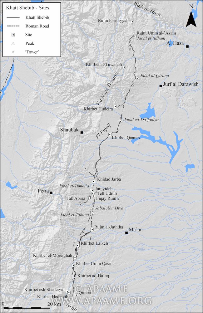
The Khatt Shebib is an ancient wall in Southern Jordan. The remains of the wall are 150 km long, making it the longest linear archaeological site in Jordan. The archaeological ruins were first identified by British diplomat Sir Alec Kirkbride in 1948. Ever since, a range of disciplines, including archaeologists, scientists and anthropologists, have studied the wall. The date of the Khatt Shebib's construction is still unknown, though it has been widely debated by archaeologists. This is evident as some archaeologists argue that the wall was built in the Iron Age, whilst others argue it was constructed in the Nabataean period.

