The Dwight D. Eisenhower National System of Interstate and Defense Highways, commonly known as the Interstate Highway System, or the Eisenhower Interstate System, is a network of controlled-access highways that forms part of the National Highway System in the United States. The system extends throughout the contiguous United States and has routes in Hawaii, Alaska, and Puerto Rico.

The United States Numbered Highway System is an integrated network of roads and highways numbered within a nationwide grid in the contiguous United States. As the designation and numbering of these highways were coordinated among the states, they are sometimes called Federal Highways, but the roadways were built and have always been maintained by state or local governments since their initial designation in 1926.
A highway is any public or private road or other public way on land. It includes not just major roads, but also other public roads and rights of way. In the United States, it is also used as an equivalent term to controlled-access highway, or a translation for motorway, Autobahn, autostrada, autoroute, etc.

The Trans-Canada Highway is a transcontinental federal–provincial highway system that travels through all ten provinces of Canada, from the Pacific Ocean on the west coast to the Atlantic Ocean on the east coast. The main route spans 7,476 km (4,645 mi) across the country, one of the longest routes of its type in the world. The highway system is recognizable by its distinctive white-on-green maple leaf route markers, although there are small variations in the markers in some provinces.

State Route 1 (SR 1) is a major north–south state highway that runs along most of the Pacific coastline of the U.S. state of California. At 656 miles (1,056 km), it is the longest state route in California, and the second-longest in the US after Montana Highway 200. SR 1 has several portions designated as either Pacific Coast Highway (PCH), Cabrillo Highway, Shoreline Highway, or Coast Highway. Its southern terminus is at Interstate 5 (I-5) near Dana Point in Orange County and its northern terminus is at U.S. Route 101 (US 101) near Leggett in Mendocino County. SR 1 also at times runs concurrently with US 101, most notably through a 54-mile (87 km) stretch in Ventura and Santa Barbara counties, and across the Golden Gate Bridge.

U.S. Route 66 or U.S. Highway 66 was one of the original highways in the United States Numbered Highway System. It was established on November 11, 1926, with road signs erected the following year. The highway, which became one of the most famous roads in the United States, ran from Chicago, Illinois, through Missouri, Kansas, Oklahoma, Texas, New Mexico, and Arizona before terminating in Santa Monica in Los Angeles County, California, covering a total of 2,448 miles (3,940 km).

The Lincoln Highway is one of the first transcontinental highways in the United States and one of the first highways designed expressly for automobiles. Conceived in 1912 by Indiana entrepreneur Carl G. Fisher, and formally dedicated October 31, 1913, the Lincoln Highway runs coast-to-coast from Times Square in New York City west to Lincoln Park in San Francisco. The full route originally ran through 13 states: New York, New Jersey, Pennsylvania, Ohio, Indiana, Illinois, Iowa, Nebraska, Colorado, Wyoming, Utah, Nevada, and California. In 1915, the "Colorado Loop" was removed, and in 1928, a realignment routed the Lincoln Highway through the northern tip of West Virginia. Thus, there are 14 states, 128 counties, and more than 700 cities, towns, and villages through which the highway passed at some time in its history.
King's Highway 401, commonly referred to as Highway 401 and also known by its official name as the Macdonald–Cartier Freeway or colloquially referred to as the four-oh-one, is a controlled-access 400-series highway in the Canadian province of Ontario. It stretches 828 kilometres (514 mi) from Windsor in the west to the Ontario–Quebec border in the east. The part of Highway 401 that passes through Toronto is North America's busiest highway, and one of the widest. Together with Quebec Autoroute 20, it forms the road transportation backbone of the Quebec City–Windsor Corridor, along which over half of Canada's population resides. It is also a Core Route in the National Highway System of Canada. The route is maintained by the Ministry of Transportation of Ontario (MTO) and patrolled by the Ontario Provincial Police. The speed limit is 100 km/h (62 mph) throughout the majority of its length, with the remaining exceptions being the posted 80 km/h (50 mph) limit westbound in Windsor, in most construction zones, and the 110 km/h (68 mph) speed limit on the 40 km (25 mi) stretch between Windsor and Tilbury that was raised on April 22, 2022, the 7 km (4.3 mi) extension east of the aforementioned, the 35 km (22 mi) stretch between Highway 35 / 115 and Cobourg, the 44 km (27 mi) stretch between Colborne and Belleville, the 66 km (41 mi) stretch between Belleville and Kingston, and the 107 km (66 mi) stretch between Highway 16 and the east end of the highway that were raised on July 12, 2024.

The Pan-American Highway is a network of roads stretching across the Americas, measuring about 30,000 kilometres (19,000 mi) in total length. Except for a break of about 100 km (60 mi) across the border between Colombia and Panama, the roads link most of the Pacific coastal countries of North America and South America in a connected highway system. According to Guinness World Records, the Pan-American Highway is the world's longest "motorable road".

Numbered highways in Canada are split by province, and a majority are maintained by their province or territory transportation department. With few exceptions, all highways in Canada are numbered. Nonetheless, every province has a number of highways that are better known locally by their name rather than their number. Some highways have additional letters added to their number: A is typically an alternate route, B is typically a business route, and other letters are used for bypass (truck) routes, connector routes, scenic routes, and spur routes. The territory of Nunavut has no highways.

The Grand Trunk Road is one of Asia's oldest and longest major roads. For at least 2,500 years it has linked Central Asia to the Indian subcontinent. It runs roughly 3,655 km (2,271 mi) from Teknaf, Bangladesh on the border with Myanmar west to Kabul, Afghanistan, passing through Chittagong and Dhaka in Bangladesh, Kolkata, Kanpur, Agra, Aligarh, Delhi, Amritsar in India, and Lahore, Rawalpindi, and Peshawar in Pakistan.

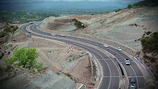
The national highways in India are a network of limited access roads owned by the Ministry of Road Transport and Highways. National highways have flyover access or some controlled-access, where entrance and exit is through the side of the flyover. At each highway intersection, flyovers are provided to bypass the traffic on the city, town, or village. These highways are designed for speeds of 100 km/h. Some national highways have interchanges in between, but do not have total controlled-access throughout the highways. The highways are constructed and managed by the Central Public Works Department (CPWD), the National Highways and Infrastructure Development Corporation Limited (NHIDCL), and the public works departments (PWD) of state governments. Currently, the longest national highway in India is National Highway 44 at 4,112 km. India started four laning of major national highways with the National Highway Development Project (NHDP). As of March 2022 India has approximately 35,000 km of four laned National highways.

A concurrency in a road network is an instance of one physical roadway bearing two or more different route numbers. When two roadways share the same right-of-way, it is sometimes called a common section or commons. Other terminology for a concurrency includes overlap, coincidence, duplex, triplex, multiplex, dual routing or triple routing.

The Federal Highway Administration (FHWA) is a division of the United States Department of Transportation that specializes in highway transportation. The agency's major activities are grouped into two programs, the Federal-aid Highway Program and the Federal Lands Highway Program. Its role had previously been performed by the Office of Road Inquiry, Office of Public Roads and the Bureau of Public Roads.

In the field of road transport, an interchange or a grade-separated junction is a road junction that uses grade separations to allow for the movement of traffic between two or more roadways or highways, using a system of interconnecting roadways to permit traffic on at least one of the routes to pass through the junction without interruption from crossing traffic streams. It differs from a standard intersection, where roads cross at grade. Interchanges are almost always used when at least one road is a controlled-access highway or a limited-access divided highway (expressway), though they are sometimes used at junctions between surface streets.

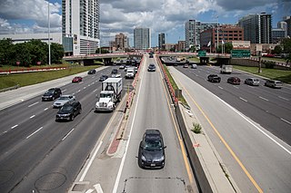
A controlled-access highway is a type of highway that has been designed for high-speed vehicular traffic, with all traffic flow—ingress and egress—regulated. Common English terms are freeway, motorway, and expressway. Other similar terms include throughway or thruway and parkway. Some of these may be limited-access highways, although this term can also refer to a class of highways with somewhat less isolation from other traffic.

Roads in India are an important mode of transport in India. India has a network of over 6,331,791 kilometres (3,934,393 mi) of roads. This is the second-largest road network in the world, after the United States. At of roads per square kilometre of land, the quantitative density of India's road network is equal to that of Hong Kong, and substantially higher than the United States, China, Brazil and Russia. Adjusted for its large population, India has approximately 5.13 kilometres (3.19 mi) of roads per 1,000 people, which is much lower than United States 20.5 kilometres (12.7 mi) but higher than that of China 3.6 kilometres (2.2 mi). India's road network carries over 71% of its freight and about 85% of passenger traffic.
National Highway 44 is a major north–south National Highway in India and is the longest in the country.