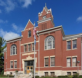
Antrim County is a county located in the U.S. state of Michigan. As of the 2020 Census, the population was 23,431. The county seat is Bellaire. The name is taken from County Antrim in Northern Ireland.

West Jordan is a city in Salt Lake County, Utah, United States. It is a suburb of Salt Lake City and has a mixed economy. According to the 2020 Census, the city had a population of 116,961, placing it as the third most populous in the state. The city occupies the southwest end of the Salt Lake Valley at an elevation of 4,330 feet (1,320 m). Named after the nearby Jordan River, the limits of the city begin on the river's western bank and end in the eastern foothills of the Oquirrh Mountains, where Kennecott Copper Mine, the world's largest man-made excavation, is located.
British Columbia Highway 14, named the West Coast (Sooke) Highway is the southernmost numbered route in the province of British Columbia. An east-west highway on the southwestern coast of Vancouver Island in the Capital Regional District, it is sometimes known as the Juan de Fuca Highway, as well as Sooke Road, Sooke being one of the largest communities that the highway passes through. Highway 14 first opened in 1953, extending west from Colwood, a suburb of Victoria, to the coastal community of Jordan River, and was extended all the way west to the remote community of Port Renfrew by 1975. The highway's eastern terminus was relocated to northern Langford in 2002.

State Route 156 is a primary state highway in the U.S. state of Virginia. The state highway runs 57.38 miles (92.34 km) from U.S. Route 301 and SR 35 in Templeton north to US 360 Business in Mechanicsville. SR 156 follows a circuitous route through the eastern part of the Richmond–Petersburg metropolitan area. South of the James River, the state highway connects Templeton in Prince George County with Hopewell, which is directly served by SR 156 Business. SR 156 crosses the James River on the Benjamin Harrison Memorial Bridge and briefly passes through Charles City County. For most of its length in Henrico and Hanover, the state highway is a rural road that provides access to several units of Richmond National Battlefield Park. However, SR 156 provides access to Richmond International Airport, Interstate 64 (I-64), and I-295 as it passes through the Richmond suburbs of Sandston and Highland Springs as a major highway.

Tafilah, also spelled Tafila, is a town with a population of 27,559 people in southern Jordan, located 183 kilometers (114 mi) southwest of Amman. It is the capital of Tafilah Governorate. It is well known for having green gardens which contain olive and fig trees, and grape-vines. Tafilah was first built by the Edomites and was called Tophel.

District of Shelburne, officially named the Municipality of the District of Shelburne, is a district municipality comprising the eastern section of Shelburne County, Nova Scotia, Canada, but does not include the Towns of Shelburne or Lockeport. Statistics Canada classifies the district municipality as a municipal district. It is home to the Bowers Meadows Wilderness Area.

New York State Route 31 (NY 31) is a state highway that extends for 208.74 miles (335.93 km) across western and central New York in the United States. The western terminus of the route is at an intersection with NY 104 in the city of Niagara Falls. Its eastern terminus is at a traffic circle with NY 26 in Vernon Center, a hamlet within the town of Vernon. Over its routing, NY 31 spans 10 counties and indirectly connects three major urban areas in Upstate New York: Buffalo–Niagara Falls, Rochester, and Syracuse. The route is one of the longest routes in New York State, paralleling two similarly lengthy routes, NY 104 to the north and NY 5 to the south, as well as the Erie Canal, as it proceeds east.
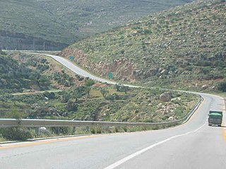
Allon Road is the name given by Israel to Routes 458, 508, and 578 in the West Bank, running roughly south–north along the eastern watershed of the Judaean and Samarian Hills, between Highway 1 near Kfar Adumim east of Jerusalem and Highway 90 at Mehola in the central Jordan Valley.

Tafilah is one of the governorates of Jordan, located about 180 km south-west of Amman, Jordan's capital.

Highway 5 or the Trans-Samaria Highway, is one of Israel's main highways, connecting the Mediterranean coast immediately north of Tel Aviv with the central Sharon plain and eastwards to Ariel and other Israeli settlements in the northern West Bank.

State Route 68 (SR-68) is a state highway in the U.S. state of Utah. It is a major thoroughfare throughout the Wasatch Front as it runs north–south for 70.8 miles (113.9 km), linking US-6 near Elberta to US-89 in Woods Cross. The route intersects several major freeways and highways in the Salt Lake City metropolitan area including I-215, I-80, and I-15. The route is more commonly referred to as Redwood Road, after the street it is routed along throughout Salt Lake County. The highway is also routed for a short distance along 500 South and 200 West in Bountiful and Camp Williams Road in Utah County. The route is a surface street for its entire length.
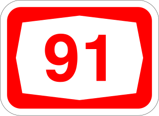
Highway 91 is an east-west highway in northern Israel and the Golan Heights. It extends through the Jordan Rift Valley and the central Golan Heights. It begins in the west at Mahanayim junction with Highway 90, and it ends in the east at Zivan junction near the Israeli settlement Ein Zivan, where it meets Highway 98. The road is 28 km long.
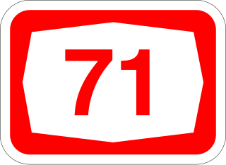
Highway 71 is an east-west highway that passes through the eastern Jezreel Valley and the Beit She'an Valley, below the north slopes of the Gilboa mountains, in northern Israel. The road follows a path parallel to the Harod Creek in the Harod Valley and to the Jezreel Valley railway. It is 35 kilometres (22 mi) long, and leads from Afula in the west, via Beit She'an, to the Jordan River Border Crossing in the east. The Navot interchange located approximately 10 km southeast of Afula provides a shortcut via Route 675 through the Ta'anakh region from Highway 71 and Beit She'an to Highway 65 and central Israel.

State Route 48 (SR-48) is a highway completely within Salt Lake County in northern Utah that connects Bangerter Highway with I-15 and US-89. The route is laid on portions of 7800 South, Redwood Road, and 7200 South. When the route was formed in 1927, it passed through the center of Midvale on Center Street. However, it was moved north onto 7200 South in 1965 to serve an exit of I-15.
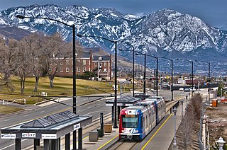
The Red Line is a light rail line on the TRAX system in the Salt Lake Valley of Utah operated by the Utah Transit Authority (UTA). It originally began operation in December 2001 as the peak-hour-only Sandy/University Line, running from the University of Utah south to Sandy Civic Center on the Blue Line. It was later rerouted to South Jordan and renamed the Red Line in August 2011, running as an all-day route. The current line runs from the University of Utah Medical Center in Salt Lake City through the south end of Downtown Salt Lake City, South Salt Lake, Murray, Midvale, West Jordan, and South Jordan to the University of Utah's South Jordan Medical Center in Daybreak.
Highway 57 is an east–west highway through central Israel and the West Bank. In the past, it was an uninterrupted road from Netanya, a city on the Mediterranean coast in the west, to Damia Bridge across the Jordan River in the east. The road existed in its full length from the time of the British Mandate, and parts of it are even older. Today the road is separated into three unconnected parts: the first from Netanya to Nitzanei Oz interchange at Highway 6, the second from there to an Israel Defense Forces checkpoint in Beka'ot in the northeastern West Bank, and the third from there until Damia Bridge. The middle portion of the road between Nitzanei Oz and Beka'ot passes through Tulkarm and Nablus, and most of it is located in Area A and Area B controlled by the Palestinian Authority. Various restrictions on traffic exist in these areas.

State Route 209 (SR-209) is a state highway in the U.S. state of Utah, following 9000 South and other east–west streets south of Salt Lake City. It connects the Bingham Canyon Mine with I-15 in Sandy and the ski areas of Little Cottonwood Canyon.

State Route 151 (SR-151), sometimes known as the South Jordan Parkway, is a state highway in the U.S. state of Utah connecting SR-154 in South Jordan to Interstate 15 (I-15) in Sandy. The route spans 4.24 miles (6.82 km) in southern Salt Lake County.
Highway 690 is a highway in the north-eastern region of the Canadian province of Saskatchewan that connects Highway 23 near Arborfield to Highway 789. The length of Highway 690 is 37.8 kilometres (23.5 mi).

Route 417 is an intercity road in Israel and the West Bank that stretches from the west side of Jerusalem to Ma'ale Adumim and Highway 1 east to the Jordan Valley.

