The Baltic Sea is an arm of the Atlantic Ocean that is enclosed by Denmark, Estonia, Finland, Germany, Latvia, Lithuania, Poland, Russia, Sweden, and the North and Central European Plain.

The Levant is the subregion that borders the Eastern Mediterranean sea to the west and core West Asia, or by the political term, Middle East, to the east. In its narrowest sense, which is in use today in archaeology and other cultural contexts, it is equivalent to Cyprus and a stretch of land bordering the Mediterranean Sea in western Asia: i.e. the historical region of Syria, which includes present-day Israel, Jordan, Lebanon, Syria, the Palestinian territories and most of Turkey southwest of the middle Euphrates. Its overwhelming characteristic is that it represents the land bridge between Africa and Eurasia. In its widest historical sense, the Levant included all of the Eastern Mediterranean with its islands; that is, it included all of the countries along the Eastern Mediterranean shores, extending from Greece in Southern Europe to Egypt and Cyrenaica in Northern Africa.

North Rhine-Westphalia or North-Rhine/Westphalia, commonly shortened to NRW, is a state (Bundesland) in Western Germany. With more than 18 million inhabitants, it is the most populous state in Germany. Apart from the city-states, it is also the most densely populated state in Germany. Covering an area of 34,084 km2 (13,160 sq mi), it is the fourth-largest German state by size.

The Elbe is one of the major rivers of Central Europe. It rises in the Giant Mountains of the northern Czech Republic before traversing much of Bohemia, then Germany and flowing into the North Sea at Cuxhaven, 110 kilometres northwest of Hamburg. Its total length is 1,094 km (680 mi).

East Sussex is a ceremonial county in South East England. It is bordered by Kent to the northeast, West Sussex to the west, Surrey to the northwest, and the English Channel to the south. The largest settlement is the city of Brighton and Hove, and the county town is Lewes.

Sylt is an island in northern Germany, part of Nordfriesland district, Schleswig-Holstein, with a distinctively shaped shoreline. It belongs to the North Frisian Islands and is the largest island in North Frisia. The northernmost island of Germany, it is known for its tourist resorts, notably Westerland, Kampen and Wenningstedt-Braderup, as well as for its 40-kilometre-long (25-mile) sandy beach. It is frequently covered by the media in connection with its exposed situation in the North Sea and its ongoing loss of land during storm tides. Since 1927, Sylt has been connected to the mainland by the Hindenburgdamm causeway. In later years, it has been a resort for the German jet set and tourists in search of occasional celebrity sightings.

Vlieland is a municipality and island in the northern Netherlands. The municipality of Vlieland is the second most sparsely populated municipality in the Netherlands, after Schiermonnikoog.

Cleethorpes is a seaside town on the estuary of the Humber in North East Lincolnshire, Lincolnshire, England with a population of 29,678 in 2021. It has been permanently occupied since the 6th century, with fishing as its original industry, then developing into a resort in the 19th century. Before becoming a unified town, Cleethorpes was made up of the three small villages of Itterby, Oole and Thrunscoe.

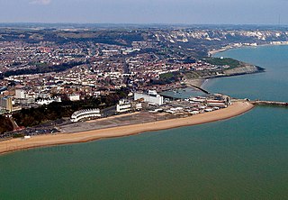
Folkestone and Hythe is a local government district in Kent, England. It lies in the south-east of the county, on the coast of the English Channel. The district was formed in 1974 and was originally named Shepway after one of the ancient lathes of Kent, which had covered a similar area. The district was renamed in 2018. The council is based in Folkestone, the district's largest town. The district also includes the towns of Hawkinge, Hythe, Lydd and New Romney, along with numerous villages and surrounding rural areas.

Lake Walen, also known as Lake Walenstadt or Walensee, is one of the larger lakes in Switzerland. Located in the east of the country, about two thirds of its area are in the canton of St. Gallen and about one third in the canton of Glarus.

Rota, also known as the "Friendly Island", is the southernmost island of the United States Commonwealth of the Northern Mariana Islands (CNMI) and the third southernmost of the Marianas Archipelago. In early Spanish records it is called "Zarpana"; the name Rota may have come from the Spaniards possibly naming the island after the municipality of Rota, Spain. It lies approximately 40 nautical miles (74 km) north-northeast of the United States territory of Guam. Sinapalo village is the largest and most populated, followed by Songsong village (Songsong). Rota also functions as one of the four municipalities of the CNMI.

England comprises most of the central and southern two-thirds of the island of Great Britain, in addition to a number of small islands of which the largest is the Isle of Wight. England is bordered to the north by Scotland and to the west by Wales. It is closer to continental Europe than any other part of mainland Britain, divided from France only by a 33 km (21 mi) sea gap, the English Channel. The 50 km (31 mi) Channel Tunnel, near Folkestone, directly links England to mainland Europe. The English/French border is halfway along the tunnel.

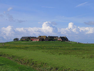
A terp, also known as a wierde, woerd, warf, warft, werf, werve, wurt or værft, is an artificial dwelling mound found on the North European Plain that has been created to provide safe ground during storm surges, high tides and sea or river flooding. The various terms used reflect the regional dialects of the North European region.

The Black Sea Germans are ethnic Germans who left their homelands, and settled in territories off the north coast of the Black Sea, mostly in the territories of the southern Russian Empire.

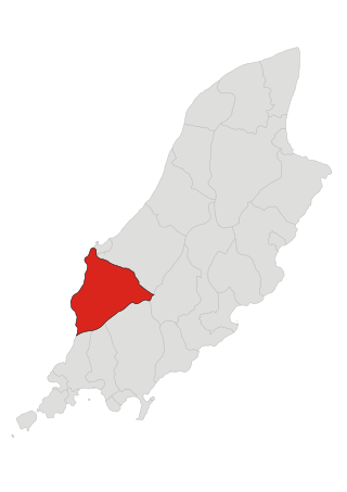
Patrick is one of the seventeen historic parishes of the Isle of Man.

Helvíkovice is a municipality and village in Ústí nad Orlicí District in the Pardubice Region of the Czech Republic. It has about 500 inhabitants.

Ashington is a town and civil parish in Northumberland, England, with a population of 27,864 at the 2011 Census. It was once a centre of the coal mining industry. The town is 15 miles (24 km) north of Newcastle upon Tyne, west of the A189 and bordered to the south by the River Wansbeck. Many inhabitants have a distinctive accent and dialect known as Pitmatic. This varies from the regional dialect known as Geordie.

Hagermarsch is a village and municipality in the district of Aurich, in Lower Saxony, Germany. It is located northeast of the city of Norden. Together with four other municipalities in the region, it is part of the municipal association (Samtgemeinde) of Hage, of which Hagermarsch is the smallest population-wise.

Hilgenried Bay is a bay on the German North Sea coast near Hilgenriedersiel, a village in the municipality of Hagermarsch in the Lower Saxon county of Aurich. It was probably formed during the Dunkirk transgression as a result of the washing out of the mouth of one or more small streams, but has now largely silted up.
Theener is a village in the region of East Frisia, Lower Saxony, Germany. It is an Ortsteil of the municipality of Hagermarsch, part of the municipal association (Samtgemeinde) of Hage. It is a dispersed settlement to the south of Hilgenriedersiel. Historically, the village was first recorded in 1787 as Thener and has been officially registered under its current name since 1818.


