Crinkle Crags is a fell in the English Lake District in the county of Cumbria. It forms part of two major rings of mountains, surrounding the valleys of Great Langdale and Upper Eskdale. The name reflects the fell's physical appearance as its summit ridge is a series of five rises and depressions (crinkles) that are very distinctive from the valley floor. In Old English, cringol means twisted or wrinkled.

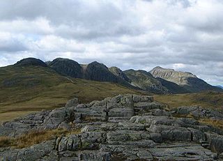
The Merrick, or simply Merrick, is a mountain in the Range of the Awful Hand, a sub-range of the Galloway Hills range, part of the Southern Uplands of Scotland. The summit elevation is 843 metres, making it the highest mountain in the Southern Uplands and southern Scotland.

Dalmuir is an area nine miles northwest of Glasgow, Scotland, on the western side of Clydebank, and part of West Dunbartonshire Council Area. The name is a lowland Scots derivation of the Gaelic meaning Big Field. The area was originally two separate villages with Dalmuir Shore joining with Clydebank in 1886 and Dalmuir Village in 1906, during a period of rapid industrialization and expansion. Dalmuir is bounded by the village of Old Kilpatrick to the west, the Mountblow and Parkhall housing schemes to the north, and the Clydebank town centre area to the east. To the south is the River Clyde.

The United Kingdom is one of the best locations for wind power in the world and is considered to be the best in Europe. By the beginning of March 2022, the UK had 11,091 wind turbines with a total installed capacity of over 24.6 gigawatts (GW): 14.1 GW of onshore capacity and 10.4 GW of offshore capacity, the sixth largest capacity of any country in 2019. Wind power contributed 24.8% of UK electricity supplied in 2020, having surpassed coal in 2016 and nuclear in 2018. It is the largest source of renewable electricity in the UK. The UK Government has committed to a major expansion of offshore capacity by 2030.

Muncaster Fell is a fell at the far western edge of the Lake District National Park, in Cumbria, England. Muncaster Fell is a long, narrow ridge of land, approximately 1.2 km wide and 6 km long, lying between the River Mite to the north, and River Esk to the south. The fell rises from the coast near Ravenglass village to its highest point at Hooker Crag (231 m). The ridge then continues to the north-east, dropping gently to its furthest prominence at Silver Knott (174 m). The fell then falls away rapidly to the village of Eskdale Green at its north-eastern tip.

Wind power in Scotland is the fastest-growing renewable energy technology, with 9,347 MW of installed wind power capacity as of June 2020. This included 8,366 MW from onshore wind in Scotland and 981 MW of offshore wind generators.

Croghan Mountain or Croghan Kinsella at 606 metres (1,988 ft), is the 211th–highest peak in Ireland on the Arderin scale, and the 258th–highest peak on the Vandeleur-Lynam scale. Croghan is situated at the far southeastern end of the Wicklow Mountains on the Wicklow and Wexford border, in Ireland.
Ben Cleuch is a hill in the Ochil Hills range, part of the Central Lowlands of Scotland. It is the highest point in the range, Clackmannanshire and the Central Belt of Scotland; the summit is marked by a trig point within a stone windshelter and a viewpoint indicator.
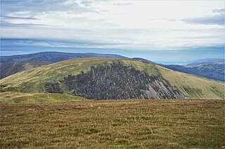
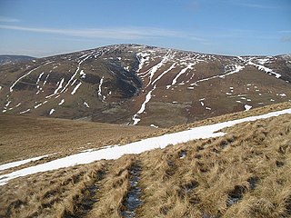
Lochcraig Head is a hill in the Moffat Hills range, part of the Southern Uplands of Scotland. The second highest in the range, its southern slopes drop dramatically into Loch Skeen, the highest loch in the Southern Uplands, from which the Grey Mare's Tail waterfall originates. A common ascent is as a round from the car park to the south, taking in White Coomb.
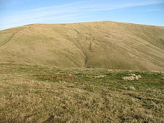
Cramalt Craig is a hill in the Manor Hills range, part of the Southern Uplands of Scotland. The second highest in the range and third highest in southern Scotland, it was previously also a Corbett until a 2013 survey by Alan Dawson found the col between it and Broad Law to be a few metres short of 500 ft. It is climbed almost solely from its southern sides at the Megget Stane or Cramalt Farm, taking in the neighbouring hills.

Wind Fell is a hill in the Ettrick Hills range, part of the Southern Uplands of Scotland. The Dumfries and Galloway-Scottish Borders border lies across the hill. Close to the Southern Upland Way, routes of ascent frequently incorporate its track and it is almost always climbed along with the neighbouring hills.

Whitehope Heights is a hill in the Moffat Hills range, part of the Southern Uplands of Scotland. The lowest Donald hill in the range, it is separated from Hart Fell by a steep grassy cleuch known as The Gyle. Like its neighbour, the Dumfries and Galloway-Scottish Borders border runs along its summit. The southern slopes of the hill are part of the Corehead hill farm, an area owned by the Borders Forest Trust for the purposes of habitat regeneration; as a result, a large deer fence lines the boundary. East of the Devil's Beef Tub and Annandale Way, it is most frequently climbed from this direction, but ascents from Hart Fell are also common.

Bowbeat Hill is a hill in the Moorfoot Hills range, part of the Southern Uplands of Scotland. It lends its name to Bowbeat Onshore Wind Farm built on the hill and commissioned in 2003. The wind farm produces 31.2MW of power using 24 turbines. It is commonly ascended with its neighbouring hills from Gladhouse Reservoir to the north.

Hudderstone is a hill in the Culter Hills range, part of the Southern Uplands of Scotland. Normally ascended as part of a popular round, its southern flanks are dotted with turbines from the Clyde Extension Wind Farm.
Whitehope Law is a hill in the Moorfoot Hills range, part of the Southern Uplands of Scotland. A relatively isolated hill, it is frequently climbed on its own from the B709 road to its south and east. A farm to the south lends its name to the hill.

The Rhinns of Kells are a range of hills in the Galloway Hills range, part of the Southern Uplands of Scotland. The most easterly of three parallel ridges, they are neighboured to the west by the Range of the Awful Hand and the Dungeon Hills. The eastern portion of the Minnigaff Hills range lies immediately southwest of the range. In total, these four ranges are part of the Galloway Forest Park. The ridge is located entirely within Dumfries and Galloway, with the base of the western flanks being a northwestern boundary of the county.
The Minnigaff Hills are a range of hills in the Galloway Hills range, part of the Southern Uplands of Scotland. A southerly range, they are perpendicular to the Range of the Awful Hand, Dungeon Hills and Rhinns of Kells to the north. In total, these four ranges are part of the Galloway Forest Park.

The Culter Hills, Coulter Fells or variations thereof, are a range of hills, part of the Southern Uplands of Scotland. They are neighboured to the east by the Manor Hills and are split roughly in half by the border between South Lanarkshire and the Scottish Borders.

The Ettrick Hills are a range of hills, part of the Southern Uplands of Scotland. They are neighboured to the northwest by the Moffat Hills and are located mainly within the Scottish Borders, however the Dumfries and Galloway border covers the south and southwesterly flanks.
