Related Research Articles
Logan County Airport is a public use airport located 2.2 nautical miles northeast of the central business district of Lincoln, a city in Logan County, Illinois, United States. It is owned by the Logan County Board. The airport is also the site of the National Weather Service Central Illinois.
Shelby County Airport is a public airport located three miles (4.8 km) west of the central business district (CBD) of Shelbyville, a city in Shelby County, Illinois, United States. A significant amount of the airport's traffic is from agricultural aviation serving nearby areas.
Zephyrhills Municipal Airport is a public use airport in Pasco County, Florida, United States. It is owned by the City of Zephyrhills and located one nautical mile (2 km) southeast of its central business district. This airport is included in the National Plan of Integrated Airport Systems for 2011–2015, which categorized it as a general aviation facility.

Toledo Suburban Airport is a public use airport located two nautical miles southwest of the central business district of Lambertville, a city in Monroe County, Michigan, United States. It is located just north of Michigan's border with Ohio and northwest of the city of Toledo, Ohio. It is included in the Federal Aviation Administration (FAA) National Plan of Integrated Airport Systems for 2017–2021, in which it is categorized as a general aviation facility.
Rantoul National Aviation Center, also known as Frank Elliott Field, is a public use airport located in Rantoul, a village in Champaign County, Illinois, United States. It is owned by the Village of Rantoul.
Fremont Municipal Airport is a city-owned public-use airport located three nautical miles (6 km) southwest of the central business district of Fremont, a city in Newaygo County, Michigan, United States. The airport is uncontrolled, and is used for general aviation purposes. Skydiving and ultralight activity are also conducted at the field. It is included in the Federal Aviation Administration (FAA) National Plan of Integrated Airport Systems for 2017–2021, in which it is categorized as a local general aviation facility.

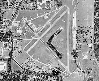
Joliet Regional Airport is a public use airport located four nautical miles (7 km) west of the central business district of Joliet, a city in Will County, Illinois, United States. It is owned by the Joliet Park District.
For the airport near Cave Junction, Oregon, see Illinois Valley Airport
Covington Municipal Airport is a city-owned public-use airport located three nautical miles north of the central business district of Covington, a city in Newton County, Georgia, United States.

Pekin Municipal Airport is a city-owned public-use airport located four nautical miles south of the central business district of Pekin, a city in Tazewell County, Illinois, United States. It is included in the FAA's National Plan of Integrated Airport Systems for 2011–2015, which categorized it as a general aviation facility.
Crawford County Airport is a public use airport located four nautical miles east of the central business district of Robinson, a city in Crawford County, Illinois, United States. It is owned by the Crawford County Airport Authority and was formerly known as Robinson Municipal Airport. This airport is included in the National Plan of Integrated Airport Systems for 2011–2015, which categorized it as a general aviation facility.
Hastings Airport is a public use airport located three nautical miles (6 km) west of the central business district of Hastings, a city in Barry County, Michigan, United States. It is owned by the city and county and is also known as Hastings City/Barry County Airport.
Salem–Leckrone Airport is a public use airport located two nautical miles (4 km) northwest of the central business district of Salem, a city in Marion County, Illinois, United States. It is owned by the Salem Airport Authority. This airport is included in the National Plan of Integrated Airport Systems for 2011–2015, which categorized it as a general aviation facility.
The Whiteside County Airport, also known as Joseph H. Bittorf Field, is a public-use airport serving Rock Falls, Illinois, United States, as well as the Sauk Valley and Dixon area.
The Dacy Airport is a privately owned, public-use airport located 1 mile southwest Harvard, Illinois.
Pontiac Municipal Airport is a public use airport 3 miles north of Pontiac in Livingston County, Illinois. The airport is publicly owned by the City of Pontiac.
Sparta Community Airport, also known as Hunter Field, is a civil, public use airport 2 miles north of Sparta in Randolph County, Illinois. The airport is publicly owned by the Sparta Community Airport Authority.
Dwight Airport is a public-use airport located three miles north of Dwight, Illinois. The airport is privately owned by the Dwight Aero Service.
Boyne City Municipal Airport is a public use airport located in the city limits of Boyne City, Michigan. The airport is publicly owned by the City of Boyne City. It is four nautical miles southeast of the Boyne Mountain Airport.
Skydive Chicago Airport is a privately owned, public use airport located four miles northeast of Ottawa, Illinois. The airport is the centerpiece of the Skydive Chicago Resort. Camping, RV parking, and lodging are available, as is a bar, lounge, observation area, and café.
References
- 1 2 3 4 FAA Airport Form 5010 for 0C2 PDF , effective 2008-09-25.
- 1 2 "K0C2". fltplan.com. Retrieved 2022-07-23.
- 1 2 "Hinckley Airport – K0C2". AirportGuide. Retrieved 2022-07-23.
- 1 2 "0C2 – Hinckley Airport". SkyVector. Retrieved 2022-07-23.
- 1 2 3 "Hinckley Airport – 0C2 – AOPA". Aircraft Owners and Pilots (AOPA). Retrieved 2022-07-23.
- ↑ "SKYDIVING PLANE CRASHES IN ILLINOIS, KILLING 12". Washington Post. Retrieved 2022-07-23.