
Dhule is a city located in the Dhule District in the northwestern part of Maharashtra state, India known as West Khandesh. Situated on the banks of Panzara River, Dhule is the regional headquarters of MIDC, RTO, and MTDC.

Thane district is a district in the Konkan Division of Maharashtra, India. At the 2011 Census it was the most populated district in the country, with 11,060,148 inhabitants; however, in August 2014 the district was split into two with the creation of a new Palghar district, leaving the reduced Thane district with a 2011 census population of 8,070,032. The headquarters of the district is the city of Thane. Other major cities in the district are Navi Mumbai, Kalyan-Dombivli, Mira-Bhayander, Bhiwandi, Ulhasnagar, Ambarnath, Badlapur, Murbad and Shahapur.
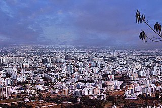
Nashik ) is a city in the northern region of the Indian state of Maharashtra. Situated on the banks of the river Godavari. The population of Nashik city is around 2.2 million and is emerging as one of the fastest-growing cities in India. Nashik is located about 165 km (103 mi) northeast of the state capital Mumbai, and about 210 km (130 mi) north of Pune. The Mumbai-Pune-Nashik region is called the "Golden Triangle of Maharashtra". With its high agricultural production, Nashik is dubbed the Napa Valley of India and the "Wine Capital of India" as more than half of India's vineyards and wineries are located here. Around 90% of all Indian wine comes from the Nashik Valley. Nashik is one of the Hindu pilgrimage sites of the Kumbh Mela, which is held every 12 years.

Buldhana district is located in the Amravati division of Maharashtra, India. It is situated at the western border of Vidarbha region and is 500 km away from the state capital, Mumbai. The district has towns and cities like deulghat, dhad, mehakar, Shegaon, Malkapur, Khamgaon, Lonar and Chikhli. It is surrounded by Madhya Pradesh in the north, Akola, Washim, and Amravati districts on the east, Jalna district on the south, and Jalgaon and Aurangabad districts on the west. Khamgaon is the largest city in the district.

Bhandara District is an administrative district in the state of Maharashtra in India. The name Bhandara is a corruption of Bhanara. Reference to Bhanara is found in an inscription of 1100 A.D. traced at Ratanpur. The district headquarters are located at Bhandara. The district occupies an area of 3717 km2 and has a population of 1,200,334, of which 19.48% are urban as of 2011. The growth rate of Bhandara is 5.56% Bhandara has a mixed economy with agriculture, industries and forest resources. Bhandara is known for its large production of rice. Tumsar, a tahsil town, is a noted rice market. Bhandara town is also known as "Brass City" owing to the presence of a large brass products industry. Bhandara has several tourist destinations, like Ambagad Fort, Brahmi, Chinchgad, and Dighori.

Osmanabad District, officially known as Dharashiv District, is an administrative district in the Marathwada region in the Indian state of Maharashtra. The district headquarter is located at Osmanabad. The District of Osmanabad derives its name from the last ruler of Hyderabad, the 7th Nizam, Mir Osman Ali Khan, of which the region was a part till 1947. This region was earlier part of The Hyderabad State until Independence.This primarily rural district occupies an area of 7,569 km2 (2,922 sq mi) of which 241.4 km2 (93.2 sq mi) is urban and has a population of 1,657,576 of which 16.96% were urban.
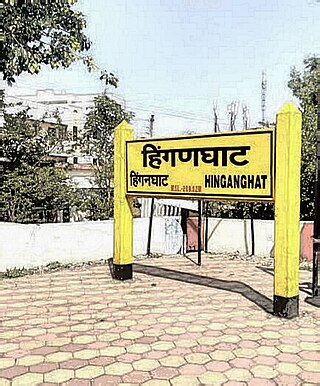
Hinganghat is a city in Wardha district of the Indian state of Maharashtra. The city is administered by a Municipal Council and is located about 35 km (22 mi) from Wardha and 72 km (45 mi) from Maharashtra's second capital Nagpur.

Nagpur district is a district in the Vidarbha region of Maharashtra state in central India. The city of Nagpur is the district administrative centre. The district is part of Nagpur Division.
Bhandara is a city located in the Bhandara district of Maharashtra State of India, near the bank of confluence of river Wainganga and its tributary Sur. It serves the administrative headquarters of eponymous Bhandara Taluka and Bhandara district. It is connected with NH-53 and NH-247.
Pusad is a city in the Yavatmal district located in Vidarbha region of Maharashtra state of India. It is named after the Pus river. Its ancient name was 'Pushpawanti'. Pusad is second largest city of Yavatmal district. For last 20 years Pusad is being tried to be promoted to the stature of district but due to lack of administration of governing bodies it is only a dream of the people.
Gadhinglaj ([ɡəɖᵊɦiŋɡləd͡z]) is a city in India in the Kolhapur district in the southwest corner of the state of Maharashtra, India. It is located on the banks of the river Hiranyakeshi. It is the Taluka (Tehsil) headquarters of Gadhinglaj Taluka and a subdivision headquarters of the Gadhinglaj Subdivision of the Kolhapur District. It is governed by a municipal council. The rapidly growing city is the third largest in the Kolhapur District, with population of more than 50,000. Places to visit include Samagad fort, temples and beautiful weather.

Kalameshwar-Bramhani is a city and a municipal council also a major Industrial hub in Nagpur district in the Indian state of Maharashtra. It is connected to National Highways NH-353I, NH-353J & NH-547E.

Mohpa is a city with a municipal council in Nagpur district in the Indian state of Maharashtra. Although physically located within Kalmeshwar taluka, it is not subject to taluka governance. It is divided in to basically three part

Sausar (Saunsar) is a Municipal Council in the central India in the state of Madhya Pradesh. Sausar lies in Vidharbha region, Nagpur is the center for all the economic activities in this region which is just 72 km from Sausar. More than 90 per cent of farmers produce oranges. Cotton is grown in large quantities in the local area.
Tasgaon is a city in Maharashtra and Taluka in Sangli district in the Indian state of Maharashtra. Tasgaon city is developing city in Maharashtra. Tasgaon was given as Jahagir to Parshuram Bhau Tasgaonkar by Narayanrao Ballal Peshwa in 1774. Tasgaon Sansthan was lapsed by British during ruling of Shrimant Ganpatrao Tasgaonkar.

Wani is a 3rd largest city in Yavatmal district in the Indian state of Maharashtra.
Ralegaon is Tehsil place town in Yavatmal District of Maharashtra (India). It is located in Vidarbha region of Maharashra. Geographically it is located northwest from Yavatmal. It is located 42 km away from Yavatmal and 21 km away from the Kalamb which is on Nagpur-Yavatmal road. And just 41 km from city Wardha.

Latur is a city in the Indian state of Maharashtra, and is one of the largest cities of the Marathwada region. It is the administrative headquarters of Latur district and Latur Taluka. The city is a tourist hub surrounded by many historical monuments, including Udgir Fort and Kharosa Caves. The people in Latur are called Laturkar. The most spoken language in Latur is Marathi. The city's quality of education attracts students from all over Maharashtra. It is a drought prone area with acute water shortage in its city and rural areas. The economy is agriculture intensive, but in recent years is also dependent on Educational sector & its allied activities. Industrial development is minimal in the district. Latur is 43 kilometers from the epicenter of the devastating 1993 Latur earthquake.
The Nagpur metropolitan area or Greater Nagpur is a metropolitan area in Indian state of Maharashtra.

Palghar District is a district in the state of Maharashtra in Konkan Division. The headquarters of the district is the town of Palghar. Other major cities in the district are Vasai-Virar, Talasari, Jawhar and Dahanu.

