Related Research Articles

Nagpur is the third-largest city of the Indian state of Maharashtra after Mumbai and Pune. It is called the heart of India because of its central geographical location. It is the largest and most populated city in central India. Also known as the "Orange City", Nagpur is the 13th largest city in India by population. According to an Oxford's Economics report, Nagpur is projected to be the fifth fastest growing city in the world from 2019 to 2035 with an average growth of 8.41%. It has been proposed as one of the Smart Cities in Maharashtra and is one of the top ten cities in India in Smart City Project execution.

Bangalore Metropolitan Region Development Authority, officially Bengaluru Metropolitan Region Development Authority (BMRDA), is an autonomous body created by the Government of Karnataka under the BMRDA Act 1985 for the purpose of planning, co-ordinating and supervising the proper and orderly development of the areas within the Bangalore Metropolitan Region (BMR) which comprises Bangalore Urban district, Bangalore Rural district and Ramanagara District. Since 2007, BMRDA covers an area of 8,005 km2 (3,091 sq mi), the second largest metropolitan area in India, after the Amaravati Metropolitan Region. Bangalore has also emerged as India's fifth largest metropolitan city by population (also the third largest city proper by population). Unlike the Bangalore Development Authority (BDA), the BMRDA does not have the power to acquire land.
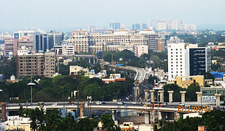
Greater Chennai Metropolitan Area, or simply the Chennai Metropolitan Area (CMA), is fourth-most populous metropolitan area in India and the 35th most populous in the world. The CMA consists of the core city of Chennai, which is coterminous with the Chennai district, and its suburbs in Kanchipuram, Chengalpattu, Thiruvallur and Ranipet districts contributes to 27% of States GDP. The Chennai Metropolitan Development Authority (CMDA) is the nodal agency that handles town planning and development within the metro area. In 1974, an area encompassing 1,189 km2 (459 sq mi) around the city was designated as the metropolitan area which was subsequently expanded to 5,904 km2 (2,280 sq mi) in 2022. Oxford Economics Global Cities Index 2024 ranked Chennai as the 4th best city in India and 472nd best city in the world.

The economy of the state of Maharashtra is the largest in India. Maharashtra is India's second most industrialised state contributing 20% of national industrial output. Almost 46% of the GSDP is contributed by industry. Maharashtra has software parks in many cities around the state, and is the second largest exporter of software with annual exports over ₹ 80,000 crores.

The Outer Ring Road, officially known as Nehru Outer Ring Road and abbreviated as, O.R.R., is a 158-kilometre (98 mi), eight-lane ring road expressway encircling Hyderabad, capital of the Indian state of Telangana. The expressway was designed for speeds up to 100 kilometres per hour (62 mph), later increased to 120 kilometres per hour (75 mph). A large part, 124 kilometres (77 mi) of the 158 kilometres (98 mi) was opened by December 2012.
Nagpur Municipal Corporation (NMC) is the municipal body administering Nagpur, in Maharashtra state in Central India.
The city of Nagpur is strategically located in central India. It has a vast railway network and its road network is well-maintained to avoid congestion. There are 4 modes of transportation in Nagpur. Nagpur is connected to India's four major metropolitan areas by road, rail and air. Auto rickshaws operate in most parts of the city, and are the main form of hired transport.

Nagpur Improvement Trust (NIT) (Marathi: नागपूर सुधार प्रन्यास [नासुप्र]) is an urban development authority with the task of developing new areas within the city limits of Nagpur, India and maintaining existing city infrastructure. This trust works along with Nagpur Municipal Corporation (NMC) which is an elected body of city representatives (Corporation). NIT itself is not a democratically elected civic body and has members appointed in it from various levels like Government of Maharashtra, NMC and other representatives of Nagpur. NIT thus has a small management body as compared to NMC. NIT holds the planning and development authority for Nagpur but does not receive any funds from state government. Funds needed for development work are raised by NIT through the auction of newly developed areas.
The Hyderabad Metropolitan Development Authority (HMDA) is the urban planning agency of Hyderabad in the Indian state of Telangana. The HMDA administers the Hyderabad Metropolitan Region, spread over an area of 7,257 km2 (2,802 sq mi) and covers the districts of Hyderabad district, Medchal district, part of Rangareddy district, Bhuvanagiri district, Sangareddy district, Medak district and Siddipet district. HMDA is the largest urban development authority in India. HMDA was formed by the merging of the following erstwhile entities: Hyderabad Urban Development Authority (HUDA), Hyderabad Airport Development Authority (HADA), Cyberabad Development Authority (CDA) and Buddha Poornima Project Authority (BPPA). HMDA was set up for the purposes of planning, co-ordination, supervising, promoting and securing the planned development of the Hyderabad Metropolitan Region. It coordinates the development activities of the municipal corporations, municipalities and other local authorities, the Hyderabad Metropolitan Water Supply & Sewerage Board, the Telangana State Transmission Corporation, the Telangana State Infrastructure Corporation.

The Maharashtra State Road Development Corporation Limited, commonly abbreviated as MSRDC, is an Indian public limited company fully owned by the Government of Maharashtra. MSRDC was established on 9 July 1996 and incorporated as a public limited company under the Companies Act 1956 on 2 August 1996. It is responsible for developing, building and maintaining roads in Maharashtra.

Pune Metropolitan Region (PMR) is the metropolitan region around the city of Pune. According to practical purposes, PMR comprises two Municipal Corporations of PMC, PCMC and three Cantonment Boards, spread over an area of 7,256.46 km2. The population of the region as per 2011 census was 7,541,946. It Contributes 80% GDP to Pune District and 9.2% GDP to Maharashtra.
Maharashtra Airport Development Company Limited abbreviated as (MADC), is a Special Purpose Company constituted in 2002 by the Government of Maharashtra (GoM) to plan, construct, operate and maintain airports in the State. The government has entrusted MADC the task of developing three `greenfield' and six `brownfield' airports, and a heliport at Gadchiroli. MADC was also to play a lead role in the planning and implementation of the Multi-modal International Cargo Hub and Airport at Nagpur (MIHAN) project,
The Nagpur metropolitan area or Greater Nagpur is a metropolitan area in Indian state of Maharashtra.
The Mumbai Metropolitan Region Development Authority (MMRDA) is a body of the Government of Maharashtra that is responsible for preparation of Regional Plan for MMR and the infrastructure development of the Mumbai Metropolitan Region. The MMRDA was created on 26 January 1975 under the Mumbai Metropolitan Region Development Authority Act, 1974 Government of Maharashtra. The agency is responsible for planning and coordination of development activities in the Region.
The Greater Nashik Metro or Metro NEO is a proposed rapid transit system in the Nashik Metropolitan Region. The system is proposed to reduce traffic congestion as well as provide direct connectivity to Nashik city from its suburbs. The Greater Nashik Metro will connect suburbs of Nashik city like Deolali, Nashik Road, Upnagar, Nashik Airport, Sinnar, Igatpuri, Gangapur Road, Trimbakeshwar, Dindori, Bhagur, Niphad, Adgaon, Ghoti Budruk and Girnare.
Maharashtra is a state in western India. It is the country's second-most-populous state and third-largest state by area. Maharashtra is bordered by the Arabian Sea on the west, Gujarat and the Union territory of Dadra and Nagar Haveli on the northwest, Madhya Pradesh on the north and northeast, Chhattisgarh on the east, Karnataka on the south, Telangana on the southeast and Goa on the southwest. The state covers 307,731 km2 (118,816 sq mi), or 9.84 percent of India's total area.
Pune Metropolitan Region Development Authority is the planning and development authority for the Pune Metropolitan Region. It was notified in the year 2015 and has a jurisdictional area of 7,256.46 km2 (2,801.73 sq mi) with a population of 7.276 million (approximately), it is the 2nd largest urban unit in Maharashtra.
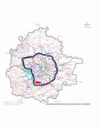
Hyderabad Metropolitan Region is the metropolitan area covered by the city of Hyderabad in the Indian state of Telangana. The entire region is spread over the districts of Hyderabad District, Bhuvanagiri, Medchal-Malkajgiri, Ranga Reddy, Sangareddy, Medak, and Siddipet. Under the jurisdiction of Hyderabad Metropolitan Development Authority, it covers an area of 7,257 km2 (2,802 sq mi) and has a population of 10.7 million people.
Nashik Metropolitan Region Development Authority (NMRDA) is the Planning and Development Authority for the Nashik Metropolitan Region. It was notified in the year 2018, making an urban unit in Maharashtra. NMRDA covers, Nashik city,entire Talukas of Nashik, Niphad, Sinnar, Dindori, Igatpuri, and Trimbakeshwar. NMRDA has been set up as a legally empowered and a self-financing corporate body by the Urban Development Department of the Government of Maharashtra.
References
- ↑ Ganjapure, Vaibhav (14 June 2018). "HC stays govt's move to dissolve NIT". Times of India. Retrieved 10 October 2018.
| | This article about government in India is a stub. You can help Wikipedia by expanding it. |