
Little Traverse Township is a civil township of Emmet County in the U.S. state of Michigan. The population was 2,426 at the 2000 census.

Jesus Maria is an unincorporated community in Calaveras County, California. It lies at an elevation of 1043 feet and is located at 38°17′08″N120°38′51″W. The community is in ZIP code 95222 and area code 209.
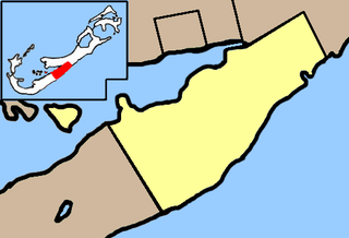
Hinson's Island is a small island within the Great Sound, Bermuda of Bermuda. It lies in the southeast of the sound, and is part of Paget parish, although it was formerly part of Warwick Parish and is still within the Warwick North constituency.

The BYU Centennial Carillon is a carillon on the campus of Brigham Young University (BYU) in Provo, Utah. The bell tower was erected in 1975 to commemorate the one hundredth anniversary of the school's founding. Built in a simple, modern style designed by architect Fred L. Markham, it stands 97 feet tall and contains 52 bells. The bells range in size from 25 lbs to 4,730 lbs. The carillon tolls a tune based on the hymn "Come, Come, Ye Saints," followed by the hour, and tolls a chime on the half-hour. The hour and half-hour strikes are controlled by an automated system. Carillonneurs may also play the instrument by means of a keyboard located directly below the belfry, in a small room reached by a spiral staircase that ascends through the center of the tower.
Clendinning Provincial Park is a provincial park in British Columbia, Canada. It surrounds the drainage of Clendinning Creek, which is a tributary of the Elaho River. Its name is shared by the Clendinning Range, of which Mount Clendinning is the highest summit.
Drewry Point Provincial Park is a provincial park in British Columbia, Canada on the west side of Kootenay Lake, southeast of the city of Nelson.
High Lakes Basin Provincial Park is a provincial park in British Columbia, Canada.
Jackman Flats Provincial Park is a provincial park in British Columbia, Canada, comprising approximately 615 ha. and located just southeast of Tête Jaune Cache in the Rocky Mountain Trench, near the Yellowhead Pass. The park features several hiking trails.
Spatsizi Plateau Wilderness Provincial Park is a provincial park in British Columbia, Canada, protecting most of the Spatsizi Plateau, the southeasternmost subplateau of the Stikine Plateau, and the upper reaches of the basin of the Stikine River.
Magaz de Pisuerga is a municipality located in the province of Palencia, Castile and León, Spain. According to the 2004 census (INE), the municipality has a population of 755 inhabitants.
Coochieville is an unincorporated community in Accomack County, Virginia, United States.
Yale First Nation is a First Nations government located at Yale, British Columbia. Yale has 16 distinct reserves stretching from near Sawmill Creek to American Creek, with the most southern reserve situated at Ruby Creek in the District of Kent.

Forte da Salga is a fort in the Azores. It is located in Angra do Heroísmo, on the island of Terceira.
St. Hebron is a small unincorporated community in Gadsden County, Florida, United States, which borders St. John, Scottown and Havana. St. Hebron, along with its neighboring communities, is located on the outside of the city limits of Quincy, between Quincy and Havana.
Sebree Station is the informal name given to a group of three coal-fired power plants co-located together in the northeast corner of Webster County, near Sebree, Kentucky. They are owned and operated by the Big Rivers Electric Corporation.
Burnsville is an unincorporated community in Bath County, Virginia, in the United States.
Donnelley Wildlife Management Area or Donnelley WMA is an undeveloped 8,048-acre (32.57 km2) natural area in Colleton County, South Carolina near the unincorporated area of Green Pond. Named after Gaylord and Dorothy Donnelley who were instrumental in leading land preservation efforts in the ACE Basin, Donnelley WMA is owned private individuals and managed by scdnr.
Washington Mills is an unincorporated community in Greene County, in the U.S. state of Ohio.

Sol is a ward (barrio) of Madrid belonging to the district of Centro.


