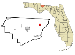
Town of Havana | |
---|---|
Havana, Florida | |
Motto(s): "Florida's Friendliest Small Town!" "A Great Place to Live!" | |
Coordinates: 30°37′27″N84°24′54″W / 30.62417°N 84.41500°W | |
Country | United States |
State | Florida |
County | Gadsden |
Incorporated | December 5, 1906 [1] [2] |
Named for | Havana, Cuba |
Government | |
• Type | Council-Manager |
• Mayor | Tim Loughmiller, Jr. |
• Mayor Pro Tem | Eddie Bass |
• Council Members | Lawrence Reed, Matthew Wesolowski, Tabatha Nelson, Landon Seymour, and Penny Key |
• Town Manager | Kendrah Wilkerson |
• Town Clerk | Shrylan Reena Alexander |
Area | |
• Total | 2.83 sq mi (7.32 km2) |
• Land | 2.79 sq mi (7.22 km2) |
• Water | 0.04 sq mi (0.10 km2) |
Elevation | 236 ft (72 m) |
Population (2020) | |
• Total | 1,753 |
• Density | 629.22/sq mi (242.92/km2) |
Time zone | UTC-5 (Eastern (EST)) |
• Summer (DST) | UTC-4 (EDT) |
ZIP code | 32333 |
Area code | 850 |
FIPS code | 12-29150 [4] |
GNIS feature ID | 0283812 [5] |
Website | www |
Havana is a town in Gadsden County, Florida, United States, and a suburb of Tallahassee. [6] The population was 1,753 at the 2020 census, [7] almost even from 1,754 at the 2010 census. It is part of the Tallahassee, Florida Metropolitan Statistical Area. The town was named after Havana, Cuba, located about 530 miles (850 km) to the south. [8]
The cultivation of shade tobacco began in Gadsden County, Florida around 1829. In 1902, following the completion of the Georgia, Florida and Alabama Railroad, many settlers moved a mile east to the present site of Havana. A local teacher, James Mathewson, proposed the name "Havana". He believed the hand-rolled cigars made in this region of Florida were comparable to those from Havana, Cuba. On December 5, 1906, the Town of Havana was officially incorporated. The railway town was important to the export of farming and tobacco. [1] [2]
On March 16, 1916, Havana was destroyed by a fire and 26 business-owned buildings were burned leaving only two remaining stores. [1] [2]
In recent times, much of the tobacco crop industry has declined and Havana is now known for its antiques, art galleries and specialty stores.
The approximate coordinates for the Town of Havana is located in northeastern Gadsden County on the Florida Panhandle at 30°37′27″N84°24′54″W / 30.62417°N 84.41500°W (30.624245, –84.414955). [9]
U.S. Route 27 passes through the center of town, leading southeast 16 miles (26 km) to the center of Tallahassee and north 25 miles (40 km) to Bainbridge, Georgia. Florida State Road 12 intersects US 27 in Havana; it leads west 12 miles (19 km) to Quincy, the Gadsden County seat.
According to the United States Census Bureau, Havana has a total area of 2.8 square miles (7.2 km2), of which 0.02 square miles (0.04 km2), or 0.57%, is water.
The climate in this area is characterized by hot, humid summers and generally mild winters. According to the Köppen climate classification, the Town of Havana has a humid subtropical climate zone (Cfa).
Climate data for Havana, Florida | |||||||||||||
---|---|---|---|---|---|---|---|---|---|---|---|---|---|
Month | Jan | Feb | Mar | Apr | May | Jun | Jul | Aug | Sep | Oct | Nov | Dec | Year |
Record high °F (°C) | 83 (28) | 85 (29) | 90 (32) | 92 (33) | 100 (38) | 102 (39) | 102 (39) | 101 (38) | 98 (37) | 95 (35) | 87 (31) | 84 (29) | 102 (39) |
Mean daily maximum °F (°C) | 64 (18) | 67 (19) | 74 (23) | 79 (26) | 86 (30) | 90 (32) | 91 (33) | 90 (32) | 88 (31) | 81 (27) | 73 (23) | 66 (19) | 79 (26) |
Mean daily minimum °F (°C) | 40 (4) | 42 (6) | 48 (9) | 52 (11) | 61 (16) | 68 (20) | 71 (22) | 70 (21) | 66 (19) | 57 (14) | 49 (9) | 42 (6) | 56 (13) |
Record low °F (°C) | 4 (−16) | 0 (−18) | 19 (−7) | 31 (−1) | 36 (2) | 49 (9) | 60 (16) | 59 (15) | 48 (9) | 33 (1) | 20 (−7) | 12 (−11) | 0 (−18) |
Average precipitation inches (mm) | 4.80 (122) | 4.92 (125) | 5.86 (149) | 3.68 (93) | 5.04 (128) | 5.92 (150) | 7.36 (187) | 6.78 (172) | 4.15 (105) | 4.11 (104) | 3.51 (89) | 3.77 (96) | 59.9 (1,520) |
[ citation needed ] |
Census | Pop. | Note | %± |
---|---|---|---|
1910 | 432 | — | |
1920 | 448 | 3.7% | |
1930 | 1,169 | 160.9% | |
1940 | 1,221 | 4.4% | |
1950 | 1,634 | 33.8% | |
1960 | 2,090 | 27.9% | |
1970 | 2,022 | −3.3% | |
1980 | 2,782 | 37.6% | |
1990 | 1,654 | −40.5% | |
2000 | 1,713 | 3.6% | |
2010 | 1,754 | 2.4% | |
2020 | 1,753 | −0.1% | |
U.S. Decennial Census [10] |
Race / Ethnicity (NH = Non-Hispanic) | Pop 2010 [11] | Pop 2020 [12] | % 2010 | % 2020 |
---|---|---|---|---|
White (NH) | 775 | 715 | 44.18% | 40.79% |
Black or African American (NH) | 937 | 899 | 53.42% | 51.28% |
Native American or Alaska Native (NH) | 2 | 0 | 0.11% | 0.00% |
Asian (NH) | 8 | 4 | 0.46% | 0.23% |
Pacific Islander or Native Hawaiian (NH) | 0 | 0 | 0.00% | 0.00% |
Some other race (NH) | 0 | 2 | 0.00% | 0.11% |
Mixed race or Multiracial (NH) | 8 | 58 | 0.46% | 3.31% |
Hispanic or Latino (any race) | 24 | 75 | 1.37% | 4.28% |
Total | 1,754 | 1,753 | 100.00% | 100.00% |
As of the 2020 United States census, there were 1,753 people, 970 households, and 708 families residing in the town. [13]
As of the 2010 United States census, there were 1,754 people, 703 households, and 411 families residing in the town. [14]
As of the census [4] of 2000, there were 1,713 people, 700 households, and 471 families residing in the town. The population density was 922.5 inhabitants per square mile (356.2/km2). There were 762 housing units at an average density of 410.4 per square mile (158.5/km2). The racial makeup of the town was 41.86% White, 56.74% African American, 0.06% Asian, 0.82% from other races, and 0.53% from two or more races. Hispanic or Latino of any race were 1.23% of the population.
In 2000, there were 700 households, out of which 26.7% had children under the age of 18 living with them, 41.1% were married couples living together, 20.6% had a female householder with no husband present, and 32.6% were non-families. 28.1% of all households were made up of individuals, and 14.9% had someone living alone who was 65 years of age or older. The average household size was 2.43 and the average family size was 2.96.
In 2000, in the town, the population was spread out, with 22.9% under the age of 18, 8.5% from 18 to 24, 25.3% from 25 to 44, 25.2% from 45 to 64, and 18.2% who were 65 years of age or older. The median age was 40 years. For every 100 females, there were 83.2 males. For every 100 females age 18 and over, there were 79.5 males.
In 2000, the median income for a household in the town was $27,344, and the median income for a family was $38,487. Males had a median income of $25,000 versus $19,958 for females. The per capita income for the town was $18,481. About 11.1% of families and 16.3% of the population were below the poverty line, including 18.3% of those under age 18 and 23.0% of those age 65 or over.
The Gadsden County School District operates Havana Magnet School, which serves elementary and middle school grades. Gadsden County High School (formerly East Gadsden High School), outside of the city limits, is the only zoned high school in the county.
Previously the Havana area had three schools: Havana Elementary School, Havana Middle School, and Havana Northside High School. [15] Havana Elementary began using the Accelerated School program in Spring 1995 in order to improve academic performance. In 2001, Havana Elementary, which occupied an 18-acre (7.3 ha) area, had about 100 employees and 1,000 students; most of the students were low income, and 95% of the students were from African-American families. [16] In 2003, Havana Northside High School and James A. Shanks High School in Quincy consolidated into East Gadsden High. [17] In 2017, the high school section of West Gadsden High School consolidated into East Gadsden High, leaving the latter as the only remaining zoned high school in the county. [18]
Tallavanna Christian School, a private school, is in an unincorporated area near Havana.
The Gadsden Connector, a bus route operated by Big Bend Transit, has a stop in Havana. [19]
Gadsden County is a county located in the panhandle of the U.S. state of Florida. As of the 2020 census, the population was 43,826. Its county seat is Quincy. Gadsden County is included in the Tallahassee Metropolitan Statistical Area. Gadsden County is the only majority African-American county in Florida.
Davie is a town in Broward County, Florida, United States, approximately 24 miles (39 km) north of Miami. The town's population was 110,320 at the 2020 census, making it the largest town in Florida by population. Davie is a principal town of the Miami metropolitan area. Horseback riding is common, as many of its historic buildings include ranches and other Western establishments.
Chattahoochee is a city in Gadsden County, Florida, United States. Its history dates to the Spanish era. It is part of the Tallahassee, Florida Metropolitan Statistical Area. The population was 2,955 as of the 2020 census, down from 3,652 at the 2010 census.
Greensboro is a town in Gadsden County, Florida, United States. It is part of the Tallahassee Metropolitan Statistical Area. The population was 461 at the 2020 US census, down from 602 at the 2010 US census.
Gretna is a city in Gadsden County, Florida, United States. It is part of the Tallahassee, Florida Metropolitan Statistical Area. The majority of the population is African American, and as of the 2020 census, had 1,357 residents, down from 1,460 at the 2010 census.
Midway is a city in Gadsden County, Florida, United States. It is part of the Tallahassee, Florida Metropolitan Statistical Area. According to the 2020 census, the population was 3,537, up from 3,004 at the 2010 census.
Quincy is a city in and the county seat of Gadsden County, Florida, United States. Quincy is part of the Tallahassee, Florida Metropolitan Statistical Area. The population was 7,970 as of the 2020 census, almost even from 7,972 at the 2010 census.
Jasper is a city and the county seat of Hamilton County, Florida, United States. The population was 3,621 at the 2020 census.
Jennings is a town in Hamilton County, Florida, United States. The population was 749 at the 2020 census, down from 878 at the 2010 census.
Cottondale is a city in Jackson County, Florida, United States. It is part of the Florida Panhandle and North Florida. The population was 848 at the 2020 census, down from 933 at the 2010 census.
Bristol is a city in and the county seat of Liberty County, Florida, United States. It is the only incorporated city in Liberty County. The population was 918 at the 2020 census.
Greenville is a town in Madison County, Florida, United States. The population was 746 at the 2020 census, down from 843 at the 2010 census.
Lee is a town in Madison County, Florida, United States. The Town of Lee is part of the Florida Panhandle in North Florida. The population was 375 at the 2020 census.
Gladeview is a census-designated place (CDP) in Miami-Dade County, Florida, United States. It is part of the Miami metropolitan area of South Florida. The population was 14,927 at the 2020 census, up from 11,535 in 2010.
Naranja is an unincorporated community and census-designated place (CDP) in Miami-Dade County, Florida, United States. Many orange groves were once located in this area, so the community name came from the Spanish word for orange, naranja, though the pronunciation among the local residents is "Na-Ran-Jah". Naranja was also a stop for the Florida East Coast Railroad that once ran through this area. It is part of the Miami metropolitan area of South Florida. The population was 13,509 at the 2020 census, up from 8,303 in 2010.
West Little River is a census-designated place (CDP) in Miami-Dade County, Florida, United States. It is part of the Miami metropolitan area of South Florida. The population was 34,128 at the 2020 census.
Duncan is a town in Bolivar County, Mississippi, United States. Per the 2020 census, the population was 276.
Belhaven is a waterfront town in Beaufort County, North Carolina, United States. The population was 1,688 at the 2010 census. Belhaven is located in North Carolina's Inner Banks region.
Cross Mountain is a census-designated place (CDP) in Bexar County, Texas, United States. The population was 3,944 at the 2020 census, an increase over the figure of 3,124 tabulated in 2010. It is part of the San Antonio Metropolitan Statistical Area.
Scenic Oaks is a census-designated place (CDP) in Bexar County, Texas, United States. It is part of the San Antonio Metropolitan Statistical Area. The population was 10,458 at the 2020 census, up from 4,957 at the 2010 census.