History of Kirkstall

Last updated

Kirkstall is a historically important area of Leeds. Its history can be seen in its abbey, its industrial remains and its regeneration.

Contents

Early history

Kirkstall was historically an important centre of industry. Kirkstall Forge lays claim to being the longest continually used industrial site in Britain founded in the 13th century by the Cistercian monks of the abbey, and a number of printers. The earliest known activity on the site was a medieval mill race which supplied water to power the corn mill at Kirkstall Abbey. Iron production took place at the forge from the 1580s onwards.

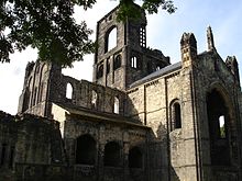
Kirkstall Abbey, a daughter abbey of Fountains was founded in 1152 by Abbot Alexander. [1] By the time of the Reformation the site covered 800 acres. [2] The abbey buildings took over 75 years to build.

Reformation

The ruins of Kirkstall Abbey KirkstallAbbey.JPG
The ruins of Kirkstall Abbey

At the time of the reformation, Kirkstall Abbey covered around 800 acres. The monks in residence produced leather goods, pottery, leadwork as well as being involved in weaving and other forms of metalwork. The Cistercian foundries were well equipped and skilled and it has been likened to a forerunner to the Industrial Revolution. [3]

Under the auspices of the dissolution of the monasteries, Kirkstall Abbey was formerly surrendered on 22 November 1539 by abbot John Ripley. He and 31 monks who gathered in the abbeys chapter house surrendering it to Richard Leyton, a commissioner to Henry VIII. [4]

The abbey was left to ruin and now sits in parkland by the River Aire. The ruins have been painted by artists such as J. M. W. Turner and Thomas Girtin.

English Civil War

During the English Civil War, the bridge over the Aire at Kirkstall (referred to in a contemporaneous account as 'Churchstall') was blown up by Royalist troops from Leeds. After discovering this, a Parliamentary force led by Ferdinando Fairfax, 2nd Lord Fairfax of Cameron – from Otley – had to cross the river upstream at Apperley Bridge before retaking Leeds in January 1643.

Industrial Revolution

The entrance to the now disused Kirkstall Forge Kirkstall Forge entrance from Abbey Road, Hawksworth - geograph.org.uk - 130125.jpg
The entrance to the now disused Kirkstall Forge

Kirkstall's position on the River Aire made it a prominent place for industrial development in the early Industrial Revolution. A water power system was constructed on the River Aire below Kirkstall Abbey between 1760 and 1860; remains of this can still be seen today. [5]

Construction of the Leeds and Liverpool Canal began in 1770, bringing greater transport links to Kirkstall, further increasing its attractiveness to industry. An array of industries developed including brewing, printing, textiles and iron forging.

Railway lines later opened to both the east and west of Kirkstall.

St. Ann's Mill, a mill manufacturing cashmere, opened in 1822 while J.E. Brooke, a woollen mill, opened in 1830. [6]

Kirkstall's brewery was first registered in 1871 and its original building remains, albeit as student flats (the current brewery operates from premises nearby).

Kirkstall Forge continued to grow throughout this period. During the late 18th century, the reconstruction of the upper and lower forges allowed 'shovel and spade production' to commence. A railway was built at the forge in 1830 and sustained growth at the plant.

20th century

The First World War brought about large scale growth, providing axles for military vehicles and by 1930 most lorries and buses made in the UK had a Kirkstall back axle casing. In 2002 the owners of the site, the Dana announced the closure of the works, shifting production to India and Spain. [7] The site is undergoing major redevelopment, as is the old Waide's Printers & Kwik Save site. Printing has, like iron-founding, suffered a decline, several printing companies remain. Until the late 1970s when it was closed, Kirkstall was dominated by a coal fired power station. It was replaced by larger power stations away from town at Ferrybridge, Eggborough and Drax. The power station was demolished in the early 1980s.

Regeneration

The regeneration of Kirkstall and the surrounding valley began in the 1980s and continues today.

Past

The Kirkstall Valley and (in nearby Burley) Cardigan Fields retail parks was born out of at attempt to regenerate Kirkstall beginning in the 1980s. Much of the proposed regenerations never took place and many were held in contempt by residents such as the initially proposed 'dinosaur theme park'. Other features never to be built include a marina, shopping centres (although similar developments were built) and office developments [8] [9]

The nature of the Kirkstall area has often stalled development plans; with the area being divided by a railway, the River Aire and the Leeds Liverpool Canal, as well as the existence of a number of high-voltage power lines have presented developers with challenges not present at other sites. [10]

Current

Currently the redevelopment of Kirkstall Forge which closed in 2002 involves the building of residential and commercial premises as well as the opening of Kirkstall Forge railway station. The redeveloped Kirkstall Forge will include over 1,000 new homes of varying types, as well as 150,000 square feet of space for offices and amenities. A hotel will also be built on site. This scheme is cited to create 3,000 new jobs. [11] [12]

The commercial centre of Kirkstall is somewhat dilapidated and it has been proposed by Tesco to redevelop this area. A supermarket, other shops and new premises for the Leeds Postal Workers Sports Association club are included in the plans. The former Kirkstall Lites pub and Kirkstall Liberal Club will be demolished along with the existing shopping centre. [13]

A new park in the Kirkstall Valley has also been proposed. [14]

The current regeneration of Kirkstall is laid down in the Aire Valley Action Plan. [15]

Related Research Articles

<span class="mw-page-title-main">Kirkstall Abbey</span> Cistercian monastery in West Yorkshire, England

Kirkstall Abbey is a ruined Cistercian monastery in Kirkstall, north-west of Leeds city centre in West Yorkshire, England. It is set in a public park on the north bank of the River Aire. It was founded c. 1152. It was disestablished during the Dissolution of the Monasteries under Henry VIII.

<span class="mw-page-title-main">West Yorkshire</span> County of England

West Yorkshire is a metropolitan and ceremonial county in the Yorkshire and the Humber region of England. It borders North Yorkshire to the north and east, South Yorkshire and Derbyshire to the south, Greater Manchester to the south-west, and Lancashire to the west. The city of Leeds is the largest settlement.

<span class="mw-page-title-main">River Aire</span> River in Yorkshire, England

The River Aire is a major river in Yorkshire, England, 92 miles (148 km) in length. Part of the river below Leeds is canalised, and is known as the Aire and Calder Navigation.

<span class="mw-page-title-main">Kirkstall</span> Suburb of Leeds, West Yorkshire, England

Kirkstall is a north-western suburb of Leeds, West Yorkshire, England, on the eastern side of the River Aire. The area sits in the Kirkstall ward of Leeds City Council and Leeds Central and Headingley parliamentary constituency, represented by Alex Sobel. The population of the ward at the 2011 Census was 21,709.

<span class="mw-page-title-main">Airedale</span> Valley in North and West Yorkshire, England

Airedale is a valley, or dale, in North Yorkshire and West Yorkshire, England. It is named after the River Aire, which flows through it. The upper valley, from Malham Cove to Airton, is known as Malhamdale, named after the village of Malham. At Airton the valley widens and becomes Airedale proper. The river flows past Skipton on to Keighley, Bingley, Shipley, and Leeds.

<span class="mw-page-title-main">Barnoldswick</span> Town and civil parish in Lancashire, England

Barnoldswick is a market town and civil parish in the Borough of Pendle, Lancashire, England. It lies within the boundaries of the historic West Riding of Yorkshire. It is situated 30 miles (48 km) from Leeds; nearby towns include Skipton to the east, Clitheroe to the west, Burnley to the south and Keighley to the east-south-east. The civil parish has a population of 10,752.

<span class="mw-page-title-main">Horsforth</span> Town and civil parish in West Yorkshire, England

Horsforth is a town and civil parish in the City of Leeds, West Yorkshire, England, five miles north-west of Leeds city centre. Historically a village within the West Riding of Yorkshire, it had a population of 18,895 at the 2011 Census. It became part of the City of Leeds metropolitan borough in 1974. In 1999, a civil parish was created for the area, and the parish council voted to rename itself a town council. The area is within the Horsforth ward of Leeds City Council, which also includes the southern part of Rawdon.

<span class="mw-page-title-main">Hunslet</span> Suburb of Leeds, West Yorkshire, England

Hunslet is an inner-city suburb in south Leeds, West Yorkshire, England. It is 1 mile (1.6 km) southeast of the city centre and has an industrial past.

<span class="mw-page-title-main">Hawksworth, Leeds</span> Human settlement in England

Hawksworth is a small, early twentieth-century council estate in the Kirkstall ward in Leeds, West Yorkshire, England.

<span class="mw-page-title-main">Wharfedale line</span> Railway line in England

The Wharfedale line is one of the rail services in the West Yorkshire Metro area of northern England. The service connects Ilkley with Leeds and Bradford, and is operated by Northern Trains. West Yorkshire Metrocards are available for use on the line, covering Zones 3–5. The line is served predominantly by four-coach Class 333 electric multiple units.

<span class="mw-page-title-main">Abbey Light Railway</span>

The Abbey Light Railway was a 2 ft narrow gauge railway in Kirkstall, Leeds, West Yorkshire, England. Built by enthusiasts, the Railway ran from the nearby Bridge Road commercial area into the grounds of Kirkstall Abbey, operating most Sundays.

<span class="mw-page-title-main">Burley, Leeds</span> Area of Leeds, West Yorkshire, England

Burley is an inner city area of Leeds, West Yorkshire, England, 1 mile (1.6 km) north-west of Leeds city centre, between the A65 Kirkstall Road at the south and Headingley at the north, in the Kirkstall ward.

<span class="mw-page-title-main">Leeds Industrial Museum at Armley Mills</span>

The Leeds Industrial Museum at Armley Mills is a museum of industrial heritage located in Armley, near Leeds, in West Yorkshire, Northern England. The museum includes collections of textile machinery, railway equipment and heavy engineering amongst others.

<span class="mw-page-title-main">Greenwood & Batley</span>

Greenwood & Batley were a large engineering manufacturer with a wide range of products, including armaments, electrical engineering, and printing and milling machinery. They also produced a range of battery-electric railway locomotives under the brand name Greenbat. The works was in Armley, Leeds, UK.

<span class="mw-page-title-main">Kirkstall Power Station</span> Former coal-fired power station in Leeds, England

Kirkstall Power Station was a coal-fired unit opened in 1930, serving the city of Leeds, West Yorkshire, England.

<span class="mw-page-title-main">Kirkstall Forge</span>

Kirkstall Forge is a 57-acre mixed-use development located in Kirkstall in Leeds, West Yorkshire. The site is one of the oldest most continuously used industrial sites in England. It was operated by Kirkstall Forge Engineering, a metalworking business. It was a working forge until 1995 when the site was bought by Commercial Estates Group who have had plans approved to build 1,050 homes, 300,000 sq ft of office space, 100,000 sq ft of leisure and retail and a primary school. In June 2016 a railway station was opened on the site served by trains between Leeds and Bradford.

<span class="mw-page-title-main">Kirkstall Road Viaduct</span> Railway viaduct in West Yorkshire, England

Kirkstall Road Viaduct is a Grade II listed railway viaduct carrying the Harrogate line over the A65 Kirkstall Road, the River Aire, and the Leeds and Liverpool Canal in Burley, Leeds, West Yorkshire. It was built in 1849 by the engineer Thomas Grainger for the Leeds and Thirsk Railway. The viaduct, which is approximately 440 m (0.27 mi), is a significant local landmark due to the wide, shallow nature of the valley it crosses.

Kirkstall is a ward in the metropolitan borough of the City of Leeds, West Yorkshire, England. It contains 48 listed buildings that are recorded in the National Heritage List for England. Of these, one is listed at Grade I, the highest of the three grades, two are at Grade II*, the middle grade, and the others are at Grade II, the lowest grade. The ward contains Kirkstall, Burley and Hawksworth, all suburbs of Leeds. The River Aire and the Leeds and Liverpool Canal pass through the ward, and the listed buildings associated with these are weirs, sluices, locks, and a canal bridge. The most important building is the ward is Kirkstall Abbey, which is listed, together with associated structures. The other listed buildings include houses and associated structures, churches and items in churchyards, public houses, a school and a former Sunday school, a commemorative arch, road bridges, a railway viaduct and station, former mill buildings, buildings associated with a former forge, and a war memorial.

<span class="mw-page-title-main">Newlay</span> Suburb of Horsforth, West Yorkshire, England

Newlay is a suburb of Horsforth, in West Yorkshire, England. Originally a hamlet, it is now part of Horsforth parish in the City of Leeds District, and has its own conservation area. Newlay is situated on the Leeds and Liverpool Canal and the River Aire, some 5 miles (8 km) north west of Leeds city centre.

References

  1. http://www.kirkstall.org.uk/abbey/abbeyhistory.html Archived 24 December 2012 at archive.today paragraph 1
  2. http://www.kirkstall.org.uk/abbey/abbeyhistory.html Archived 24 December 2012 at archive.today paragraph 2
  3. http://www.kirkstall.org.uk/abbey/abbeyhistory.html Archived 24 December 2012 at archive.today paragraph 7
  4. http://www.kirkstall.org.uk/abbey/abbeyhistory.html Archived 24 December 2012 at archive.today paragraph 8
  5. http://www.kirkstallward.net/history/index.htm paragraph 1
  6. Low resolution copy of the drawings for Brooke & Hargraves 1825 patent specification
  7. "Developer seeks big corporate name for office plan". The Yorkshire Post. 10 June 2010. Retrieved 4 November 2017.
  8. http://www.illo.demon.co.uk/intro.htm Archived 8 March 2012 at the Wayback Machine paragraph 7
  9. http://www.illo.demon.co.uk/intro.htm Archived 8 March 2012 at the Wayback Machine map
  10. http://www.illo.demon.co.uk/intro.htm Archived 8 March 2012 at the Wayback Machine paragraph 7
  11. "Kirkstall Forge | New Neighbourhood in Leeds | Modern offices".
  12. "'Join my campaign to save Kirkstall Forge station' – MP". The Guardian . 27 July 2010.
  13. "New consultation dates for Kirkstall flood defenses | KIRKSTALL ONLINE".
  14. "Feasibility Studies".
  15. "Aire Valley Leeds Area Action Plan Adoption".