
The Colorado River is one of the principal rivers in the Southwestern United States and in northern Mexico. The 1,450-mile-long (2,330 km) river, the 5th longest in the United States, drains an expansive, arid watershed that encompasses parts of seven U.S. states and two Mexican states. The name Colorado derives from the Spanish language for "colored reddish" due to its heavy silt load. Starting in the central Rocky Mountains of Colorado, it flows generally southwest across the Colorado Plateau and through the Grand Canyon before reaching Lake Mead on the Arizona–Nevada border, where it turns south toward the international border. After entering Mexico, the Colorado approaches the mostly dry Colorado River Delta at the tip of the Gulf of California between Baja California and Sonora.

Rainbow Bridge is a natural arch in southern Utah, United States. With a span of 275 feet (84 m), as reported in 1974 by the Bureau of Reclamation, and height of 290 feet (88 m), it is one of the largest natural arches in the world. At the top it is 42 feet (13 m) thick and 33 feet (10 m) wide. The bridge, which is of cultural importance to a number of area Native American tribes, has been designated a Traditional Cultural Property by the National Park Service. Rainbow Bridge National Monument was protected in 1910, and it is administered by Glen Canyon National Recreation Area.

Glen Canyon Dam is a concrete arch-gravity dam in the southwestern United States, located on the Colorado River in northern Arizona, near the city of Page. The 710-foot-high (220 m) dam was built by the Bureau of Reclamation (USBR) from 1956 to 1966 and forms Lake Powell, one of the largest man-made reservoirs in the U.S. with a capacity of more than 25 million acre-feet (31 km3). The dam is named for Glen Canyon, a series of deep sandstone gorges now flooded by the reservoir; Lake Powell is named for John Wesley Powell, who in 1869 led the first expedition to traverse the Colorado River's Grand Canyon by boat.
Lake Powell is a reservoir on the Colorado River in Utah and Arizona, United States. It is a major vacation destination visited by approximately two million people every year. It holds 24,322,000 acre-feet (3.0001×10¹⁰ m3) of water when full, second in the United States to only Lake Mead - though Lake Mead has fallen below Lake Powell in size several times during the 21st century in terms of volume of water, depth and surface area.

The Green River, located in the western United States, is the chief tributary of the Colorado River. The watershed of the river, known as the Green River Basin, covers parts of the U.S. states of Wyoming, Utah, and Colorado. The Green River is 730 miles (1,170 km) long, beginning in the Wind River Mountains of Wyoming and flowing through Wyoming and Utah for most of its course, except for a short segment of 40 miles (64 km) in western Colorado. Much of the route traverses the arid Colorado Plateau, where the river has carved some of the most spectacular canyons in the United States. The Green is slightly smaller than Colorado when the two rivers merge but typically carries a larger load of silt. The average yearly mean flow of the river at Green River, Utah is 6,121 cubic feet (173.3 m3) per second.

Lees Ferry is a site on the Colorado River in Coconino County, Arizona in the United States, about 7.5 miles (12.1 km) southwest of Page and 9 miles (14 km) south of the Utah–Arizona state line.

The Dirty Devil River is an 80-mile-long (130 km) tributary of the Colorado River, located in the U.S. state of Utah. It flows through southern Utah from the confluence of the Fremont River and Muddy Creek before emptying into the Colorado River at Lake Powell.

Navajo Bridge is the name of twin steel spandrel arch bridges that cross the Colorado River in the Grand Canyon National Park in northern Coconino County, Arizona, United States. The newer of the two spans carries vehicular traffic on U.S. Route 89A (US 89A) over Marble Canyon between Bitter Springs and Jacob Lake, allowing travel into a remote Arizona Strip region north of the Colorado River including the North Rim of Grand Canyon National Park.
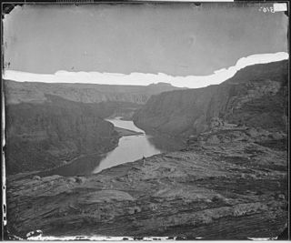
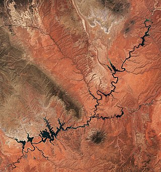
Glen Canyon is a natural canyon carved by a 169.6-mile (272.9 km) length of the Colorado River, mostly in southeastern and south-central Utah, in the United States. Glen Canyon starts where Narrow Canyon ends, at the confluence of the Colorado River and the Dirty Devil River. A small part of the lower end of Glen Canyon extends into northern Arizona and terminates at Lee's Ferry, near the Vermilion Cliffs. Like the Grand Canyon farther downstream, Glen Canyon is part of the immense system of canyons carved by the Colorado River and its tributaries.

Horseshoe Bend is a horseshoe-shaped incised meander of the Colorado River located near the town of Page, Arizona, United States. It is also referred to as the "east rim of the Grand Canyon."

State Route 95 or Bicentennial Highway is a state highway located in the southeast of the U.S. state of Utah. The highway is an access road for tourism in the Lake Powell and Cedar Mesa areas, notably bisecting Bears Ears National Monument and providing the only access to Natural Bridges National Monument. The highway does not serve any cities, but the small town of Hanksville is its western terminus. Although the highway has existed since the 1930s as a primitive dirt road, it received its name at its dedication as a paved state highway coincident with the U.S. Bicentennial in 1976. The highway forms part of the Trail of the Ancients National Scenic Byway.
State Route 276 is a state highway in remote portions of San Juan County, eastern Garfield County, and Kane County, in the southeast of the U.S. state of Utah. The route is used as an access to Lake Powell, serving the small resort towns of Ticaboo and Bullfrog. Historically, SR-276 crossed Lake Powell via the Charles Hall Ferry, the only auto ferry in the state of Utah; however, the ferry is currently out of service due to low water levels. The entire route is part of the Trail of the Ancients National Scenic Byway. Lake Powell separates the route into two sections; the eastern section was numbered State Route 263 prior to the existence of the ferry.

Silver Canyon is a novel written by Louis L'Amour set in south-central Utah Territory in 1881. It was originally published in a shorter version, named Riders of the Dawn, in the magazine Giant Western in June 1951. It then was published in hardback in 1956 by Avalon Books and in paperback by Bantam Books in 1957.

The humpback chub is a federally protected fish that lived originally in fast waters of the Colorado River system in the United States. This species takes its name from the prominent hump between the head and dorsal fin, which is thought to direct the flow of water over the body and help maintain body position in the swift currents of the Colorado river. The body is almost entirely scaleless, retaining only about 80 mid-lateral scales along the lateral line. The fish is very streamlined, with a thin caudal peduncle and a deeply forked tail. The back is a light olive gray, the sides silver, and the belly white. The dorsal fin usually has nine rays, and the anal fin 10 or more. Maximum recorded length is 38 cm.

The Emigrant Trail in Wyoming, which is the path followed by Western pioneers using the Oregon, California, and Mormon Trails, spans 400 miles (640 km) through the U.S. state of Wyoming. The trail entered from Nebraska on the eastern border of the state near the present day town of Torrington and exited on the western border near the towns of Cokeville and Afton. An estimated 350,000 to 400,000 settlers traveled on the trail through Wyoming between 1841 and 1868. All three trails follow the same path through most of the state. The Mormon Trail splits at Fort Bridger and enters Utah, while the Oregon and California Trails continue to Idaho.

The Colorado River Storage Project is a United States Bureau of Reclamation project designed to oversee the development of the upper basin of the Colorado River. The project provides hydroelectric power, flood control and water storage for participating states along the upper portion of the Colorado River and its major tributaries.

Historic Hite is a flooded ghost town at the north end of Lake Powell along the Colorado River in western San Juan County, Utah, United States. Lake Powell, and all of its points of interest, are in the Glen Canyon National Recreation Area, managed by the National Park Service and available to the public for recreation. The town existed on land that Lake Powell now covers. Hite was named for Cass Hite, an early settler. The name was transferred to a National Park Recreation Area at the north end of Lake Powell. The Hite Crossing Bridge, near the marina, carries Utah State Route 95 over the Colorado River and connects the area to the north of the lake.

Cataract Canyon is a 46-mile-long (74 km) canyon of the Colorado River located within Canyonlands National Park and Glen Canyon National Recreation Area in southern Utah. It begins at Colorado's confluence with the Green River, and its downstream terminus is the confluence with the Dirty Devil River. The lower half of the canyon is submerged beneath Lake Powell when the lake is at its normal high water elevation of 3,700 feet (1,100 m).

Bridge Canyon Dam, also called Hualapai Dam, was a proposed dam in the lower Grand Canyon of the Colorado River, in northern Arizona in the United States. It would have been located near Bridge Canyon Rapids in an extremely rugged and isolated portion of the canyon, 235 miles (378 km) downstream of Lees Ferry and at the uppermost end of Lake Mead.

The Colorado River is a major river of the western United States and northwest Mexico in North America. Its headwaters are in the Rocky Mountains where La Poudre Pass Lake is its source. Located in north central Colorado it flows southwest through the Colorado Plateau country of western Colorado, southeastern Utah and northwestern Arizona where it flows through the Grand Canyon. It turns south near Las Vegas, Nevada, forming the Arizona–Nevada border in Lake Mead and the Arizona–California border a few miles below Davis Dam between Laughlin, Nevada and Needles, California before entering Mexico in the Colorado Desert. Most of its waters are diverted into the Imperial Valley of Southern California. In Mexico its course forms the boundary between Sonora and Baja California before entering the Gulf of California. This article describes most of the major features along the river.

