
Escalante is a city in central Garfield County, Utah, United States, located along Utah Scenic Byway 12 (SR-12) in the south-central part of the state. As of the 2010 census, 797 people were living in the city.
Lake Powell is an artificial reservoir on the Colorado River in Utah and Arizona, United States. It is a major vacation destination visited by approximately two million people every year. It is the second largest artificial reservoir by maximum water capacity in the United States behind Lake Mead, storing 25,166,000 acre-feet (3.1042×10¹⁰ m3) of water when full. However, Lake Mead has fallen below Lake Powell in size several times during the 21st century in terms of volume of water, depth and surface area.

The Green River, located in the western United States, is the chief tributary of the Colorado River. The watershed of the river, known as the Green River Basin, covers parts of the U.S. states of Wyoming, Utah, and Colorado. The Green River is 730 miles (1,170 km) long, beginning in the Wind River Mountains of Wyoming and flowing through Wyoming and Utah for most of its course, except for a short segment of 40 miles (64 km) in western Colorado. Much of the route traverses the arid Colorado Plateau, where the river has carved some of the most spectacular canyons in the United States. The Green is slightly smaller than Colorado when the two rivers merge but typically carries a larger load of silt. The average yearly mean flow of the river at Green River, Utah is 6,121 cubic feet (173.3 m3) per second.
The Uncompahgre River is a tributary of the Gunnison River, approximately 75 mi (121 km) long, in southwestern Colorado in the United States. Lake Como at 12,215 ft (3723m) in northern San Juan County, in the Uncompahgre National Forest in the northwestern San Juan Mountains is the headwaters of the river. It flows northwest past Ouray, Ridgway, Montrose, and Olathe and joins the Gunnison at Confluence Park in Delta.

Lees Ferry is a site on the Colorado River in Coconino County, Arizona in the United States, about 7.5 miles (12.1 km) southwest of Page and 9 miles (14 km) south of the Utah–Arizona state line.

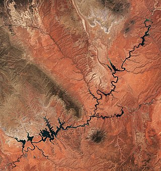
The Escalante River is a tributary of the Colorado River. It is formed by the confluence of Upper Valley and Birch Creeks near the town of Escalante in south-central Utah, and from there flows southeast for approximately 90 miles (140 km) before joining Lake Powell. Its watershed includes the high forested slopes of the Aquarius Plateau, the east slope of the Kaiparowits Plateau, and the high desert north of Lake Powell. It was the last river of its size to be discovered in the 48 contiguous U.S. states. The average discharge is approximately 146 cfs.
The non-existent Buenaventura River, alternatively San Buenaventura River or Río Buenaventura, was once believed to run from the Rocky Mountains to the Pacific Ocean through the Great Basin region of what is now the western United States. The river was chronologically the last of several imagined incarnations of an imagined Great River of the West which would be for North America west of the Rockies what the Mississippi River was east of the Rockies. The hopes were to find a waterway from coast to coast, sparing the traveling around Cape Horn at the tip of South America.
The Paria Canyon-Vermilion Cliffs Wilderness is a 112,500 acres (455 km2) wilderness area located in northern Arizona and southern Utah, United States, within the arid Colorado Plateau region. The wilderness is composed of broad plateaus, tall escarpments, and deep canyons.

Uncompahgre Peak is the sixth highest summit of the Rocky Mountains of North America and the U.S. state of Colorado. The prominent 14,321-foot (4365.0 m) fourteener is the highest summit of the San Juan Mountains and the highest point in the drainage basin of the Colorado River and the Gulf of California. It is located in the Uncompahgre Wilderness in the northern San Juans, in northern Hinsdale County approximately 7 miles (11 km) west of the town of Lake City.

The Southern Paiute people are a tribe of Native Americans who have lived in the Colorado River basin of southern Nevada, northern Arizona, and southern Utah. Bands of Southern Paiute live in scattered locations throughout this territory and have been granted federal recognition on several reservations.

Sevier Lake is an intermittent and endorheic lake which lies in the lowest part of the Sevier Desert, Millard County, Utah. Like Great Salt Lake and Utah Lake, it is a remnant of Pleistocene Lake Bonneville. Sevier Lake is fed primarily by the Beaver and Sevier rivers, and the additional inflow is from the lake's watershed that is part of the Escalante–Sevier hydrologic subregion. The lake has been mostly dry throughout recorded history and is a source of wind-blown dust.
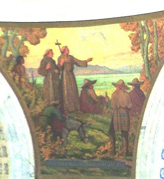
The Domínguez–Escalante Expedition was a Spanish journey of exploration conducted in 1776 by two Franciscan priests, Atanasio Domínguez and Silvestre Vélez de Escalante, to find an overland route from Santa Fe, New Mexico, to their Roman Catholic mission in Monterey, on the coast of modern day central California. Domínguez, Vélez de Escalante, and Bernardo de Miera y Pacheco, acting as the expedition's cartographer, traveled with ten men from Santa Fe through many unexplored portions of the American West, including present-day western Colorado, Utah, and northern Arizona. Along part of the journey, they were aided by three indigenous guides of the Timpanogos tribe.
The Santa Clara River is a 52-mile-long (84 km) river whose three forks join above Pine Valley in the Pine Valley Mountains in Washington County, Utah, United States. It flows west, then south, then briefly southeast before joining the Virgin River just south of downtown St. George. It is southern Utah's largest tributary to the Virgin River.
Rio Nutrias is a 35-mile-long (56 km) westward-flowing stream originating on the north slope of Canjilón Mountain in the Carson National Forest, in Rio Arriba County, New Mexico, United States. Rio Nutrias is tributary to the Rio Chama which it joins about 3-mile-long (4.8 km) below El Vado Reservoir in Rio Arriba County, in northern New Mexico.
Rio Nutria is a 32-mile-long (51 km) southwestward-flowing stream originating on McKenzie Ridge just west of the Continental Divide in the Cibola National Forest, in McKinley County, New Mexico, United States. Rio Nutria joins Rio Pescado to form the Zuni River in McKinley County on the Zuni Indian Reservation, in western New Mexico.
Crossing of the Fathers is a historical river crossing of the Colorado River, in Kane and San Juan Counties, Utah. The crossing, at an elevation of approximately 3,180 feet (970 m), was a series of sand bars at a great bend in the river located a mile west of Padres Butte, which is now at the tip of Padre Point on the south shore of Lake Powell. After the completion of Glen Canyon Dam in 1966, the crossing, along with the historical banks of the river itself, was submerged beneath nearly 400 feet (120 m) of water in Padre Bay on Lake Powell.
Padres Butte is a butte near the tip of Padre Point on the south shore of Lake Powell in San Juan County, Utah, United States.

Padre Point is a cape on the south shore of Lake Powell in extreme southwestern San Juan County, Utah, United States.

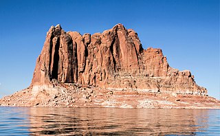
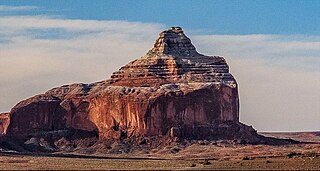
Dominguez Butte is a 4,476-foot elevation sandstone summit located south of Lake Powell, in San Juan County of southern Utah. It is situated on Navajo Nation land, 13 miles (21 km) northeast of the town of Page, and towers over 700 feet above the surrounding terrain as a landmark of the area. Dominguez Butte has a brief appearance in the 1968 film Planet of the Apes, when a spaceship crash lands in Lake Powell.
Boundary Butte is a 4,934-foot elevation sandstone summit located south of Lake Powell, in extreme southwestern San Juan County, Utah, United States, just north of the Arizona border. It is situated on Navajo Nation land, 11.5 miles (18.5 km) northeast of the town of Page, and towers 1,200 feet above the lake as a landmark of the area. It lies on the Utah-Arizona border, hence its name.

