Sources
Coordinates: 37°09′46″N110°55′25″W / 37.16278°N 110.92361°W
| | This article about a specific stratigraphic formation in Utah is a stub. You can help Wikipedia by expanding it. |
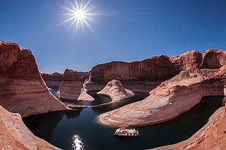
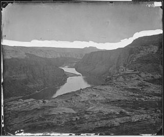
Music Temple was a geological feature near the Colorado River in Glen Canyon, southern Utah, United States, which consisted of a grotto with high, vaulting walls and a deep central pool of water.
It was discovered by John Wesley Powell in 1869, who named it "Music Temple" because of its unusual acoustic properties: reportedly, a one-second note would reverberate for eleven seconds. It was considered one of the more beautiful natural formations of the area in the late 19th century and into the mid-20th century.
After the construction of Glen Canyon Dam in the early 1960s, Music Temple was within the area that was submerged by Lake Powell. It disappeared by the mid-1960s as the lake filled. The site is located on the Navajo Nation.
Coordinates: 37°09′46″N110°55′25″W / 37.16278°N 110.92361°W
| | This article about a specific stratigraphic formation in Utah is a stub. You can help Wikipedia by expanding it. |

The Colorado River is one of the principal rivers in the Southwestern United States and northern Mexico. The 1,450-mile-long (2,330 km) river drains an expansive, arid watershed that encompasses parts of seven U.S. states and two Mexican states. Starting in the central Rocky Mountains of Colorado in Grand Lake, Colorado, the river flows generally southwest across the Colorado Plateau and through the Grand Canyon before reaching Lake Mead on the Arizona–Nevada border, where it turns south toward the international border. After entering Mexico, the Colorado approaches the mostly dry Colorado River Delta at the tip of the Gulf of California between Baja California and Sonora.

Glen Canyon Dam is a concrete arch-gravity dam on the Colorado River in northern Arizona, United States, near the town of Page. The 710-foot (220 m) high dam was built by the U.S. Bureau of Reclamation (USBR) from 1956 to 1966 and forms Lake Powell, one of the largest man-made reservoirs in the U.S. with a capacity of 27 million acre-feet (33 km3). The dam is named for Glen Canyon, a series of deep sandstone gorges now flooded by the reservoir; Lake Powell is named for John Wesley Powell, who in 1869 led the first expedition to traverse the Colorado River's Grand Canyon by boat.

Lake Powell is an artificial reservoir on the Colorado River in Utah and Arizona, United States. It is a major vacation spot visited by approximately two million people every year. It is the second largest artificial reservoir by maximum water capacity in the United States behind Lake Mead, storing 24,322,000 acre-feet (3.0001×10¹⁰ m3) of water when full. However, Lake Mead has fallen below Lake Powell in size several times during the 21st century in terms of volume of water, depth and surface area.

The Narrows is the narrowest section of Zion Canyon in Zion National Park, Utah, United States. Situated on the North Fork of the Virgin River and upstream of the main canyon, The Narrows is one of the premier hikes in the park and on the Colorado Plateau. The Narrows refers to both the 3.6-mile (5.8 km) bottom-up hike from the Temple of Sinawava to Big Springs, as well as the 16-mile (26 km) top-down hike from Chamberlain's Ranch back to the Temple of Sinawava.

Lees Ferry is a site on the Colorado River in Coconino County, Arizona in the United States, about 7.5 miles (12.1 km) southwest of Page and 9 miles (14 km) south of the Utah–Arizona state line.

The Colorado Plateau, also known as the Colorado Plateau Province, is a physiographic and desert region of the Intermontane Plateaus, roughly centered on the Four Corners region of the southwestern United States. This province covers an area of 336,700 km2 (130,000 mi2) within western Colorado, northwestern New Mexico, southern and eastern Utah, northern Arizona, and a tiny fraction in the extreme southeast of Nevada. About 90% of the area is drained by the Colorado River and its main tributaries: the Green, San Juan, and Little Colorado. Most of the remainder of the plateau is drained by the Rio Grande and its tributaries.

The Escalante River is a tributary of the Colorado River. It is formed by the confluence of Upper Valley and Birch Creeks near the town of Escalante in south-central Utah, and from there flows southeast for approximately 90 miles (140 km) before joining Lake Powell. Its watershed includes the high forested slopes of the Aquarius Plateau, the east slope of the Kaiparowits Plateau and the high desert north of Lake Powell. It was the last river of its size to be discovered in the 48 contiguous U.S. states. The average discharge is approximately 146 cfs.
Glen Canyon National Recreation Area is a national recreation area and conservation unit of the United States National Park Service that encompasses the area around Lake Powell and lower Cataract Canyon in Utah and Arizona, covering 1,254,429 acres (5,076.49 km2) of mostly rugged high desert terrain. The recreation area is named for Glen Canyon, which was flooded by the Glen Canyon Dam, completed in 1966, and is now mostly submerged beneath the waters of Lake Powell.
Glen Canyon is a natural canyon carved by a 169.6-mile (272.9 km) length of the Colorado River, mostly in southeastern and south-central Utah, in the United States. Glen Canyon starts where Narrow Canyon ends, at the confluence of the Colorado River and the Dirty Devil River. A small part of the lower end of Glen Canyon extends into northern Arizona and terminates at Lee's Ferry, near the Vermilion Cliffs. Like the Grand Canyon further downstream, Glen Canyon is part of the immense system of canyons carved by the Colorado River and its tributaries.
State Route 276 is a state highway in remote portions of San Juan County, eastern Garfield County, and Kane County, in the southeast of the U.S. state of Utah. The route is used as an access to Lake Powell, serving the small resort towns of Ticaboo and Bullfrog. SR-276 crosses Lake Powell via the Charles Hall Ferry, the only auto ferry in the state of Utah. The entire route is part of the Trail of the Ancients National Scenic Byway. Lake Powell separates the route into two sections; the eastern section was numbered State Route 263 prior to the existence of the ferry.

The Arizona Strip is the part of Arizona lying north of the Colorado River. Despite being larger in area than several U.S. states, the entire region has a population of fewer than 10,000 people. Consisting of northeastern Mohave County and northwestern Coconino County, the largest settlements in the Strip are Colorado City, Fredonia, and Beaver Dam, with smaller communities of Scenic, Littlefield and Desert Springs. The Kaibab Indian Reservation lies within the region. Lying along the North Rim of the Grand Canyon creates physical barriers to the rest of Arizona. Only three major roads traverse the region, I-15 crosses the northwestern corner while Arizona State Route 389 and U.S. Route 89A crosses the northeastern part of the strip, US 89A crosses the Colorado River via the Navajo Bridge, providing the only direct road connection between the strip and the rest of the state. The nearest metropolitan area is the St. George, Utah metro area, to which the region is more connected than to the rest of Arizona.

White Canyon is a canyon in San Juan County, Utah, United States.
The Kaiparowits Plateau is a large, elevated landform located in southern Utah, in the southwestern United States. Along with the Grand Staircase and the Canyons of the Escalante, it makes up a significant portion of the Grand Staircase-Escalante National Monument. Its extension to the southeast, Fiftymile Mountain, runs nearly to the Colorado River and Lake Powell, and is a prominent part of the northern skyline from the Glen Canyon National Recreation Area.

The San Juan Expedition was a group of Mormon settlers intent on establishing a colony in what is now southeastern Utah, in the western United States. Their difficult passage through the deep canyons of the Colorado River represents the ingenuity and determination needed during the country's era of western exploration and settlement.

The Canyons of the Escalante is a collective name for the erosional landforms created by the Escalante River and its tributaries—the Escalante River Basin. Located in southern Utah in the western United States, these sandstone features include high vertical canyon walls, numerous slot canyons, waterpockets, domes, hoodoos, natural arches and bridges. This area—extending over 1,500 square miles (3,885 km2) and rising in elevation from 3,600 ft (1,097 m) to over 11,000 ft (3,353 m)—is one of the three main sections of the Grand Staircase-Escalante National Monument, and also a part of the Glen Canyon National Recreation Area, with Capitol Reef National Park being adjacent to the east.
Fortymile Gulch and Willow Gulch are tributaries of the Escalante River, located in Kane County in southern Utah, in the western United States. With a combined length of over 20 miles (30 km), they exhibit many of the geologic features found in the Canyons of the Escalante, including high vertical canyon walls, water pools, narrow slot canyons, domes, and arches. Popular recreational destinations, they are located within the Grand Staircase-Escalante National Monument.

Bullfrog Basin is one of the National Park Service recreation sites of the Glen Canyon National Recreation Area of Kane County, Utah, United States, adjoining Lake Powell. It encompasses Bullfrog Basin Airport, the Bullfrog Resort and Marina, the Bullfrog terminus of the Charles Hall Ferry, and a campground.

Cataract Canyon is a 46-mile-long (74 km) canyon of the Colorado River located within Canyonlands National Park and Glen Canyon National Recreation Area in southern Utah. It begins at the Colorado's confluence with the Green River and its downstream terminus is the confluence with the Dirty Devil River. The lower half of the canyon is submerged beneath Lake Powell when the lake is at its normal high water elevation of 3,700 feet (1,100 m).

The Hite Crossing Bridge is an arch bridge that carries Utah State Route 95 across the Colorado River northwest of Blanding, Utah, United States. The bridge informally marks the upstream limit of Lake Powell and the end of Cataract Canyon of the Colorado River, but when the lake is at normal water elevation, the water can back up over 30 miles (48 km) upstream into Cataract Canyon. The bridge is the only automobile bridge spanning the Colorado River between the Glen Canyon Bridge, 185 miles (298 km) downstream near the Glen Canyon Dam and the U.S. Route 191 bridge 110 miles (180 km) upstream near Moab. The bridge is near Hite Marina on Lake Powell, and a small airstrip is immediately adjacent to the north side of the bridge.

Lone Rock is a solitary rock in Wahweap Bay in Lake Powell in Glen Canyon Recreation Area less than 10 miles (16 km) from Glen Canyon Dam. It is located within Kane County, Utah, United States.