Padres Butte

Last updated

Padres Butte
Padres Butte.jpg
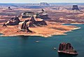
East aspect of Padres Butte, June 2015
Highest point
Elevation 4,043 ft (1,232 m)<= [1]
Prominence 463 ft (141 m) [1]
Parent peak Dominguez Butte [1]
Isolation 1.29 mi (2.08 km) [1]
Coordinates 37°02′54″N111°16′58″W / 37.0482943°N 111.2828789°W / 37.0482943; -111.2828789 [2]
Geography
USA Utah relief location map.svg
Red triangle with thick white border.svg
Padres Butte
Location in Utah
Usa edcp relief location map.png
Red triangle with thick white border.svg
Padres Butte
Padres Butte (the United States)
CountryUnited States
State Utah
County San Juan
Protected area Glen Canyon National Recreation Area
Parent range Colorado Plateau
Topo map USGS Gunsight Butte
Geology
Rock age Jurassic
Rock type Entrada Sandstone
Climbing
Easiest route class 5.x climbing [1]

Padres Butte is a butte near the tip of Padre Point on the south shore of Lake Powell in San Juan County, Utah, United States.

Contents

Description

The summit of the butte has an elevation of 4,043 feet (1,232 m). It was formerly an island in the man-made lake, but land connecting the butte with the rest of Padre Point has been exposed as the lake's water levels have declined. [3] [4]

Padres Butte marks the site of the historical Crossing of the Fathers, a series of sand bars along the great bend in the Colorado River a mile west of the butte that once offered a fordable crossing of the river. [5] This geographical feature's name was officially adopted in 1961 by the U.S. Board on Geographic Names. [2]

According to the Köppen climate classification system, Gregory Butte is located in an arid climate zone with hot, very dry summers, and chilly winters with very little snow. [6]

See also

References

  1. 1 2 3 4 5 "Padres Butte – 4,043' UT". listsofjohn.com. Retrieved November 11, 2020.
  2. 1 2 "Padres Butte". Geographic Names Information System . United States Geological Survey, United States Department of the Interior . Retrieved November 11, 2020.
  3. U.S. Geological Survey Geographic Names Information System: Padres Butte
  4. U.S. Geological Survey Geographic Names Information System: Padre Point
  5. U.S. Geological Survey Geographic Names Information System: Crossing of the Fathers (historical)
  6. Peel, M.C.; Finlayson, B.L. & McMahon, T.A. (2007). "Updated world map of the Köppen-Geiger climate classification" (PDF). Hydrology and Earth System Sciences . 11 (5): 1633–1644. Bibcode:2007HESS...11.1633P. doi: 10.5194/hess-11-1633-2007 . Archived (PDF) from the original on December 2, 2019. Retrieved November 7, 2025.