Algeria, since December 18, 2019, is divided into 58 wilayas (provinces). Prior to December 18, 2019, there were 48 provinces. The 58 provinces are divided into 1,541 baladiyahs (municipalities). The name of a province is always that of its capital city.

Aïn Defla (Arabic: ولاية عين الدفلى, is a wilaya in northern Algeria. It is located to the southwest of Algiers, the capital. Localities in Ain Delfa include Aïn Defla, Miliana, El Attaf, Djelida and Djendel.

The Chenouis or Chenoua are a Berber ethnic group native to the Chenoua Mountains in northern Algeria. They traditionally inhabit areas between the east of Ténès to the west of Cherchell. The Chenoui people number about 106,000. They speak the Shenwa language, a Northern Berber language that is closely related to the Shawiya language and Zenata varieties spoken by Berbers of the Aures mountains in Eastern Algeria and the Rif region. The Shenwa language has about 76,000 speakers.

Rouïba or Rouiba is a municipality of Algeria. It is located 22 kilometres (14 mi) in the eastern suburbs of Algiers in one of the most healthy localities of Algeria. It is also the district seat of Rouïba District in Algiers Province. Its inhabitants are called Rouibéens.

Baraki is a district in Algiers Province, Algeria. It was named after its capital, Baraki. Baraki is located in the suburbs southeast of Algiers, and the capital of the Baraki district is situated about 14km southeast of Algiers and 35km northeast of Blida.
Dar El Beïda is a district in Algiers Province, Algeria. It was named after its capital, Dar El Beïda.
Chéraga is a district in Algiers Province, Algeria. It was named after its capital, Chéraga.
For the commune of Algiers, see Aïn Benian, Algiers
Bouchared is one of the municipalities of the Algerian state of Ain Defla, about 150 km away from Algiers. Its area is estimated at 138 km2 and its population is estimated at 35 thousand people, according to the latest statistics for the year 2012.
Boumedfaa a town in northern Algeria.

Djendel is a commune in the Aïn Defla wilaya in northern Algeria, located 110 km southwest of Algiers, 40 km east of Aïn Defla, and 30 km southwest of Médéa.

El Amra is a town in northern Algeria.

Aïn Benian is a commune in Algiers Province and suburb of the city of Algiers in northern Algeria. As of the 2008 census, the commune had a population of 68,354.
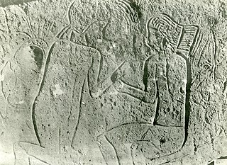
The rock art of the Djelfa region in the Ouled Naïl Range (Algeria) consists of prehistoric cave paintings and petroglyphs dating from the Neolithic age which have been recognized since 1914. Following the Saharan Atlas Mountains they follow on from those, to the west, of south Oran, to which they are related. Comparable engravings have also been described further to the east, in the Constantine (Algeria) region.

Aïn Oussera or Aïn Oussara is a city in Djelfa Province, Algeria, with an estimated (2005) population of 134,174. It is the district seat of the Aïn Oussera District. This city, located 200 km south of the capital Algiers, is crossed by the Trans-Saharan Highway main road number 1. The road that runs through the whole of Algeria from north to south over 2000 km, connects Algiers on its southern border with Mali near Tamanrasset. Ain Oussera, has experienced, since 1990, rapid population growth due to its proximity to the 15 MW Es Salam nuclear reactor. Aïn Oussera is on the crossroads of the N1 (Trans-Saharan) and N40B highways. The nearest airport is the Algerian Air Force's Aïn Oussera airfield (DAAQ).

Djendel District is a district of Aïn Defla Province, Algeria.
Ain Laloui is a town and commune in Bouïra Province, Algeria. According to the 1998 census, it has a population of 5,893.
Empire Commerce was a 3,722 GRT tanker that was built in 1942 by Sir J Laing & Sons Ltd, Sunderland for the Ministry of War Transport(MoWT). She entered service in March 1943 and was torpedoed on 1 October 1943 and sunk by U-410.

Aïn Arnat is a town and commune in Sétif Province in north-eastern Algeria.

Aïn Oulmene, the classical Zaraï, is a town and commune in Sétif Province in north-eastern Algeria.