Bouchared

Last updated
Bourached
Country Algeria
Province Aïn Defla
Time zone UTC+1 (West Africa Time)

Bouchared is one of the municipalities of the Algerian state of Ain Defla, about 150 km away from Algiers. Its area is estimated at 138 km2 and its population is estimated at 35 thousand people, according to the latest statistics for the year 2012. [1]

Contents

Location

It is located southwest of the city of Ain Defla, where its municipal headquarters is about 13 km away from Ain Defla. It is bordered to the north by Ain Defla, to the south by the municipalities of Jomaa Ouled Sheikh and Zedine, to the east by the municipality of Jlida, and to the west by the municipality of Rouina. It is distinguished by its excellent strategic location, as it is located between the hills, on the plateaus and on the outskirts of the Douai Mountains and its small forest with a charming nature and stunning views that lie between it and the city of Ain Defla. It overlooks from the other side the Al-Wancheris mountain range and its dense forests, and on its western border is the Ouled Maluk Dam, and this is what makes it so distinctive. An important location, a dry climate, and a pleasant atmosphere, if you have not yet discovered it.

Municipality development

The municipality of Bourached has experienced significant growth in various sectors, particularly after the construction of the east-west highway, which facilitated its urban development. This expansion has created a conducive environment for launching major projects, one notable example being the wholesale market project. Initiated by the Minister of Commerce, Mustafa Ben Badda, at the end of 2012, this project is anticipated to meet international standards upon completion. It is designed to include comprehensive facilities, such as hotel services, a bank, and a security center.

In the educational sector, Bourached is home to several institutions. It boasts a secondary school named "Bouchareb Al-Taher" and two middle schools, "Mkhaledi Kouider" and "Galloaz Moussa", the latter being recognized as the oldest educational structure in the area, having been established in 1987. A new middle school was recently constructed on the former site of the Bouchareb Al-Tahir Secondary School, which has since been relocated to a new building opposite the old one for the 2014/2015 school year. This new facility was inaugurated by the Minister of Education, Nouria Ben Ghabrit. Additionally, the "Ahmed Rashidi" Middle School, dedicated to the children of Si Ahmed, was opened in 2001 by the Minister of National Education, Abu Bakr Ben Bouzid. Bourached also hosts approximately 14 primary schools, with Bahi Al-Hajj being the oldest, established in 1972 in the children of Si Ahmed area.

Related Research Articles

Articles related to Algeria include:

<span class="mw-page-title-main">Provinces of Algeria</span> Administrative divisions of the country in North Africa

Algeria, since December 18, 2019, is divided into 58 wilayas (provinces). Prior to December 18, 2019, there were 48 provinces. The 58 provinces are divided into 1,541 baladiyahs (municipalities). The name of a province is always that of its capital city.

<span class="mw-page-title-main">Boumerdès Province</span> Province of Algeria

Boumerdès is a province (wilaya) of northern Algeria, located in the Kabylia region, between Algiers and Tizi-Ouzou, with its capital at the coastal city of Boumerdès just east of Algiers.

<span class="mw-page-title-main">Batna Province</span> Province of Algeria

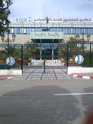
Batna Province is a province of Algeria, in the region of Aurès. The capital is Batna. Localities in this province include N'Gaous, Merouana and Timgad. Belezma National Park is in the Belezma Range area of the province.

<span class="mw-page-title-main">Sétif Province</span> Province of Algeria

Sétif Province is a province (wilaya) in north-eastern Algeria. Its capital and largest city is Sétif; the next largest city is El Eulma. There is also the World Heritage Site of Djémila there.

<span class="mw-page-title-main">Aïn Defla Province</span> Province of Algeria

Aïn Defla (Arabic: ولاية عين الدفلى, is a wilaya in northern Algeria. It is located to the southwest of Algiers, the capital. Localities in Ain Delfa include Aïn Defla, Miliana, El Attaf, Djelida and Djendel.

<span class="mw-page-title-main">Laghouat Province</span> Province of Algeria

Laghouat is one of the fifty-eight provinces (wilaya) of Algeria. It is located in the north central part of Algeria. The province borders Tiaret Province to the north, El Bayadh Province to the west, Ghardaia Province to the south and Djelfa Province to the east. The capital of the province is Laghouat City. The province is famous for palm trees and livestock.

<span class="mw-page-title-main">Bordj Bou Arréridj Province</span> Province of Algeria

Bordj Bou ArréridjProvince is a province (wilaya) in northern Algeria around 200 km from the capital Algiers. It is considered as a crossroads between the east and west, the north and south.

<span class="mw-page-title-main">Guelma Province</span> Province of Algeria

Guelma Province is a province (wilaya) in eastern Algeria. Its namesake is its seat and most populous municipality: Guelma.

<span class="mw-page-title-main">Chlef Province</span> Province of Algeria

Chlef is a province (wilaya) in Algeria. Its capital and biggest city is Chlef. It is the 8th most populous province in the country, having just over 1 million inhabitants.

<span class="mw-page-title-main">Miliana</span> Commune and town in Aïn Defla, Algeria

Miliana is a commune in Aïn Defla Province in northwestern Algeria. It is the administrative center of the daïra, or district, of the same name. It is approximately 114 kilometres (71 mi) southwest of the Algerian capital, Algiers. The population was estimated at 44,201 in 2008. The town is located south of the Dahra Range, on the wooded southern flank of Mount Zaccar Rherbi, five kilometers north of the Chelif River, and overlooking the Zaccar plateau to the west.

<span class="mw-page-title-main">M'Sila Province</span> Province of Algeria

M'Sila is a province (wilaya) of northern Algeria. It has a population of 1 million people and an area of 18,718 km², while its capital, also called M'Sila, home to M'Sila University, has a population of about 100,000.

<span class="mw-page-title-main">Thénia District</span> District in Boumerdès, Algeria

Thénia is a district in Boumerdès Province, Algeria. It was named after its capital, Thénia which, under French rule, was called Ménerville.

<span class="mw-page-title-main">El Amra</span> Place in Aïn Defla, Algeria

El Amra is a town in northern Algeria.

<span class="mw-page-title-main">Rock art of the Djelfa region</span>

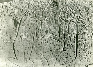
The rock art of the Djelfa region in the Ouled Naïl Range (Algeria) consists of prehistoric cave paintings and petroglyphs dating from the Neolithic age which have been recognized since 1914. Following the Saharan Atlas Mountains they follow on from those, to the west, of south Oran, to which they are related. Comparable engravings have also been described further to the east, in the Constantine (Algeria) region.

<span class="mw-page-title-main">Ras El Aioun District</span> District in Batna Province, Algeria

Ras El Aioun is a district of Batna Province, Algeria. In 2008, the district's population was estimated to be around 130,000. Ras El Aioun is located on the Mediterranean Sea and in the north-central portion of Algeria.

<span class="mw-page-title-main">Zemmouri</span> Commune and town in Boumerdès Province, Algeria

Zemmouri is a town and commune in the Bordj Menaïel District of Boumerdès Province, Algeria. As of 2008, the population of the municipality is 26,408.

<span class="mw-page-title-main">Aït Yahia</span> Commune in Kabylie, Algeria

Aït Yahia is a commune in the Tizi Ouzou wilaya in northern Algeria, located 47 km to the southwest of Tizi Ouzou, 33 km to the south of Azazga, and 4 km northeast of Aïn El Hammam. The administrative center of the commune is the village of Ait Hichem [fr].

<span class="mw-page-title-main">Bounouh</span> Commune and town in Tizi Ouzou, Algeria

Bou-Nouh is a town and commune in Tizi Ouzou Province in northern Algeria.

References

  1. "Relation: Bourached (2762966)". OpenStreetMap. 2020-11-19. Retrieved 2024-04-11.

36°10′09″N1°55′45″E / 36.1691°N 1.9292°E / 36.1691; 1.9292