Hochheim, Thuringia

Last updated
Hochheim
Location of Hochheim
Hochheim, Thuringia
Germany adm location map.svg
Red pog.svg
Hochheim
Thuringia location map.svg
Red pog.svg
Hochheim
Coordinates: 51°1′1″N10°39′33″E / 51.01694°N 10.65917°E / 51.01694; 10.65917
Country Germany
State Thuringia
District Gotha
Municipality Nessetal
Area
  Total7.68 km2 (2.97 sq mi)
Elevation
277 m (909 ft)
Population
 (2017-12-31)
  Total446
  Density58/km2 (150/sq mi)
Time zone UTC+01:00 (CET)
  Summer (DST) UTC+02:00 (CEST)
Postal codes
99869
Dialling codes 036255
Vehicle registration GTH

Hochheim is a village and Ortschaft of the municipality Nessetal in the district of Gotha, in Thuringia, Germany. [1] Before 1 January 2019, when it was merged into the new municipality Nessetal, it was an independent municipality. [2]

Contents

It is the probable birthplace of the famous theologian Meister Eckhart.

Geography

Hochheim is located in fertile Nesse valley in the northern part of the Gotha Land, in the triangle formed by the cities and towns of Gotha, Bad Langensalza and Erfurt. The settlement is close to the B247 federal highway on the southern foothills of the Hainich and lies at around 269 to 290 metres above sea level (NN). The neighbouring towns are Goldbach to the south, Westhausen to the east, Wangenheim to the west and Wiegleben to the north.

To the north of the town, meadows and fields run up to the woodland of the Wiegleber Holz and one of the largest wind farms in Thuringia. The northern Hochheimer Flur is also part of the watershed of the rivers Elbe and Weser. In the damp lowlands on the southern edge of the town, the Nesse (the largest tributary of the Hörsel) flows westwards. Here, in the 15th century, monks built an artificial mill race alongside the knight's mill (Rittermühle). On the western border of Wangenheim lies the Tiefenbornsteich pond ( 51°00′54″N10°38′30″E / 51.0151°N 10.6417°E / 51.0151; 10.6417 (Tiefenbornsteich) ) and a larger area of marsh, which is historically significant.

History

Early History

Hochheim, sometimes also called “Loh-Hochheim”, [3] was first mentioned in a donation deed to the Diocese of Fulda in 778.

Near the Tiefenbornsteich, the remains of the a settlement of the Linear Pottery Culture were uncovered in several places during exploratory excavations in the Hochheimer Flur and the nearby Seefeldsiedlung near Wangenheim. Archaeologists also made the oldest gold find in Thuringia here. A Roman settlement at Tiefenbornsteich has also been archaeologically uncovered.

After the acquisition of the Diocese of Fulda by the lords of Wangenheim, Hochheim belonged to the Wangenheim jurisdiction in the Duchy of Saxe-Gotha-Altenburg or Duchy of Saxe-Coburg-Gotha until the abolition of the patrimonial courts in the mid-19th century. The lords of Wangenheim and von Uechtritz had properties in the town.

Hochheim also had a larger castle and two manorial estates (Rittergüte), one of which has survived. Only the foundations of the former castle remain, which are covered by new buildings. Documentary records report that as early as the 16th century, grain ships of the Diocese of Fulda sailed up to the upper reaches of the Nesse near Wangenheim and Haina to collect the grain tributes from upland settlements such as Hochheim.

Recent history

Hochheim was handed over to US troops in April 1945 without any major combat operations. After the Soviet occupiers took over, the war memorial was moved to what is now the cemetery area to protect it from demolition. After the end of the Second World War, numerous refugees from the German eastern regions of Silesia, Pomerania, the Sudetenland and East Prussia came to Hochheim. The LPG "Freier Bauer" ("Free Farmers") and later the KAP Nessetal were founded on the old estates (Gutshöfen).

After the political change and the German reunification, the Goldbach agricultural cooperative took over the agricultural land and livestock. The structure of the village has been managed through the astute budgetary policy of the active mayors. For this purpose, the place was equipped with a modern sewerage system and all streets were renovated without the villagers having to pay for it. The community is now debt-free.

In 2015, St. Nicholas Church was re-inaugurated after a two-year renovation. Likewise, the former kindergarten was converted into a town hall, the school kitchen, fire station and sports field were renovated and a playground built.

On 1 January 2019, the formerly independent communities of Hochheim, Ballstädt, Bufleben, Friedrichswerth, Goldbach, Haina, Brüheim, Remstädt, Wangenheim, Warza and Westhausen merged to form the rural community of Nessetal (Nesse Valley). Hochheim was a member of the Verwaltungsgemeinschaft Mittleres Nessetal. [4]

Population growth

Growth of population (31 December):

  • 1994 – 544
  • 1995 – 545
  • 1996 – 567
  • 1997 – 567
  • 1998 – 566
  • 1999 – 562
  • 2000 – 557
  • 2001 – 548
  • 2002 – 546
  • 2003 – 538
  • 2004 – 516
  • 2005 – 508
  • 2006 – 503
  • 2007 – 488
  • 2008 – 474
  • 2009 – 480
  • 2010 – 461
  • 2011 – 476
  • 2012 – 478
  • 2013 – 463
  • 2014 – 458
  • 2015 – 456
  • 2016 – 437
  • 2017 – 446

Related Research Articles

<span class="mw-page-title-main">Thuringia</span> State in Germany

Thuringia, officially the Free State of Thuringia, is a state of central Germany, covering 16,171 square kilometres (6,244 sq mi), the sixth smallest of the sixteen German states. It has a population of about 2.1 million.

<span class="mw-page-title-main">Alfred, Duke of Saxe-Coburg and Gotha</span> British prince and German duke (1844–1900)

Alfred was sovereign Duke of Saxe-Coburg and Gotha from 1893 to 1900. He was the second son and fourth child of Queen Victoria and Prince Albert. He was known as the Duke of Edinburgh from 1866 until he succeeded his paternal uncle Ernest II as the reigning Duke of Saxe-Coburg and Gotha in the German Empire.

Gotha is a Kreis (district) in western central Thuringia, Germany. Neighboring districts are Unstrut-Hainich-Kreis, Sömmerda, the Kreis-free city Erfurt, Ilm-Kreis, Schmalkalden-Meiningen and the Wartburgkreis.

<span class="mw-page-title-main">Saxe-Weimar-Eisenach</span> Historical German state from 1809 to 1920

Saxe-Weimar-Eisenach was a German state, created as a duchy in 1809 by the merger of the Ernestine duchies of Saxe-Weimar and Saxe-Eisenach, which had been in personal union since 1741. It was raised to a grand duchy in 1815 by resolution of the Congress of Vienna. In 1903, it officially changed its name to the Grand Duchy of Saxony, but this name was rarely used. The grand duchy came to an end in the German Revolution of 1918–19 with the other monarchies of the German Empire. It was succeeded by the Free State of Saxe-Weimar-Eisenach, which was merged into the new Free State of Thuringia two years later.

<span class="mw-page-title-main">Gotha</span> Town in Thuringia, Germany

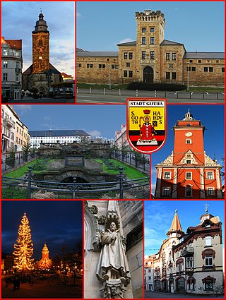
Gotha is the fifth-largest city in Thuringia, Germany, 20 kilometres west of Erfurt and 25 km east of Eisenach with a population of 44,000. The city is the capital of the district of Gotha and was also a residence of the Ernestine Wettins from 1640 until the end of monarchy in Germany in 1918. The House of Saxe-Coburg and Gotha originating here spawned many European rulers, including the royal houses of the United Kingdom, Belgium, Portugal and Bulgaria.

<span class="mw-page-title-main">Saalfeld</span> Town in Thuringia, Germany

Saalfeld is a town in Germany, capital of the Saalfeld-Rudolstadt district of Thuringia. It is best known internationally as the ancestral seat of the Saxe-Coburg and Gotha branch of the Saxon House of Wettin.

<span class="mw-page-title-main">Meiningen</span> Town in Thuringia, Germany

Meiningen is a town in the southern part of the state of Thuringia, Germany. It is located in the region of Franconia and has a population of around 25,000 (2021). Meiningen is the capital and the largest town of the Schmalkalden-Meiningen district. From 1680 to 1920, Meiningen was the capital of the Duchy of Saxe-Meiningen.

<span class="mw-page-title-main">Coburg</span> Town in Bavaria, Germany

Coburg is a town located on the Itz river in the Upper Franconia region of Bavaria, Germany. Long part of one of the Thuringian states of the Wettin line, it joined Bavaria by popular vote only in 1920. Until the revolution of 1918, it was one of the capitals of the Duchy of Saxe-Coburg and Gotha and the Duchy of Saxe-Coburg-Saalfeld.

<span class="mw-page-title-main">Gräfenroda</span> Ortsteil of Geratal in Thuringia, Germany

Gräfenroda is a village and a former municipality in the Ilm-Kreis district, in Thuringia, Germany. Since 1 January 2019, it has been part of the municipality of Geratal. It was the administrative seat of the former Verwaltungsgemeinschaft Oberes Geratal.

<span class="mw-page-title-main">Margravate of Meissen</span> Medieval margravate (965–1423)

The Margravate or Margraviate of Meissen was a medieval principality in the area of the modern German state of Saxony. It originally was a frontier march of the Holy Roman Empire, created out of the vast Marca Geronis in 965. Under the rule of the Wettin dynasty, the margravate finally merged with the former Duchy of Saxe-Wittenberg into the Saxon Electorate by 1423.

<span class="mw-page-title-main">Creuzburg</span> Ortsteil of Amt Creuzburg in Thuringia, Germany

Creuzburg is a town and a former municipality on the Werra river in the Wartburgkreis in Thuringia, Germany. Since December 2019, it is part of the town Amt Creuzburg.

<span class="mw-page-title-main">Geisa</span> Town in Thuringia, Germany

Geisa is a town in the Wartburgkreis district, in Thuringia, Germany. It is situated in the Rhön Mountains, 26 km northeast of Fulda. The near border with Hesse was the border between West Germany and the GDR during the Cold War. Thus, Geisa was in the East German border restriction area of the former inner German border, which meant that until reunification access to the town was limited. The town is the westernmost municipality in what was formerly East Germany.

<span class="mw-page-title-main">House of Henneberg</span> Noble family

The House of Henneberg was a medieval German comital family (Grafen) which from the 11th century onwards held large territories in the Duchy of Franconia. Their county was raised to a princely county in 1310.

Mittleres Nessetal is a former Verwaltungsgemeinschaft in the district of Gotha, in Thuringia, Germany. The seat of the Verwaltungsgemeinschaft was in Goldbach. It was disbanded in January 2019, when 11 of its 12 municipalities were merged into the new municipality Nessetal.

<span class="mw-page-title-main">Nesse (Hörsel)</span> River in Thuringia, Germany

The Nesse is a 54.5-kilometre-long (33.9 mi) tributary of the Hörsel in the southern Thuringia. Strictly speaking, it represents a second, right main branch of the Hörsel, which brings about as much water to join the Hörsel as the Hörsel itself and drains an even larger catchment area.

<span class="mw-page-title-main">Veste Coburg</span> Medieval fortress in the town of Coburg, Germany

The Veste Coburg is one of the best-preserved medieval fortresses of Germany. It is situated on a hill above the town of Coburg, in the Upper Franconia region of Bavaria.

<span class="mw-page-title-main">Heldburger Land</span>

The Heldburger Land was the historical, Saxon, administrative district (Amtsbezirk) of Heldburg and is today the southernmost part of the Free State of Thuringia and the district of Hildburghausen, between the towns of Coburg, Hildburghausen and Bad Königshofen. The region known now as the Heldburger Land is referred to administratively as the Heldburger Unterland, and sometimes in the vernacular as the Heldburger Zipfel.

<span class="mw-page-title-main">Friedenstein Palace</span> Palace in Gotha, Germany

Friedenstein Palace is an early Baroque palace built in the mid-17th century by Ernest I, Duke of Saxe-Gotha at Gotha, Thuringia, Germany. In Germany, Friedenstein was one of the largest palaces of its time and one of the first Baroque palaces ever built. Friedenstein served as the main seat of the Dukes of Saxe-Gotha and later as one of the residences of the Dukes of Saxe-Coburg and Gotha, closely linked with the royal family of Great Britain through the marriage of Queen Victoria and Prince Albert. The final two ruling Dukes were both princes of the United Kingdom.

<span class="mw-page-title-main">Nessetal</span> Municipality in Thuringia, Germany

Nessetal is a municipality in the district of Gotha, in Thuringia, Germany. It was created with effect from 1 January 2019 by the merger of the former municipalities of Ballstädt, Brüheim, Bufleben, Friedrichswerth, Goldbach, Haina, Hochheim, Remstädt, Wangenheim, Warza and Westhausen. These former municipalities are now Ortschaften of the municipality Nessetal. The name refers to the river Nesse.

<span class="mw-page-title-main">Aschara</span> Ortsteil of Bad Langensalza in Thuringia, Germany

Aschara is a village and part of the town of Bad Langensalza in Thuringia, central Germany, with 440 inhabitants.

References

  1. Hauptsatzung, Gemeinde Nessetal, December 2022.
  2. Gebietsänderungen von Januar bis Dezember 2019, Statistisches Bundesamt
  3. Archived (Date missing) at eckhart.de (Error: unknown archive URL)
  4. Thuringian Law and Ordinance Gazette No. 14/2018. on May 20, 2019