
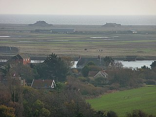
RSPB Leighton Moss is a nature reserve in Lancashire, England, which has been in the care of the Royal Society for the Protection of Birds since 1964. It is situated near Silverdale, Carnforth, on the edge of Morecambe Bay and in the Arnside and Silverdale Area of Outstanding Natural Beauty.

Millom is a town and civil parish on the north shore of the estuary of the River Duddon in southernmost Cumberland, Cumbria, England. It is situated just outside the Lake District National Park, about six miles north of Barrow-in-Furness and 26 mi (42 km) south of Whitehaven.

The River Esk, sometimes called the Cumbrian Esk, is a river in Cumbria, England. It flows for approximately 25 km from its source in the Scafells range of mountains to its estuary at Ravenglass. The valley it flows through is known as Eskdale. It is one of two Rivers Esk in Cumbria, and not to be confused with the Border Esk which flows into Cumbria from Scotland.
Orford Ness is a cuspate foreland shingle spit on the Suffolk coast in Great Britain, linked to the mainland at Aldeburgh and stretching along the coast to Orford and down to North Weir Point, opposite Shingle Street. It is divided from the mainland by the River Alde, and was formed by longshore drift along the coast. The material of the spit comes from places further north, such as Dunwich. Near the middle point of its length, at the foreland point or 'Ness', once stood Orfordness Lighthouse, demolished in summer 2020 owing to the encroaching sea. In the name of the lighthouse, 'Orfordness' is written as one word.

The Duddon Estuary is the sandy, gritty estuary of the River Duddon that lies between Morecambe Bay and the North Lonsdale coast.
Haverigg is a village on the south-west coast of Cumbria, England, historically part of the county of Cumberland. In 2001 it had a population of 1,791 in 548 households, increasing in 2011 to a population of 1,849 in 549 Households.

Cemlyn Bay is a bay on the northwest coast of Anglesey, North Wales, approximately 2.5 km west of Wylfa nuclear power station, within the community of Cylch-y-Garn.

The Ythan Estuary is the tidal component of the Ythan River, emptying into the North Sea 19 kilometres (12 mi) north of Aberdeen, Scotland. The estuary’s tidal action extends a 7 kilometres (4.3 mi) inland and has characteristic widths of between 250 metres (820 ft) and 780 metres (2,560 ft). Besides the tidal channel there are interfaces to the upland dunes including mudflats, sand beaches and shingle flats. Reaches of salt marsh occur, but they are primarily near the Waterside Bridge and the mouth of the Tarty Burn, a small tributary river. Based upon the habitat of the moorland bordering the east of the Ythan River near the mouth, this estuary is the most significant coastal moorland in the northern United Kingdom.
Millom Heritage and Arts Centre, formerly known as the Millom Folk Museum and Millom Discovery Centre, is located in Millom, Cumbria, England. The museum has a full-scale drift mine exhibit and also houses information about the local poet Norman Nicholson, the Hodbarrow iron ore mines and social history all relating to Millom and nearby surrounding areas. The mining being responsible for the rapid growth of the village of Holborn Hill into the town of Millom by more than doubling the size of the settlement. It now has a RAF display, set up by the original founder of Haverigg RAF Museum, John Nixon. It also shows the men who died in World War 2 and has information about them
Arnside and Silverdale National Landscape in England, is on the border between Lancashire and Cumbria, adjoining Morecambe Bay. One of the smallest National Landscapes, it covers 29 square miles (75 km2) between the Kent Estuary, the River Keer and the A6 road. It was designated in 1972.

Havergate Island is the only island in the county of Suffolk, England. It is found at the confluence of the River Ore and the Butley River near the village of Orford. It is a marshy nature reserve run by the Royal Society for the Protection of Birds (RSPB) and is known for its population of pied avocets and terns. It is part of the ecologically important Alde-Ore Estuary and has protected conservation status as part of a national nature reserve, SSSI, SAC, SPA, Ramsar Site and is also a part of the Suffolk Coast and Heaths AONB.

Askam and Ireleth is a civil parish close to Barrow-in-Furness in Westmorland and Furness, Cumbria, England. Historically part of Lancashire, it originally consisted of two separate coastal villages with different origins and histories which, in recent times, have merged to become one continuous settlement. In the 2001 census the parish had a population of 3,632, reducing at the 2011 census to 3,462.

Rye Meads is a 58.5-hectare (145-acre) biological Site of Special Scientific Interest (SSSI) in Rye House, Hoddesdon, Hertfordshire. It is one of series of wetlands and reservoirs situated along the River Lea, to the north-east of London. It is part of the Lea Valley Ramsar site and a Special Protection Area.

North Walney Nature Reserve is a national nature reserve on Walney Island, England. The reserve, which has an area of 646.5 ha, is notable as a habitat of natterjack toads. It is one of the sites in the Duddon Estuary which support one-fifth of the national population of the rare amphibian.

South Walney is one of two nature reserves on Walney Island, England. The nature reserve has an area of 130 ha leased from Holker estates. It has been managed by the Cumbria Wildlife Trust since 1963. The reserve is notable for being a colony for gulls and grey seals.

Sandscale Haws is a national nature reserve on the Duddon Estuary, Cumbria, England. It is managed by the National Trust. Resident species include the natterjack toad.

Roanhead refers to the limestone outcrop of Roanhead Crag in Cumbria and the farmland behind it, but in recent years the term has been taken to mean the sandy beaches adjoining Sandscale Haws extending to Snab Point. The Irish Sea lies to the west of Roanhead, whilst the Duddon Estuary and Walney Channel are due north and south respectively. The beach is noted for its abundance of sand dunes and strong, often dangerous coastal currents. Today the beach is a National Trust conservation area, and a two-mile stretch of the Cumbria Coastal Way runs through it.

Hurst Castle and Lymington River Estuary is a 1,077.3-hectare (2,662-acre) biological and geological Site of Special Scientific Interest near Lymington in Hampshire. It is a Nature Conservation Review site and two areas are Geological Conservation Review sites. Three areas are local nature reserves, Boldre Foreshore, Sturt Pond and Lymington and Keyhaven Marshes; the latter site is managed by the Hampshire and Isle of Wight Wildlife Trust. Part of it is North Solent National Nature Reserve. It is part of Solent and Southampton Water Ramsar site and Special Protection Area. Parts of it are in Solent Maritime and Solent and Isle of Wight Lagoons Special Areas of Conservation.

