Holes Bay Nature Park | |
---|---|
Shoreline of Holes Bay | |
Nearest city | Poole |
Coordinates | 50°44′13″N2°00′41″W / 50.7369°N 2.0113°W Coordinates: 50°44′13″N2°00′41″W / 50.7369°N 2.0113°W |
Area | 286 ha (710 acres) |
Established | March 2015 |
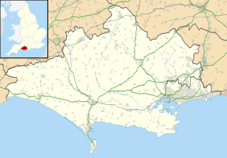
Holes Bay Nature Park is a protected area, 286 hectares in size, on and around Holes Bay, an embayment of Poole Harbour within the Borough of Poole that is important for wildlife, especially wetland birds. It was designated a nature park in March 2015. [1] [2]
Protected areas or conservation areas are locations which receive protection because of their recognized natural, ecological or cultural values. There are several kinds of protected areas, which vary by level of protection depending on the enabling laws of each country or the regulations of the international organizations involved.
Holes Bay is an intertidal embayment off Poole Harbour in the county of Dorset on the south coast of England. It lies mostly within the Borough of Poole and is close to Poole town centre. It is an important wetland bird haven.
Poole Harbour is a large natural harbour in Dorset, southern England, with the town of Poole on its shores. The harbour is a drowned valley (ria) formed at the end of the last ice age and is the estuary of several rivers, the largest being the Frome. The harbour has a long history of human settlement stretching to pre-Roman times. The harbour is extremely shallow, with one main dredged channel through the harbour, from the mouth to Holes Bay.
The nature park is intended to bring landowners, local communities and local businesses closer to nature and ensure the habitat is managed for the benefit of the great variety of wildlife found within it. [3]
The nature park is "one of the best places to see the wildlife of Poole Harbour" [2] and "a fabulous wildlife area at the commercial heart of Poole." [3] Its salt marshes and mudflats attract a wide variety of wetland birds. The bay is divided into northern and southern areas by the South Western Main Line from London to Weymouth which crosses it on an embankment. The northern area is particularly sensitive due to the number of birds that use it to feed and roost. [2]
London is the capital and largest city of both England and the United Kingdom. Standing on the River Thames in the south-east of England, at the head of its 50-mile (80 km) estuary leading to the North Sea, London has been a major settlement for two millennia. Londinium was founded by the Romans. The City of London, London's ancient core − an area of just 1.12 square miles (2.9 km2) and colloquially known as the Square Mile − retains boundaries that follow closely its medieval limits. The City of Westminster is also an Inner London borough holding city status. Greater London is governed by the Mayor of London and the London Assembly.
Weymouth is a seaside town in Dorset, England, situated on a sheltered bay at the mouth of the River Wey on the English Channel coast. The town is 11 kilometres (7 mi) south of Dorchester and 8 kilometres (5 mi) north of the Isle of Portland. The town's population is 52,323 (2011). Weymouth has a metropolitan population of 71,083 (2016). The town is the third largest settlement in Dorset after the unitary authorities of Bournemouth and Poole.
The nature park includes Upton Country Park, with Upton House and Pergins Island, as well as trails that run around the bay. These include the Castleman Trailway, Walk No. 6 of the Poole Harbour Trails and the Poole Heritage Cycle Route. South of the marina in the southwest corner of the bay is the Hamworthy Creeks Nature Reserve. [2]
Upton House is a country house in the grounds of Upton Country Park on the northwestern shoreline of Holes Bay in the county of Dorset on the south coast of England. It is owned by the Borough of Poole.
Pergins Island is a small, uninhabited island in Holes Bay, an embayment off Poole Harbour in Dorset on the south coast of England. It is not accessible to the public.
The Castleman Trailway is a footpath in Southern England. Portions of the trailway are also a cyclepath but the middle section from East Wimborne to the River Allen bridge is not cyclable.
Salt marsh, intertidal mudflats, parkland and heathland. [2]
A salt marsh or saltmarsh, also known as a coastal salt marsh or a tidal marsh, is a coastal ecosystem in the upper coastal intertidal zone between land and open saltwater or brackish water that is regularly flooded by the tides. It is dominated by dense stands of salt-tolerant plants such as herbs, grasses, or low shrubs. These plants are terrestrial in origin and are essential to the stability of the salt marsh in trapping and binding sediments. Salt marshes play a large role in the aquatic food web and the delivery of nutrients to coastal waters. They also support terrestrial animals and provide coastal protection.
Mudflats or mud flats, also known as tidal flats, are coastal wetlands that form when mud is deposited by tides or rivers. They are found in sheltered areas such as bays, bayous, lagoons, and estuaries. Mudflats may be viewed geologically as exposed layers of bay mud, resulting from deposition of estuarine silts, clays and marine animal detritus. Most of the sediment within a mudflat is within the intertidal zone, and thus the flat is submerged and exposed approximately twice daily.
A park is an area of natural, semi-natural or planted space set aside for human enjoyment and recreation or for the protection of wildlife or natural habitats. Urban parks are green spaces set aside for recreation inside towns and cities. National parks and Country parks are green spaces used for recreation in the countryside. State parks and Provincial parks are administered by sub-national government states and agencies. Parks may consist of grassy areas, rocks, soil and trees, but may also contain buildings and other artifacts such as monuments, fountains or playground structures. Many parks have fields for playing sports such as soccer, baseball and football, and paved areas for games such as basketball. Many parks have trails for walking, biking and other activities. Some parks are built adjacent to bodies of water or watercourses and may comprise a beach or boat dock area. Urban parks often have benches for sitting and may contain picnic tables and barbecue grills.
The nature park is home to numerous species of bird including: avocet, black-tailed godwit, curlew, kingfisher, little egret, oystercatcher, red-breasted merganser, redshank, spoonbill, teal and widgeon. [2]
The four species of avocets are a genus, Recurvirostra, of waders in the same avian family as the stilts. The genus name is from Latin recurvus, "curved backwards" and rostrum, "bill". The common name is thought to be derived from the Italian (Ferrarese) word avosetta. Francis Willughby in 1678 noted it as the "Avosetta of the Italians".
The black-tailed godwit is a large, long-legged, long-billed shorebird first described by Carl Linnaeus in 1758. It is a member of the godwit genus, Limosa. There are three subspecies, all with orange head, neck and chest in breeding plumage and dull grey-brown winter coloration, and distinctive black and white wingbar at all times.
The Eurasian curlew or common curlew is a wader in the large family Scolopacidae. It is one of the most widespread of the curlews, breeding across temperate Europe and Asia. In Europe, this species is often referred to just as the "curlew", and in Scotland known as the "whaup" in Scots.
The bay is used for fishing and sealife includes: bass, mullet, flounder, corkwing wrasse, gobies, marine invertebrates such as king ragworm, clams and cockles.
Its vegetation includes woodland wild flowers, saltmarsh plants and grassland species including orchids.
Benicia State Recreation Area is a state park unit of California, USA, protecting tidal wetland. It is located in the Solano County city of Benicia, 2 miles (3.2 km) west of downtown Benicia and borders Vallejo's Glen Cove neighborhood. The park covers 447 acres (181 ha) of marsh, grassy hillsides and rocky beaches along the narrowest portion of the Carquinez Strait. Southampton Creek and the tidal marsh front Southampton Bay, where the combined waters of the Sacramento and San Joaquin Rivers approach San Pablo Bay, the northern portion of San Francisco Bay.
Dorset Wildlife Trust (DWT) is a wildlife trust covering the county of Dorset, United Kingdom. The trust was founded in 1961 as Dorset Naturalists' Trust, to protect and conserve the wildlife and natural habitats of the county.
Don Edwards San Francisco Bay National Wildlife Refuge (DESFBNWR) is a United States National Wildlife Refuge located in the southern part of San Francisco Bay, California. The Refuge headquarters and visitor center is located in the Baylands district of Fremont, next to Coyote Hills Regional Park, in Alameda County. The visitor center is on Marshlands Rd, off Thornton Ave.
The Erie National Wildlife Refuge is an 8,777-acre (3,552 ha) National Wildlife Refuge located in Crawford County, Pennsylvania. Named after the Erie tribe, it was established to provide waterfowl and other migratory birds with nesting, feeding, brooding, and resting habitat.
Lodmoor is a Site of Special Scientific Interest (SSSI), RSPB reserve and country park in Dorset, England. The country park features a visitor centre, model railway and pitch and putt golf course. The SSSI has a wetland habitat with native birds that are rare in the UK and a range of migratory species.
Cardiff Bay Wetlands Reserve is located in Cardiff Bay in the city of Cardiff. It covers an area of approximately 8 hectares. The area was officially opened as a wildlife reserve on 25 July 2002 in what was previously an area of Site of Special Scientific Interest (SSSI) up until the opening of the Cardiff Bay Barrage in April 2001. The area had previously been salt marsh, but the Barrage created 200 hectares of freshwater lake, and from this the reserve was developed.
San Pablo Bay National Wildlife Refuge is a 13,190-acre (53.4 km2) National Wildlife Refuge in California established in 1970. It extends along the northern shore of San Pablo Bay, from the mouth of the Petaluma River, to Tolay Creek, Sonoma Creek, and ending at Mare Island.
Upton Heath is one of the largest remaining fragments of a heath that once stretched across central southern England from Dorchester to Christchurch and beyond. Today it is confined to an area immediately west of Poole, much of which is protected. From the Heath there are views across Poole Harbour, Corfe Castle and the Isle of Purbeck.
The Great Texas Coastal Birding Trail is a state-designated system of trails, bird sanctuaries, and nature preserves along the entire length of the Texas Gulf Coast in the United States. As the state of Texas hosts more bird species than any other in the U.S. the trail system offers some of the most unusual opportunities for bird-watching in the world. The "trail" is actually 43 separate hiking and driving trails that include 308 birding sites. The sites themselves feature a variety of viewing opportunities with boardwalks, observation decks, and other amenities. The trails boast more than 450 bird species. The trail system is managed by the Texas Parks and Wildlife Department as part of the Great Texas Wildlife Trails which also include the Heart of Texas Wildlife Trail, the Panhandle Plains Wildlife Trail, and the Prairies and Pineywoods Wildlife Trail.
The San Diego National Wildlife Refuge Complex is a series of wildlife refuges established by the United States National Wildlife Service beginning in 1972. The complex incorporates five refuges in San Diego County and Orange County in California.
Nature Improvement Areas (NIAs) are an ongoing network of large scale initiatives in the landscape of England to improve ecological connectivity and improve biodiversity. At 2015 the NIAs cover 47,000 acres of England in total, achieved at a total cost of £7.5 million. At spring 2015 the NIAs have also added a further 13,500 acres beyond the initial 2012 areas, as well as a total of 335 miles of new footpaths for public access.
Big Break Regional Shoreline is a regional park in Oakley, Contra Costa County, northern California. It is a part of the East Bay Regional Park District system.
Suffolk Coast National Nature Reserve is a wildlife reserve on the North Sea coast of the English county of Suffolk. It is located around the village of Walberswick to the south of the town of Southwold. The reserve was designated in 2003, combining the existing Walberswick National Nature Reserve with reserves at Dingle Marshes and Hen Reedbeds to create a 1,340 hectares reserve.
The Kendall-Frost Mission Bay Marsh Reserve is a 20-acre University of California Natural Reserve System reserve on the northern shore of Mission Bay in San Diego County, California. Administered by UC San Diego, the site is owned by the University of California and managed for teaching and research.
Corfe Barrows Nature Park comprises around nine natural areas, covering an area of 90 hectares, within the Borough of Poole that are being managed for the benefit of wildlife and people. It was designated as a nature park in June 2016.
The Poole Harbour Trails comprise six linear walks that enable a complete circuit to be made of Poole Harbour on the south coast of England, which is said to be the second largest natural harbour in the world.