
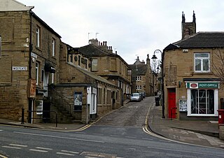
Holmfirth is a town in the Metropolitan Borough of Kirklees, West Yorkshire, England, on the A635 and A6024 in the Holme Valley, at the confluence of the River Holme and Ribble, 6 miles (9.7 km) south of Huddersfield and 14 miles (23 km) west of Barnsley. It mostly consists of stone-built cottages nestled on the eastern slopes of the Pennine hills. The boundary of the Peak District National Park is 2 miles (3.2 km) south-west of the town.

Mirfield is a town and civil parish in Kirklees, West Yorkshire, England. Historically part of the West Riding of Yorkshire, it is on the A644 road between Brighouse and Dewsbury. At the 2011 census it had a population of 19,563. Mirfield forms part of the Heavy Woollen District.

Kirklees is a metropolitan borough of West Yorkshire, England. The borough compromises of the eight towns of Batley, Birstall, Cleckheaton, Dewsbury, Heckmondwike, Holmfirth, Huddersfield, Mirfield and Slaithwaite. It is governed by Kirklees Council. Kirklees had a population of 422,500 in 2011; it is the third largest metropolitan district in England by area size, behind Doncaster and Leeds.

Meltham is a town and civil parish within the Metropolitan Borough of Kirklees, in West Yorkshire, England. It lies in the Holme Valley, below Wessenden Moor, 4+1⁄2 miles south-west of Huddersfield on the edge of the Peak District National Park. It had a population of 8,089 at the 2001 census, which was estimated to have increased to 8,600 by 2005. The population assessed at the 2011 Census was 8,534. It has 12 elected council members who meet up around every 6 weeks.
Honley is a large village and former civil parish, now in the parish of Holme Valley, in the Kirklees district, in West Yorkshire, England. Historically part of the West Riding of Yorkshire, it is situated near to Holmfirth and Huddersfield, and on the banks of the River Holme in the Holme Valley. According to the 2011 Census it had a population of 6,474, a growth of 577 from the 2001 Census

The Colne Valley is a steep sided valley on the east flank of the Pennine Hills in the English county of West Yorkshire. It takes its name from the River Colne which rises above the town of Marsden and flows eastward towards Huddersfield.

A civil parish in England is the lowest unit of local government. There are 284 civil parishes in the ceremonial county of Cumbria, with most of the county being parished. At the 2001 census, there were 359,692 people living in those 284 parishes, accounting for 73.8 per cent of the county's population.
Upperthong is a village approximately 807 feet (246 m) above sea level, near the town of Holmfirth in Holme Valley, approximately 7 miles (11 km) south of Huddersfield, West Yorkshire, England.

A civil parish is a country subdivision, forming the lowest unit of local government in England. There are 125 civil parishes in the ceremonial county of Bedfordshire, most of the county being parished: Luton is completely unparished; Central Bedfordshire is entirely parished. At the 2001 census, there were 312,301 people living in the 125 parishes, which accounted for 55.2 per cent of the county's population.

A civil parish is a subnational entity, forming the lowest unit of local government in England. There are 219 civil parishes in the ceremonial county of Lancashire; Blackpool is completely unparished; Pendle and Ribble Valley are entirely parished. At the 2001 census, there were 587,074 people living in the 219 parishes, accounting for 41.5 per cent of the county's population.

A civil parish is a subnational entity, forming the lowest unit of local government in England. There are 101 civil parishes in the ceremonial county of West Yorkshire, most of the county being unparished. At the 2001 census, there were 557,369 people living in the parishes, accounting for 26.8 per cent of the county's population.

Colne Valley is a constituency represented in the House of Commons of the UK Parliament since 2019 by Jason McCartney of the Conservative Party.

New Mill, West Yorkshire, England, is a small, semi-rural village near the town of Holmfirth. It is in the metropolitan borough of Kirklees and the civil parish of Holme Valley. The village had a population of 1,259 in the 2001 census. The village is 2 miles (3.2 km) east of Holmfirth and 6 miles (9.7 km) south of Huddersfield.

The Holme of the Holme Valley, West Yorkshire, England is a tributary of the River Colne, West Yorkshire. The source is via Digley Reservoir, fed firstly by the run-off from Brownhill Reservoir, then by Dobbs Dike. Banks along the upper valley are mostly urbanised and are in the Holme Valley civil parish.
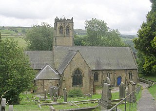
Scholes is a village and former civil parish, now in the parish of Holme Valley, in Kirklees, West Yorkshire, England. It is situated 1 mile (2 km) to the south-east and above Holmfirth, 7 miles (11 km) south-west of Huddersfield, in the Holme Valley. It has a population of 1,990. The name Scholes may have originated from the Scandinavian language meaning 'the temporary huts or sheds'.

Brockholes is a small village in West Yorkshire, England, in the administrative area of Kirklees Metropolitan Council and Holme Valley Parish Council. The village of Honley borders to the immediate north of the village and Holmfirth lies to the south. Brockholes is within the Postal district of Holmfirth.

Jackson Bridge is a small village in the civil parish of Holme Valley in the Metropolitan Borough of Kirklees in West Yorkshire, England and within the postal district of Holmfirth. It is situated next to the A616, Huddersfield to Penistone, road.

Netherthong is a village and former civil parish, now in the parish of Holme Valley, and the metropolitan borough of Kirklees in West Yorkshire, England. The village is near the town of Holmfirth, and on the B6107 road to Meltham from the main A6024 Woodhead Road through the Holme Valley from Honley to Holmfirth. It has an estimated population of 1,738 (2018).

Farnley Tyas is village in the parish of Kirkburton, in the Kirklees district, in the county of West Yorkshire, England 3 miles (4.8 km) south east of Huddersfield. It is located on a hilltop between Almondbury, Castle Hill, Thurstonland and Honley. It is mostly rural and farmland with private housing and some local authority social housing. In 1921 the parish had a population of 486.

Thongsbridge is a small village in the Kirklees district of West Yorkshire, England. It is in the semi-rural Holme Valley and the village boundaries merge into the neighbouring communities of Holmfirth, New Mill and Wooldale. According to the 2001 Census, it covers an area of 124.7 hectares.


