Holmfirth is a town in the Metropolitan Borough of Kirklees, West Yorkshire, England. It is located 6 miles (9.7 km) south of Huddersfield and 14 miles (23 km) west of Barnsley; the boundary of the Peak District National Park is 2 miles (3.2 km) to the south-west. The town is sited on the A635 and A6024 roads in the Holme Valley, at the confluence of the River Holme and Ribble. It mostly consists of stone-built cottages nestled on the eastern slopes of the Pennine hills.

Meltham is a town and civil parish within the Metropolitan Borough of Kirklees, in West Yorkshire, England. It lies in the Holme Valley, below Wessenden Moor, 5 miles south-west of Huddersfield on the edge of the Peak District National Park. It had a population of 8,089 at the 2001 census, which was estimated to have increased to 8,600 by 2005. The population assessed at the 2011 Census was 8,534. It has 12 elected council members who meet up around every 6 weeks.
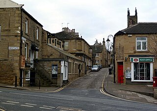
Honley is a village in the Holme Valley civil parish in Kirklees, West Yorkshire, England. Historically part of the West Riding of Yorkshire, it is situated near to Holmfirth and Huddersfield, and on the banks of the River Holme. According to the 2011 Census it had a population of 6,474, a growth of 577 from the 2001 Census

Colne Valley is a constituency represented in the House of Commons of the UK Parliament since 2024 by Paul Davies of the Labour Party.

New Mill is a village in the civil parish of Holme Valley, in the metropolitan borough of Kirklees, in West Yorkshire, England, near the town of Holmfirth. The village had a population of 1,259 in the 2001 census. The village is 2 miles (3.2 km) east of Holmfirth and 6 miles (9.7 km) south of Huddersfield.
Holme Valley, formerly Holmfirth is a large civil parish in the metropolitan borough of Kirklees in West Yorkshire, England. It has a population of 25,049, increasing to 34,680 for the two wards in the 2011 Census. Its administrative centre is in Holmfirth. Other sizeable settlements in the parish include, Brockholes, Honley and New Mill. It is named from the River Holme that runs through the parish.

The Holme of the Holme Valley, West Yorkshire, England is a tributary of the River Colne, West Yorkshire. The source is via Digley Reservoir, fed firstly by the run-off from Brownhill Reservoir, then by Dobbs Dike. Banks along the upper valley are mostly urbanised and are in the Holme Valley civil parish.

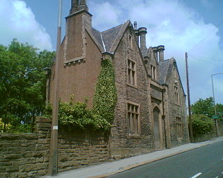
Brockholes railway station serves the village of Brockholes, near Huddersfield in West Yorkshire. It lies 4.25 miles (7 km) away from Huddersfield on the Penistone Line operated by Northern Trains.

Shepley is a village in the civil parish of Kirkburton, in Kirklees, West Yorkshire, England. It lies 8 miles (13 km) south south east of Huddersfield and 6 miles (9.7 km) north west of Penistone.

Jackson Bridge is a small village in the civil parish of Holme Valley in the Metropolitan Borough of Kirklees in West Yorkshire, England and within the postal district of Holmfirth. It is situated next to the A616, Huddersfield to Penistone, road.

Netherthong is a village and former civil parish, now in the parish of Holme Valley, and the metropolitan borough of Kirklees in West Yorkshire, England. The village is near the town of Holmfirth, and on the B6107 road to Meltham from the main A6024 Woodhead Road through the Holme Valley from Honley to Holmfirth. It has an estimated population of 1,738 (2018).
Berry Brow is a semi-rural village in West Yorkshire, England, situated about 2 miles (3 km) south of Huddersfield. It lies on the eastern bank of the Holme Valley and partially straddles the A616 road to Honley and Penistone.

The A616 is a road that links Newark-on-Trent, Nottinghamshire, to the M1 motorway at Junction 30, then reappears at Junction 35A and goes on to Huddersfield, West Yorkshire.

Thongsbridge is a small village in the Kirklees district of West Yorkshire, England. It is in the semi-rural Holme Valley and the village boundaries merge into the neighbouring communities of Holmfirth, New Mill and Wooldale. According to the 2001 Census, it covers an area of 124.7 hectares.

Honley High School is a coeducational secondary school situated on the edge of the village of Honley in the Holme Valley, West Yorkshire, England. The catchment area includes the neighbouring villages of Brockholes, Honley, Meltham and Netherton Honley High has around 1,250 pupils aged 11–16. The school houses the specialist autism provision for young people with ASD from the South Kirklees area. Honley High school ranked 825th out of 3166 schools across the country in 2019.
The Holmfirth branch line is a disused railway line that ran for 2 miles (3.2 km) from Brockholes to Holmfirth, in West Yorkshire, England. The line was built as double track as there were plans to extend the line up the Holme Valley.

Taylor Hill is a semi rural/industrial urban village of the town of Huddersfield in the English county of West Yorkshire. It lies on a hill above the A616 road to Honley and Penistone and the eastern bank of the River Holme, in the Holme Valley, approximately 1.5 miles (2 km) to the south of Lockwood, west of Newsome and to the north of Berry Brow.
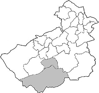
Holme Valley is a civil parish in the metropolitan borough of Kirklees, West Yorkshire, England. It contains 450 listed buildings that are recorded in the National Heritage List for England. Of these, one is listed at Grade II*, the middle of the three grades, and the others are at Grade II, the lowest grade. Holme Valley is a large parish to the south of Huddersfield, and is largely rural. The largest settlement is the small town of Holmfirth, and smaller settlements include Honley and Brockholes to the north, and New Mill, Totties, Jackson Bridge, Hepworth, Hade Edge and Burnlee to the east and south.
Holme Valley is a civil parish in the metropolitan borough of Kirklees, West Yorkshire, England. It contains 450 listed buildings that are recorded in the National Heritage List for England. Of these, one is listed at Grade II*, the middle of the three grades, and the others are at Grade II, the lowest grade. Holme Valley is a large parish to the south of Huddersfield, and is largely rural. The largest settlement is the small town of Holmfirth, and smaller settlements include Honley and Brockholes to the north, and New Mill, Totties, Jackson Bridge, Hepworth, Hade Edge and Burnlee to the east and south.