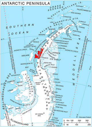
Northeast Glacier is a steep, heavily crevassed glacier, 13 nautical miles long and 5 nautical miles wide at its mouth, which flows from McLeod Hill westward and then south-westwards into Marguerite Bay between the Debenham Islands and Roman Four Promontory, on the west coast of Graham Land, Antarctica.

Arrowsmith Peninsula is a cape about 40 miles (64 km) long on the west coast of Graham Land, west of Forel Glacier, Sharp Glacier and Lallemand Fjord, and northwest of Bourgeois Fjord, with Hanusse Bay lying to the northwest. It was surveyed by the Falkland Islands Dependencies Survey (FIDS) in 1955-58 and named for Edwin Porter Arrowsmith, Governor of the Falkland Islands.
The Airy Glacier is a glacier 20 nautical miles (37 km) long and 6 nautical miles (11 km) wide, flowing west to the northeast portion of Forster Ice Piedmont, near the west coast of the Antarctic Peninsula.

Finsterwalder Glacier is a glacier on the northwest side of Hemimont Plateau, 2 nautical miles wide and 10 nautical miles long, flowing southwest from the central plateau of Graham Land, Antarctica, toward the head of Lallemand Fjord. Its mouth lies between the mouths of Haefeli Glacier and Klebelsberg Glacier, the three glaciers merging with Sharp Glacier where the latter enters the fjord. It was first surveyed from the plateau in 1946–47 by the Falkland Islands Dependencies Survey, and named by them for Sebastian Finsterwalder and his son, Richard Finsterwalder, German glaciologists.

Prospect Point is a headland at the west extremity of Velingrad Peninsula on Graham Coast in Graham Land, four kilometres south of Ferin Head and immediately east of the Fish Islands. Roughly charted by the British Graham Land Expedition (BGLE) under Rymill, 1934–37. Photographed by Hunting Aerosurveys Ltd. in 1956–57. The name was suggested in 1957 by E. P. Arrowsmith, Governor of the Falkland Islands.

Beascochea Bay is a bay, 10 nautical miles (19 km) long and 5 nautical miles (9 km) wide, indenting the Graham Coast of Graham Land, Antarctica, between Kyiv Peninsula and Barison Peninsula, and entered south of Cape Perez. The glaciers Lever, Funk, Cadman, Talev and Butamya feed the bay.

Bigo Bay is a bay 8 nautical miles (15 km) long and 6 nautical miles (11 km) wide, indenting the west coast of Graham Land between Cape Garcia and Magnier Peninsula surmounted by the Magnier Peaks and Lisiya Ridge.
Bryan Coast is that portion of the coast of Antarctica along the south shore of the Bellingshausen Sea between Pfrogner Point and the northern tip of the Rydberg Peninsula. To the west is Eights Coast, and to the east is English Coast.

Coblentz Peak is a peak rising at the north side of the head of Holtedahl Bay, in Chiren Heights, Velingrad Peninsula, on the west coast of Graham Land in Antarctica. It was photographed by Hunting Aerosurveys Ltd in 1956–57 and was mapped from these photos by the Falkland Islands Dependencies Survey. It was named by the UK Antarctic Place-Names Committee in 1959 for William W. Coblentz of the U.S. National Bureau of Standards, whose work on the transmissive properties of tinted glass has contributed to the design of satisfactory snow goggles.

Darbel Bay is a bay 25 nautical miles (50 km) wide, indenting the west coast of Graham Land between Stresher Peninsula and Pernik Peninsula. Entered southwest of Cape Bellue and northeast of Cape Rey. The glaciers Widmark Ice Piedmont, Cardell, Erskine, Hopkins, Drummond, Widdowson, McCance, Solun, and Škorpil feed the bay.

Trooz Glacier is an Antarctic glacier. Situated on the Kyiv Peninsula in Graham Land, 1.5 nautical miles (2.8 km) wide at its mouth and some 15 nautical miles (28 km) long, it flows west into the north part of Collins Bay. It was Discovered by the French Antarctic Expedition, 1908–10 and Named for J. de Trooz, Belgian Minister of the Interior and Public Instruction, who was instrumental in procuring funds for the publication of the scientific results of the Belgian Antarctic Expedition, 1897–99. This application was suggested by the Advisory Committee on Antarctic Names (US-ACAN) because of duplication of the name Trooz for what is now known as Cape Perez.

Ferin Head is a headland 4 nautical miles (7 km) north of the entrance to Holtedahl Bay, in the northwest of Velingrad Peninsula on the Graham Coast of Graham Land, Antarctica. It was discovered by the French Antarctic Expedition, 1908–10, who from a distant position in Pendleton Strait charted this feature as an island, which Jean-Baptiste Charcot named for A. Ferin, French Vice-consul at Ponta Delgada in the Azores. The British Graham Land Expedition (BGLE) under John Rymill, 1934–37, charted this coast and correlated their work with that of Charcot. Ferin Head, as here applied, is in accord with the BGLE interpretation.

Girard Bay is a bay 2 nautical miles (4 km) long and 1 nautical mile (2 km) wide, indenting the northwest coast of Kyiv Peninsula, Graham Land, between Cape Cloos and Mount Scott. It was discovered by the Belgian Antarctic Expedition, 1897–99, and was named by the French Antarctic Expedition, 1903–05, under Jean-Baptiste Charcot, for Jules Girard of the Paris Société de Géographie.

Hugi Glacier is a glacier flowing northward into the head of Holtedahl Bay southwest of Rasnik Peak, on the west coast of Graham Land, Antarctica. It was charted by the British Graham Land Expedition under John Rymill, 1934–37, and was named by the UK Antarctic Place-Names Committee in 1959 for Franz Joseph Hugi, a Swiss teacher who was called the "father of winter mountaineering," and was author of two pioneer works on glacier phenomena.
McClary Glacier is a glacier 10 nautical miles (19 km) long and 2 nautical miles (4 km) wide on the west coast of Graham Land, Antarctica. It flows southwest along the north side of Butson Ridge into Marguerite Bay between Cape Calmette and the Debenham Islands. The glacier was first roughly surveyed by the British Graham Land Expedition, 1936–37, and resurveyed by the Falkland Islands Dependencies Survey, 1946–50. It was named by the UK Antarctic Place-Names Committee for George B. McClary, father of Nelson McClary, mate on the Port of Beaumont during the Ronne Antarctic Research Expedition, 1947–48.

Hotine Glacier is a glacier 10 nautical miles (19 km) long which is divided at its mouth by Mount Cloos, flowing west into both Deloncle Bay and Girard Bay on Kyiv Peninsula, on the west coast of Graham Land, Antarctica. It was first charted by the Belgian Antarctic Expedition under Gerlache, 1897–99, and was named by the UK Antarctic Place-Names Committee in 1959 for Brigadier Martin Hotine, Director of Overseas Surveys.

Lens Peak is a peak at the south side of Holtedahl Bay just east of Conway Island, on the northeast coast of Stresher Peninsula on the west coast of Graham Land, Antarctica. It was photographed by Hunting Aerosurveys Ltd in 1956–57, and mapped from these photos by the Falkland Islands Dependencies Survey. The peak was named by the UK Antarctic Place-Names Committee in 1960 from association with a group of features in the area commemorating pioneers of research on snow blindness and the design of snow goggles.

Leroux Bay is a bay 9 nautical miles (17 km) long in a northwest–southeast direction and averaging 5 nautical miles (9 km) wide, between Nunez Point and the narrow Magnier Peninsula surmounted by the Magnier Peaks and Lisiya Ridge, along the west coast of Graham Land, Antarctica. The glaciers Chernomen, Luke and Muldava feed the bay.

Lever Glacier is a glacier, 1.5 nautical miles (3 km) wide at its mouth and at least 6 nautical miles (11 km) long, flowing west-northwest, then west-southwest into the head of the northern arm of Beascochea Bay north of Chorul Peninsula, on the west coast of Graham Land, Antarctica. The glacier was first sighted and roughly surveyed in 1909 by the French Antarctic Expedition. It was resurveyed in 1935 by the British Graham Land Expedition (BGLE) under John Rymill, and named in 1954 for William Lever, 2nd Viscount Leverhulme, who contributed toward the cost of the BGLE.

Stresher Peninsula is the predominantly ice-covered rectangular peninsula 30 km wide and projecting 24 km northwestwards from Graham Land, Antarctic Peninsula. It is bounded by Holtedahl Bay to the northeast, Auvert Bay to the northwest and Darbel Bay to the southwest. Its west extremity Cape Bellue separates Graham Coast to the northeast from Loubet Coast to the southwest. Lawson Peak is a peak 3.5 nautical miles (6 km) southeast of Cape Evensen.


