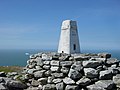
Holyhead Mountain

Last updated

Holyhead Mountain
Holyheadmountain.jpg
Holyhead Mountain from the town's New Park
Highest point
Elevation 220 m (720 ft)
Prominence 220 m (720 ft)
Parent peak none - HP Holy Island
Listing Marilyn, council top
Coordinates 53°18′47″N4°40′35″W / 53.31297°N 4.6763°W / 53.31297; -4.6763
Geography
Isle of Anglesey UK relief location map.jpg
Red triangle with thick white border.svg
Holyhead Mountain
OS grid SH218829
Topo map OS Landranger 114

Holyhead Mountain (Welsh Mynydd Twr, from mynydd 'mountain, unenclosed land' and twr 'a heap, pile') [1] is the highest point on Holy Island, Anglesey, and in the county of Anglesey, north Wales. It lies about two miles west of the town of Holyhead, and slopes steeply down to the Irish Sea on two sides. Ireland can be seen from here on a clear day and the cliffs below are an important site for seabirds.

Contents

Description

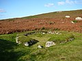
Holyhead Mountain is at the northern end of Holy Island, Anglesey, jutting out into the Irish Sea. At 722 feet (220 m), it is the highest point in the county of Anglesey, being higher than Bodafon Mountain (584 feet (178 m)) on the main island. [2] On the east side is the site of a late Roman watchtower called Caer y Twr ('the fort of the pile/heap'). Holyhead Mountain also has the remains of a group of Iron Age huts near its foot. This shows evidence of being occupied in the middle part of the Stone Age, the Neolithic Age, the Bronze Age and the Iron Age. There are traces of field systems and the bases of dry-stone walls of twenty huts, and there are a number of standing stones in the vicinity. [3]

The summit is rocky, quartzite, and the slopes clad in heather. There is an Iron Age hillfort called Caer y Twr. The material for the breakwater at the port of Holyhead was quarried from the limestone areas of the northeastern side of the island, with seven million tons of limestone being removed from long-established [4] quarries to form the longest breakwater in Britain, at nearly one and a half miles (2.4 km) long. There are also the remains of a brickworks, which closed in 1973. Specialist bricks produced here were also used in construction of the breakwater. [5]

Holyhead Mountain attracts many visitors, and it is close to South Stack lighthouse; many people come to see the variety of birds that nest along the cliff faces near South Stack. Views from the summit are extensive, especially to the west, where the Wicklow Mountains in Ireland can often be seen across the Irish Sea on clear days. Birds that nest here include Atlantic puffins, stonechats and Eurasian oystercatchers, and grey seals can be seen offshore during the summer. [5]

Related Research Articles

<span class="mw-page-title-main">Holyhead</span> Port town in Isle of Anglesey, Wales

Holyhead is the largest town and a community in the county of Isle of Anglesey, Wales, with a population of 13,659 at the 2011 census. Holyhead is on Holy Island, bounded by the Irish Sea to the north, and is separated from Anglesey island by the narrow Cymyran Strait and was originally connected to Anglesey via the Four Mile Bridge.

<span class="mw-page-title-main">Holy Island, Anglesey</span> Island, part of Wales, United Kingdom

Holy Island is an island on the western side of the larger Isle of Anglesey, Wales, from which it is separated by the Cymyran Strait. It is called "Holy" because of the high concentration of standing stones, burial chambers, and other religious sites on the small island. The alternative English name of the island is Holyhead Island. According to the 2011 UK Census, the population was 13,659, of whom 11,431 (84%) lived in the largest town, Holyhead.

<span class="mw-page-title-main">Penmaenmawr</span> Human settlement in Wales

Penmaenmawr is a town and community in Conwy County Borough, Wales, which was formerly in the parish of Dwygyfylchi and the traditional county of Caernarfonshire. It is on the North Wales coast between Conwy and Llanfairfechan and was an important quarrying town, though quarrying is no longer a major employer. The population of the community was 4,353 in 2011, including Dwygyfylchi and Capelulo. The town itself having a population of 2,868 (2011).

<span class="mw-page-title-main">South Stack</span> Island off northwest Anglesey, Wales

South Stack is an island situated just off Holy Island on the northwest coast of Anglesey, Wales.

<span class="mw-page-title-main">Mynydd Bodafon</span> Hill (177.6m) on Anglesey, Wales

Mynydd Bodafon (Bodafon Mountain) is a small collection of peaks including the Arwydd (The Sign or signal) which is the highest point on the island of Anglesey (although not in the county of Anglesey — see Holyhead Mountain). It lies about 2+12 miles west of the coastal town of Moelfre and ⅔ of a mile south-west of the hamlet of Brynrefail. The meaning of Bodafon is obscure. Bod is a common placename element meaning 'dwelling' and afon here is probably a corruption of the personal name A(e)ddan (afon is Welsh for 'river' but topography rules that out).

<span class="mw-page-title-main">Rhosneigr</span> Village in Anglesey, Wales

Rhosneigr is a village in the south-west of Anglesey, north Wales. It is situated on the A4080 road some 10 km south-east of Holyhead, and is on the Anglesey Coastal Path. From the clock at the centre of the village can be seen RAF Valley and Mynydd Twr. The major towns of Holyhead and Llangefni and the city of Bangor are all within easy travelling distance. It is the most expensive place to live in Anglesey in terms of house prices.

<span class="mw-page-title-main">Salt Island, Anglesey</span> Island in Anglesey, Wales, UK

Salt Island is joined to Holy Island, Anglesey, in North Wales. It is a natural provider of shelter for the town's Old Harbour from the Irish Sea and is part of the Port of Holyhead.

<span class="mw-page-title-main">Caer Gybi (fort)</span> Roman fortlet remains in Anglesey, Wales

Caer Gybi was a small fortlet in Roman Wales in the Roman province of Britannia Superior. Its name in Latin is unknown. Today it stands at the centre of Holyhead in the Welsh county of Anglesey. Holyhead is named Caergybi in Welsh, after the fort.

<span class="mw-page-title-main">Mynydd y Dref</span>

Mynydd y Dref or Conwy Mountain is a hilly area to the west of the town of Conwy, in Wales. To the north it overlooks the sea of Conwy Bay, and to the south lie the foothills of the Carneddau range of mountains, of which it forms a part. Mynydd y Dref is the remains of an ancient volcano that erupted about 450 million years ago.

<span class="mw-page-title-main">Holyhead Mountain Hut Circles</span> Iron age settlement on Holy island, Wales

The Holyhead Mountain Hut Circles named in Welsh: Tŷ Mawr / Cytiau'r Gwyddelod, literally meaning Big house or "Irishmen's Huts". are the remains of a group of Celtic Iron Age huts near Trearddur on Holy Island, Anglesey, Wales. The site is under the care of Cadw and can be visited all year round. The construction of these huts is very similar to those at Din Lligwy, having thick stone walls.

<span class="mw-page-title-main">Anglesey</span> Island county in Wales

The Isle of Anglesey is a county off the north-west coast of Wales. It is named after the island of Anglesey, which makes up 94% of its area, but also includes Holy Island and some islets and skerries.

<span class="mw-page-title-main">Mynydd Llangatwg</span> Hill (528.9m) in Powys, Wales

Mynydd Llangatwg or Llangattock Mountain is a hill in the Brecon Beacons National Park in the county of Powys, south Wales. It is named from the village of Llangatwg which sits in the valley of the River Usk to the north of it. It is essentially an undulating plateau rising in the west to a height of 530 metres (1,740 ft) at grid reference SO171157 and in the east to a height of 529 metres (1,736 ft) at Hen Dy-aderyn / Twr Pen-cyrn. This spot is marked by a trig point. The shallow pool of Pwll Gwy-rhoc sits in a broad depression towards the northern edge of the plateau whilst a smaller pool frequently occupies a large shakehole a few hundred metres to its west. The hill forms an impressive northern scarp overlooking the Usk valley and commonly referred to as the Llangattock Escarpment. Its southern margins are more subdued. Its eastern end is defined by the drops into the Clydach Gorge. Beyond the B4560 to the west the hill merges with Mynydd Llangynidr which has a similar character.

<span class="mw-page-title-main">Caer y Twr</span> Hillfort in Anglesey, Wales

Caer y Twr is an Iron Age hillfort atop the summit of the Holyhead Mountain in Anglesey, Wales.

<span class="mw-page-title-main">Roman conquest of Anglesey</span> Two Roman invasions of Anglesey during the mid 1st century

Anglesey, which was recorded in Latin as Mona and is still known as Môn in modern Welsh, was a place of resistance to Roman rule because it was an important centre for the Celtic Druids and their religious practices. The Roman conquest of Anglesey refers to two separate invasions of Anglesey in North West Wales that occurred during the early decades of the Roman conquest of Britain in the 1st century CE. The first invasion of North Wales began after the Romans had subjugated much of southern Britain. It was led by the Provincial governor of Britannia, Suetonius Paulinus, who led a successful assault on the island in 60–61 CE, but had to withdraw because of the Boudican revolt. In 77 CE, Gnaeus Julius Agricola's thorough subjugation of the island left it under Roman rule until the end of Roman rule in Britain in the early 5th century CE.

<span class="mw-page-title-main">Holyhead Breakwater</span> Longest breakwater in the United Kingdom

Holyhead Breakwater is situated at the north-western end of Holyhead in Anglesey in North Wales. The Victorian structure, which is 1.7 miles (2.7 km) long, is the longest breakwater in the United Kingdom. The breakwater, which is accessible in good weather, has a promenade on top which leads out to the Holyhead Breakwater Lighthouse.

<span class="mw-page-title-main">Parc a'r Mynydd</span> Area and community ward in Holyhead, UK

Parc a'r Mynydd is an area and community electoral ward in the town of Holyhead, Anglesey, Wales.

The geology of Anglesey, the largest (714 km2) island in Wales is some of the most complex in the country. Anglesey has relatively low relief, the 'grain' of which runs northeast–southwest, i.e. ridge and valley features extend in that direction reflecting not only the trend of the late Precambrian and Palaeozoic age bedrock geology but also the direction in which glacial ice traversed and scoured the island during the last ice age. It was realised in the 1980s that the island is composed of multiple terranes, recognition of which is key to understanding its Precambrian and lower Palaeozoic evolution. The interpretation of the island's geological complexity has been debated amongst geologists for decades and recent research continues in that vein.

<span class="mw-page-title-main">Coastline of Wales</span> Sea-bounded areas of Wales

The coastline of Wales extends from the English border at Chepstow westwards to Pembrokeshire then north to Anglesey and back eastwards to the English border once again near Flint. Its character is determined by multiple factors, including the local geology and geological processes active during and subsequent to the last ice age, its relative exposure to or shelter from waves, tidal variation and the history of human settlement and development which varies considerably from one place to another. The majority of the coast east of Cardiff in the south, and of Llandudno in the north, is flat whilst that to the west is more typically backed by cliffs. The cliffs are a mix of sandstones, shales and limestones, the erosion of which provides material for beach deposits. Of the twenty-two principal areas which deliver local government in Wales, sixteen have a coastline, though that of Powys consists only of a short section of tidal river some distance from the open sea. Its length has been estimated at 1,680 miles (2,700 km).

The geology of Pembrokeshire in Wales inevitably includes the geology of the Pembrokeshire Coast National Park which extends around the larger part of the county's coastline and where the majority of rock outcrops are to be seen. Pembrokeshire's bedrock geology is largely formed from a sequence of sedimentary and igneous rocks originating during the late Precambrian and the Palaeozoic era, namely the Ediacaran, Cambrian, Ordovician, Silurian, Devonian and Carboniferous periods, i.e. between 635 and 299 Ma. The older rocks in the north of the county display patterns of faulting and folding associated with the Caledonian Orogeny. On the other hand, the late Palaeozoic rocks to the south owe their fold patterns and deformation to the later Variscan Orogeny.

References

  1. Pierce, Gwynedd O.; Roberts, Tomos (1999). "Mynydd Twr/Mynydd Tŵr". Ar draws gwlad 2 : ysgrifau ar enwau lleoedd. Llanrwst: Gwasg Carreg Gwalch. p. 69. ISBN   0-86381-556-1. OCLC   41159255.
  2. 114 Anglesey (Map). 1:50000. Landranger. Ordnance Survey.
  3. Breverton, Terry (2013). Wales' 1000 Best Heritage Sites. Amberley Publishing Limited. p. 86. ISBN   978-1-4456-2013-8.
  4. Campbell, Stewart; Wood, Margaret; Windley, Brian (2014). Footsteps through time: the rocks and landscape of Anglesey Explained. GeoMôn.
  5. 1 2 Plant, Steve (2014). A Wander Around the Coast of Wales. Fast-Print Publishing. pp. 68–70. ISBN   978-1-78035-761-4.