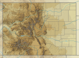
The South Platte River is one of the two principal tributaries of the Platte River. Flowing through the U.S. states of Colorado and Nebraska, it is itself a major river of the American Midwest and the American Southwest/Mountain West. Its drainage basin includes much of the eastern flank of the Rocky Mountains in Colorado, much of the populated region known as the Colorado Front Range and Eastern Plains, and a portion of southeastern Wyoming in the vicinity of the city of Cheyenne. It joins the North Platte River in western Nebraska to form the Platte, which then flows across Nebraska to the Missouri. The river serves as the principal source of water for eastern Colorado. In its valley along the foothills in Colorado, it has permitted agriculture in an area of the Colorado Piedmont and Great Plains that is otherwise arid.

Lake Mead is a reservoir formed by the Hoover Dam on the Colorado River in the Southwestern United States. It is located in the states of Nevada and Arizona, 24 mi (39 km) east of Las Vegas. It is the largest reservoir in the US in terms of water capacity. Lake Mead provides water to the states of Arizona, California, and Nevada as well as some of Mexico, providing sustenance to nearly 20 million people and large areas of farmland.
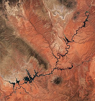
Lake Powell is a reservoir on the Colorado River in Utah and Arizona, United States. It is a major vacation destination visited by approximately two million people every year. It holds 24,322,000 acre-feet (3.0001×10¹⁰ m3) of water when full, second in the United States to only Lake Mead - though Lake Mead has fallen below Lake Powell in size several times during the 21st century in terms of volume of water, depth and surface area.
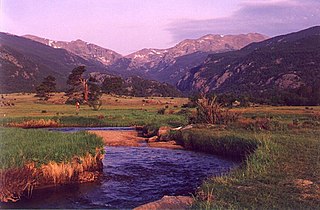
The Big Thompson River is a tributary of the South Platte River, approximately 78 miles (126 km) long, in the U.S. state of Colorado. Originating in Forest Canyon in Rocky Mountain National Park, the river flows into Lake Estes in the town of Estes Park and then through Big Thompson Canyon. It includes four crossings/bridges which are listed on the U.S. National Register of Historic Places.

Cherry Creek is a tributary of the South Platte River, 48.0 miles (77.2 km) long, in Colorado in the United States.

Parker Dam is a concrete arch-gravity dam that crosses the Colorado River 155 miles (249 km) downstream of Hoover Dam. Built between 1934 and 1938 by the Bureau of Reclamation, it is 320 feet (98 m) high, 235 feet (72 m) of which are below the riverbed (the deep excavation was necessary in order to reach the bedrock on which the foundation of the dam was built), making it the deepest dam in the world. The portion of the dam above the foundation stands 85 feet (25.9 m) tall, making it the only dam in the world that stands more underground than above ground. The dam's primary functions are to create a reservoir, and to generate hydroelectric power. The reservoir behind the dam is called Lake Havasu and can store 647,000 acre⋅ft (798,000,000 m3; 2.11×10¹¹ US gal; 1.76×10¹¹ imp gal). The dam straddles the Arizona-California state border at the narrows the river passes through between the Whipple Mountains in San Bernardino County, California and the Buckskin Mountains in La Paz County, Arizona.

Lake Havasu is a large reservoir formed by Parker Dam on the Colorado River, on the border between San Bernardino County, California and Mohave County, Arizona. Lake Havasu City sits on the Arizonan side of the lake with its Californian counterpart of Havasu Lake directly across the lake. The reservoir has an available capacity of 619,400 acre-feet (0.7640 km3). The concrete arch dam was built by the United States Bureau of Reclamation between 1934 and 1938. The lake's primary purpose is to store water for pumping into two aqueducts. Prior to the dam construction, the area was home to the Mojave people. The lake was named after the Mojave word for blue. In the early 19th century, it was frequented by beaver trappers. Spaniards also began to mine the areas along the river.
Pactola Lake is the largest and deepest reservoir in the Black Hills, located 15 miles west of Rapid City, South Dakota, United States. Constructed in 1952, the dam and waters are managed by the Bureau of Reclamation, with the surrounding land managed by the US Forest Service as part of Black Hills National Forest, which operates a visitor center located on the south side of the dam. Facilities include campgrounds, hiking trails, picnic areas, cliffs, and a beach.

Dillon Reservoir, sometimes referred to as Lake Dillon, is a large fresh water reservoir located in Summit County, Colorado, United States, south of I-70 and bordered by the towns of Frisco, Silverthorne, and Dillon. It is a reservoir for the city of Denver, and its waters are under the control of Denver Water. Popular ski areas are close to the reservoir, including Copper Mountain, Keystone, Arapahoe Basin, and Breckenridge.

Kentucky Dam is a hydroelectric dam on the Tennessee River on the county line between Livingston and Marshall counties in the U.S. state of Kentucky. The dam is the lowermost of nine dams on the river owned and operated by the Tennessee Valley Authority, which built the dam in the late 1930s and early 1940s to improve navigation on the lower part of the river and reduce flooding on the lower Ohio and Mississippi rivers. It was a major project initiated during the New Deal of President Franklin D. Roosevelt's administration, to invest in infrastructure to benefit the country. The dam impounds the Kentucky Lake of 160,000 acres (65,000 ha), which is the largest of TVA's reservoirs and the largest artificial lake by area in the Eastern United States. It was designated as an National Historic Civil Engineering Landmark by the American Society of Civil Engineers in 1996 and listed on the National Register of Historic Places in 2017.

Navajo Lake is a reservoir located in San Juan County and Rio Arriba County in northwestern New Mexico, in the southwestern United States. Portions of the reservoir extend into Archuleta County in southern Colorado. The lake is part of the Colorado River Storage Project, which here manages the upper reaches of the San Juan River, storing and releasing water that is used locally for irrigation, or ultimately reaching the Colorado River in Utah. Water is impounded in Navajo Lake by the earth- and rock-filled Navajo Dam, 3,800 feet (1,200 m) long and 400 feet (120 m) high, completed in 1962. The 15,600-acre (63 km2) lake is over 25 miles (40 km) long and lies at an elevation of up to 6,085 feet (1,855 m).

Chatfield State Park is a state park located in Douglas and Jefferson counties of Colorado, United States. The park centers on Chatfield Reservoir, a 1,423 acre surface area lake fed by the South Platte River and two other creeks, including Plum Creek.

Rampart Reservoir is a reservoir 12 miles northwest of the city of Colorado Springs, Colorado in the Pike National Forest. The reservoir supplies the domestic drinking water for the city of Colorado Springs and serves as a recreation area for boaters, mountain bikers, and hikers.
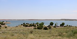
Lake Pueblo State Park is a state park located in Pueblo County, Colorado. It includes 60 miles (97 km) of shoreline and 10,000 acres (40 km2) of land. Activities it offers include two full-service marinas, recreational fishing, hiking, camping and swimming at a special swim beach.

Ruedi Reservoir is a reservoir on the Western Slope of the Continental Divide on the Fryingpan River. It sits about 15 miles (24 km) upstream of the town of Basalt, Colorado, near Aspen. The reservoir is located within the White River National Forest, and straddles the county line between Pitkin County and Eagle County.
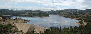
Gross Reservoir, located in Boulder County, Colorado, is owned and operated by Denver Water. Completed in 1954, the reservoir has a surface area of 440 acres (180 ha), and the spillway sits at 7,225 feet (2,202 m) elevation. The reservoir is undergoing an expansion project.

La Jara Reservoir is a reservoir in Conejos County, Colorado. Located 24 miles west of the town of La Jara, Colorado, the reservoir lies high in the San Juan Mountains. The rocky dirt road to the reservoir is difficult, and the reservoir lies about 15 miles from the nearest paved road. The fishing is poor, but the area surrounding the reservoir is popular with deer, elk, and waterfowl hunters.

Black Lake is a reservoir at Vail Pass in Eagle County, Colorado. The reservoir collects and stores water for the Eagle River Water & Sanitation District. It lies at an elevation of over 10,000 feet and sits alongside Interstate 70.

Homestake Creek is a tributary of the Eagle River in Eagle County, Colorado. Homestake Dam impounds one of the creek's tributaries, Middle Fork Homestake Creek. Homestake Creek itself begins just below the dam, at the confluence of its east and middle forks.