Shoesmith Glacier is the largest glacier on Horseshoe Island, flowing westward into both Lystad Bay and Gaul Cove. Named by United Kingdom Antarctic Place-Names Committee (UK-APC) in 1958 in association with Horseshoe Island.

Beacon Head is a small headland at the north side of the entrance to Lystad Bay on Horseshoe Island, off Graham Land. It was so named by the UK Antarctic Place-Names Committee because a timber beacon built on the headland by Argentines was used during the survey on Horseshoe Island by the Falkland Islands Dependencies Survey in 1955–57.
Bibby Point is a steep rocky headland with snow slopes falling away inland, at the northeast corner of Brandy Bay, James Ross Island. It was named by the UK Antarctic Place-Names Committee for John S. Bibby, Falkland Islands Dependencies Survey geologist at Hope Bay, 1958–59.
Blackface Point is a rocky and precipitous headland 3 nautical miles (6 km) northwest of Cape Freeman on the east coast of Graham Land. The point was photographed by the United States Antarctic Service, 1939–41, and mapped by the Falkland Islands Dependencies Survey, 1947–48. It was named by the UK Antarctic Place-Names Committee in description of the extremely black rock exposed at the end of the point.
Bongrain Point is a headland which forms the south side of the entrance to Dalgliesh Bay on the west side of Pourquoi Pas Island, off the west coast of Graham Land. It was surveyed in 1936 by the British Graham Land Expedition under John Rymill, and re-surveyed in 1948 by the Falkland Islands Dependencies Survey, who named the point for Maurice Bongrain, surveyor and First Officer of the Pourquoi Pas, the ship of the French Antarctic Expedition, 1908–10, who was responsible for the first surveys of the area.
Boreal Point is a headland forming the west side of Rockpepper Bay, along the north coast of Joinville Island. It was surveyed by the Falkland Islands Dependencies Survey in 1953–54. The feature was so named by the UK Antarctic Place-Names Committee because of its position on the north ("boreal") coast of Joinville Island.

Bottrill Head is a rugged headland on the east side of Bourgeois Fjord which forms the southwest extremity of German Peninsula and the north side of the entrance to Dogs Leg Fjord in Fallières Coast, on the west side of Graham Land, Antarctica. It was first surveyed in 1936 by the British Graham Land Expedition (BGLE) under John Rymill. The headland was resurveyed in 1948 by the Falkland Islands Dependencies Survey (FIDS) who named it for Harold Bottrill, Chairman of the Board of Directors, later General Manager, of Maclean and Stapledon S.A., shipping agents at Montevideo, who gave great assistance to the BGLE, 1934–37, and to FIDS, 1943–48.
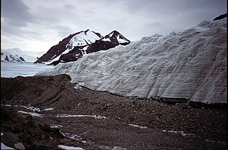
Mount Breaker is a mountain with double summits, the eastern summit being, at 880 metres (2,890 ft), the highest on Horseshoe Island, off Graham Land. The name was given by the United Kingdom Antarctic Place-Names Committee in 1958 and is descriptive; the two summits are separated by a shallow col and, when seen from the west, resemble a breaking wave.

Caution Point is a headland 4 nautical miles (7 km) northeast of Mount Birks, on the north side of the entrance to Spillane Fjord, which marks the east end of Austa Ridge that forms the north wall of Crane Glacier, on the east coast of Graham Land. It was photographed from the air by Sir Hubert Wilkins on a flight of December 20, 1928, and named by the Falkland Islands Dependencies Survey who charted it in 1947.
Kohler Head is a small headland on the northeast side of Whitmer Peninsula, on the coast of Victoria Land, Antarctica. It was mapped by the United States Geological Survey from surveys and U.S. Navy air photos, 1957–62. The Advisory Committee on Antarctic Names named the headland after John L. Kohler, U.S. Navy, a construction electrician at McMurdo Station, 1965–66 and 1966–67.

Forbes Glacier is a glacier which flows from Hemimont Plateau west into the northeast corner of Square Bay, on the west coast of Graham Land, Antarctica. It is 10 nautical miles (19 km) long, 4 nautical miles (7 km) wide in its central part, and narrows to 2 nautical miles (4 km) at its mouth. The lower reaches of the glacier were first surveyed in 1936 by the British Graham Land Expedition under John Rymill. The survey was completed in 1946–48 by the Falkland Islands Dependencies Survey who named the glacier for James David Forbes, a Scottish physicist who was noted for his pioneer works on glaciology.

Gaul Cove is a cove indenting the northeast side of Horseshoe Island, off the coast of Graham Land, Antarctica. It was named by the UK Antarctic Place-Names Committee for Kenneth M. Gaul, first leader of the Falkland Islands Dependencies Survey Horseshoe Island station in 1955.
Longridge Head is a headland at the north side of Whistling Bay on Arrowsmith Peninsula, Antarctica, marking the south end of a small coastal ridge which extends 3 nautical miles (6 km) northward along the west coast of Graham Land. It was first sighted by members of the Fourth French Antarctic Expedition under Jean-Baptiste Charcot who roughly charted this area in 1909. The name is descriptive and was applied by the Falkland Islands Dependencies Survey who surveyed the headland in 1948.
Headland Peak is a peak rising to 875 metres (2,870 ft) on the north side of Geikie Glacier, at the head of Cumberland West Bay, South Georgia. It was named by the UK Antarctic Place-Names Committee for Robert K. Headland, a British Antarctic Survey biological assistant at Grytviken, 1977–80 and 1981–82. He was curator of the Scott Polar Research Institute from 1987.

Heitō Glacier is a small glacier draining westward along the south side of Mount Heitō in the southern part of the Langhovde Hills, Queen Maud Land, Antarctica. It was mapped from surveys and air photos by the Japanese Antarctic Research Expedition (JARE), 1957–62, and was named Heitō-hyoga for its proximity to Mount Heitō by JARE Headquarters in 1973.
Tickell Head is a headland forming the east side of Bridger Bay on the north coast of Coronation Island, in the South Orkney Islands. First seen in December 1821 in the course of the joint cruise by Captain Nathaniel Palmer, American sealer, and Captain George Powell, British sealer. Surveyed by the Falkland Islands Dependencies Survey (FIDS) in 1956-58 and named by the United Kingdom Antarctic Place-Names Committee (UK-APC) in 1959 for William L.N. Tickell, FIDS meteorologist at Signy Island in 1955 and leader at that station in 1956.
Tindal Bluff is a rocky headland rising to 800 m between the terminus of Fricker Glacier and Monnier Point on the east coast of Graham Land. This coastal area was photographed by several American expeditions: United States Antarctic Service (USAS), 1939–41; Ronne Antarctic Research Expedition (RARE), 1947–48; U.S. Navy photos, 1968. Mapped by Falkland Islands Dependencies Survey (FIDS), 1947–48. Named by United Kingdom Antarctic Place-Names Committee (UK-APC) for Ronald Tindal, General Assistant with the British Antarctic Survey (BAS) Larsen Ice Shelf party in 1963-64.
Landauer Point is a point on the east coast of Adelaide Island, marking the west side of the north entrance to Tickle Channel in Graham Land, Antarctica. It was mapped by the Falkland Islands Dependencies Survey from air photos taken by the Ronne Antarctic Research Expedition, 1947–48, and the Falkland Islands and Dependencies Aerial Survey Expedition, 1956–57. The point was named by the UK Antarctic Place-Names Committee for Joseph K. Landauer, an American physicist who has studied the mechanical properties of ice and glacier flow.


