
Mount Hood, also known as Wy'east, is an active stratovolcano in the Cascade Range and is a member of the Cascade Volcanic Arc. It was formed by a subduction zone on the Pacific Coast and rests in the Pacific Northwest region of the United States. It is located about 50 mi (80 km) east-southeast of Portland, on the border between Clackamas and Hood River counties, and forms part of the Mount Hood National Forest. Much of the mountain outside the ski areas is part of the Mount Hood Wilderness. With a summit elevation of 11,249 ft, it is the highest mountain in the U.S. state of Oregon and is the fourth highest in the Cascade Range. Ski areas on the mountain include Timberline Lodge ski area which offers the only year-round lift-served skiing in North America, Mount Hood Meadows, Mount Hood Skibowl, Summit Ski Area, and Cooper Spur ski area. Mt. Hood attracts an estimated 10,000 climbers a year.

The Mount Baker–Snoqualmie National Forest in Washington is a National Forest extending more than 140 miles (230 km) along the western slopes of the Cascade Range from the Canada–US border to the northern boundary of Mount Rainier National Park. It is administered by the United States Forest Service, which has headquarter offices for this forest in Everett. Local ranger district offices are in North Bend and Skykomish.

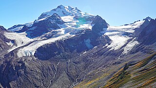
Glacier Peak or Dakobed is the most isolated of the five major stratovolcanoes of the Cascade Volcanic Arc in the U.S state of Washington. Located in the Glacier Peak Wilderness in Mount Baker–Snoqualmie National Forest, the volcano is visible from the west in Seattle, and from the north in the higher areas of eastern suburbs of Vancouver such as Coquitlam, New Westminster and Port Coquitlam. The volcano is the fourth tallest peak in Washington state, and not as much is known about it compared to other volcanoes in the area. Local Native Americans have recognized Glacier Peak and other Washington volcanoes in their histories and stories. When American explorers reached the region, they learned basic information about surrounding landforms, but did not initially understand that Glacier Peak was a volcano. Positioned in Snohomish County, the volcano is only 70 miles (110 km) northeast of downtown Seattle. From locations in northern Seattle and northward, Glacier Peak is closer than the more famous Mount Rainier (Tahoma), but as Glacier Peak is set farther into the Cascades and almost 4,000 feet (1,200 m) shorter, it is much less noticeable than Mount Rainier.

The North Cascades are a section of the Cascade Range of western North America. They span the border between the Canadian province of British Columbia and the U.S. state of Washington and are officially named in the U.S. and Canada as the Cascade Mountains. The portion in Canada is known to Americans as the Canadian Cascades, a designation that also includes the mountains above the east bank of the Fraser Canyon as far north as the town of Lytton, at the confluence of the Thompson and Fraser Rivers.

Boulder Glacier is located on the southeast slope of Mount Baker, a stratovolcano near the Pacific coast of North America in the Cascade Range of Washington. Boulder Glacier is the sixth largest on Mount Baker with an area of 1.3 square miles (3.4 km2). It flows from the summit crater between Grant Peak and Sherman Peak to about 5,000 ft (1,500 m). It is noteworthy for retreating 1,610 ft (490 m) between 1987 and 2008, leaving newly exposed rock and soil behind.

The Three Sisters are closely spaced volcanic peaks in the U.S. state of Oregon. They are part of the Cascade Volcanic Arc, a segment of the Cascade Range in western North America extending from southern British Columbia through Washington and Oregon to Northern California. Each over 10,000 feet in elevation, they are the third-, fourth- and fifth-highest peaks in Oregon. Located in the Three Sisters Wilderness at the boundary of Lane and Deschutes counties and the Willamette and Deschutes national forests, they are about 10 miles south of the nearest town, Sisters. Diverse species of flora and fauna inhabit the area, which is subject to frequent snowfall, occasional rain, and extreme temperature variation between seasons. The mountains, particularly South Sister, are popular destinations for climbing and scrambling.

South Cascade Glacier is a large alpine glacier in the North Cascades of Washington, USA. It is bordered on the east by 8,261-foot (2,518 m) Sentinel Peak, and is about 17 mi (27 km) north of Glacier Peak in the Glacier Peak Wilderness. Meltwater from the glacier flows directly into South Cascade Lake, which feeds the South Fork Cascade River, which is a tributary of the Skagit River.

The Suiattle River is a river in the northern Cascade Mountains of western Washington, United States. It is a tributary of the Sauk River and by extension the Skagit River. Its source is located between Suiattle Glacier and Honeycomb Glacier on Glacier Peak, at an elevation of around 7,000 ft (2,100 m) above sea level. It descends through a 60-mile (97 km) course, lying mainly within the Mount Baker–Snoqualmie National Forest. It meets the Sauk northeast of Darrington, Washington, at an elevation of 400 ft (120 m). Snowmelt from Chocolate and Dusty Glacier gives the river silty water, with a suspended load over twice that of the upper Sauk or adjacent White Chuck.

The canyons of the Teton Range lie almost entirely within Grand Teton National Park in the U.S. state of Wyoming. Ranging from 9 miles (14 km) to less than 1 mile (1.6 km) in length and up to 6,000 feet (1,800 m) deep, the canyons were carved primarily by glaciers over the past 250,000 years. The canyons in the Teton Range descend in altitude generally west to east and many have lakes at their outlets. The lakes were created by terminal moraines left behind by the now retreated glaciers. A few of the canyons have small glaciers that were created mostly during the Little Ice Age (1550-1850). Fast retreating Schoolroom Glacier is a tiny glacier located at the head of the South Cascade Canyon. Most of the canyons have streams from which rain and snowmelt flow towards Jackson Hole valley, and due to the sometimes rapid altitude descent, waterfalls are common. The canyons offer the easiest hiking access into the Teton Range.

Cool Glacier is located on east slopes of Glacier Peak in the U.S. state of Washington. The glacier descends from 10,200 ft (3,100 m) to 6,900 ft (2,100 m) and is partially connected to Chocolate Glacier which lies to its north just below the summit of Glacier Peak. As is true with all the glaciers found on Glacier Peak, Cool Glacier is retreating. Cool Glacier retreated approximately 1,500 m (4,900 ft) between 1850 and 1946, however during a cooler and wetter period from about 1950 to 1979, the glacier advanced. Since then Cool Glacier resumed retreating and by 2005 the glacier was within 40 m (130 ft) of its minimum length recorded in 1946.
North Guardian Glacier is located on east slopes of Glacier Peak in the U.S. state of Washington. The glacier descends from 8,600 ft (2,600 m) to 6,430 ft (1,960 m) and is partially connected to Chocolate Glacier which lies to its south. As is true with all the glaciers found on Glacier Peak, North Guardian Glacier is retreating. North Guardian Glacier retreated approximately 1,500 m (4,900 ft) between 1850 and 1946, however during a cooler and wetter period from about 1950 to 1979, the glacier advanced modestly. Since then North Guardian Glacier resumed retreating and thinning and by 2005 the glacier had returned to its minimum length as recorded in 1946.
Ermine Glacier is located on north slopes of Glacier Peak in the U.S. state of Washington. As is true with all the glaciers found on Glacier Peak, Ermine Glacier is retreating. During the Little Ice Age, Ermine Glacier extended down to an altitude of 4,400 ft (1,300 m) and was connected to Vista Glacier to its west. From the end of the Little Ice Age to the mid-1950s, Ermine Glacier experienced a general retreat upslope, followed by an advance during a cooler and wetter period until the mid-1970s. However, between 1992 and 2005, Ermine Glacier again retreated 308 m (1,010 ft).
Scimitar Glacier is located on the west and northwest slopes of Glacier Peak in the U.S. state of Washington. As is true with all the glaciers found on Glacier Peak, Scimitar Glacier is retreating. During the Little Ice Age Scimitar Glacier was connected to Kennedy Glacier to the north. From about 1850 to 1946, the glacier retreated 5,250 ft (1,600 m), but advanced 1,738 ft (530 m) during a colder and wetter period lasting until about 1980. Scimitar Glacier has retreated since, but due to the thickness of the ice at the terminus, had not lost much of its length through the year 2005.
Milk Lake Glacier is located in the Glacier Peak Wilderness in the U.S. state of Washington. The glacier is within Mount Baker-Snoqualmie National Forest and a little over 3 mi (4.8 km) northwest of Glacier Peak. Milk Lake Glacier disappeared sometime between 1984 and 1997 and by 2005, Milk Lake was situated where the glacier had once been.

Suiattle Glacier is located in the Glacier Peak Wilderness in the U.S. state of Washington. The glacier is within Mount Baker-Snoqualmie National Forest and nearly touches Honeycomb and White River glaciers separated from them by an arête off the Kololo Peaks at its uppermost reaches. Suiattle Glacier has retreated significantly since the end of the Little Ice Age, and from approximately the years 1850 to 1924 lost 1,400 m (4,600 ft) of its length. Between 1924 and 1940, the glacier retreated an additional 900 m (3,000 ft), then during a cooler and wetter period between 1967 and 1979, the glacier had a small advance of 20 m (66 ft). After this, Suiattle Glacier began to retreat again and has retreated 270 m from its advanced position in the 1970s to 2009.
White River Glacier is located in the Glacier Peak Wilderness in the U.S. state of Washington. The glacier is within Wenatchee National Forest and nearly touches Honeycomb and Suiattle Glaciers, separated from them by an arête off the Kololo Peaks at its uppermost reaches. White River Glacier has retreated approximately 1,000 m (3,300 ft) since the end of the Little Ice Age around the year 1850.

White Chuck Glacier is located in the Glacier Peak Wilderness in the U.S. state of Washington and is 3.5 mi (5.6 km) south of Glacier Peak. The glacier is within Mount Baker-Snoqualmie National Forest and nearly touches the White River Glacier though they are separated by an arête off the Kololo Peaks. White Chuck Glacier has retreated significantly since the end of the Little Ice Age. From about 1850 to 1930, the glacier thinned and by 1940, a fast rate of retreat commenced. By 1955, the glacier had three separate termini and by 2005, the northern terminus was gone. Several small proglacial lakes have been left behind by the retreating glacier. Between 1958 and 2005 White Chuck Glacier lost more than half its surface area.

Boston Glacier is located in a large cirque below several mountain peaks in North Cascades National Park in the U.S. state of Washington. Approximately 1 mi (1.6 km) long but nearly 3.5 mi (5.6 km) wide, it is the largest glacier in North Cascades National Park. Extending in an arc from the north of Forbidden Peak, it is flanked by Boston Peak to the southwest and Buckner Mountain at its eastern margin, between which it lies below the arête known as Ripsaw Ridge. Another arête extending between Boston Peak, Sharkfin Tower, Forbidden Peak and further north separate Boston Glacier from the nearly adjoining Quien Sabe and Forbidden Glaciers. Boston Glacier has been in an overall state of retreat since the end of the Little Ice Age around the year 1850. A moderate advance occurred between 1950 and the mid-1970s; however, the retreat resumed and between 1972 and 2006 its terminus retreated 1,470 ft (450 m).

McAllister Glacier is in a large cirque to the north and east of Dorado Needle, North Cascades National Park, in the U.S. state of Washington. The glacier is approximately 1.85 mi (2.98 km) in length, 1.5 mi (2.4 km) in width at its terminus and descends from 8,000 to 4,500 ft, where it terminates near a proglacial lake. McAllister Glacier is nearly connected to Inspiration Glacier to the south and the two glaciers are separated by the arête known as Tepeh Towers. Klawatti Peak and an arete extending north from that peak separate McAllister Glacier from the Klawatti Glacier to the east. Like most glaciers in the North Cascades, McAllister Glacier is retreating and retreated approximately 1350 ft between 1975 and 2009.

Cache Col Glacier is in North Cascades National Park in the U.S. state of Washington, on the east slope of Mix-up Peak. Cache Col Glacier retreated nearly 100 m (330 ft) between 1950 and 2005. Cache Col Glacier is 1 mi (1.6 km) northwest of Yawning Glacier.
