Horlick, Washington

Last updated

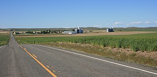
Horlick is an unincorporated community in Kittitas County, in the U.S. state of Washington. [1]

Kittitas County, Washington County in the United States

Kittitas County is a county located in the U.S. state of Washington. The population was 46,205 in a 2017 census estimate. Its county seat and largest city is Ellensburg. The county was created in November 1883 when it was carved out of Yakima County. Kittitas County comprises the Ellensburg, Washington, Micropolitan Statistical Area.

U.S. state constituent political entity of the United States

In the United States, a state is a constituent political entity, of which there are currently 50. Bound together in a political union, each state holds governmental jurisdiction over a separate and defined geographic territory and shares its sovereignty with the federal government. Due to this shared sovereignty, Americans are citizens both of the federal republic and of the state in which they reside. State citizenship and residency are flexible, and no government approval is required to move between states, except for persons restricted by certain types of court orders. Four states use the term commonwealth rather than state in their full official names.

Washington (state) State of the United States of America

Washington, officially the State of Washington, is a state in the Pacific Northwest region of the United States. Named for George Washington, the first president of the United States, the state was made out of the western part of the Washington Territory, which was ceded by Britain in 1846 in accordance with the Oregon Treaty in the settlement of the Oregon boundary dispute. It was admitted to the Union as the 42nd state in 1889. Olympia is the state capital; the state's largest city is Seattle. Washington is sometimes referred to as Washington State, to distinguish it from Washington, D.C., the capital of the United States, which is often shortened to Washington.

The community derives its name from Horlicks, a type of hot drink. [2]

Horlicks hot drink

Horlicks is a malted milk hot drink developed by founders James and William Horlick. It was first sold as "Horlick's Infant and Invalids Food," soon adding "aged and travelers" to their label. In the early 20th century it was sold as a powdered meal replacement drink mix.

Related Research Articles

Ely Township, Michigan Civil township in Michigan, United States

Ely Township is a civil township of Marquette County in the U.S. state of Michigan. The population was 2,010 at the 2000 census.

Wenatchee Mountains Mountain in Washington, USA

The Wenatchee Mountains are a range of mountains in central Washington State, United States of America. A major subrange of the Cascade Range, extending east 50 miles (80 km) from the Cascade crest, the Wenatchee Mountains separate the drainage basins of the Yakima River from the Wenatchee River. The crest of the range forms part of the boundary between Chelan and Kittitas Counties.

Cusseta, Alabama Town in Alabama, United States

Cusseta is a town in Chambers County, Alabama, United States. Situated between Opelika and Lanett, it was named for the ancient Creek Indian town of Cusseta. As of the 2010 census, its population was 123.

Glenmore, Ohio human settlement in Ohio, United States of America

Glenmore is an unincorporated community in eastern Willshire Township, Van Wert County, Ohio, United States. It lies at the intersection of the north-south Glenmore Road with the east-west Glenmore Road. Twentyseven Mile Creek, a subsidiary of the St. Marys River, runs on the western edge of Glenmore after rising a short distance to the south of the community. It is located 8½ miles southwest of Van Wert, the county seat of Van Wert County.

Withrow, Washington human settlement in Washington, United States of America

Withrow is an unincorporated community in Douglas County, Washington, United States.

Doyle is a hamlet in the town of Cheektowaga in Erie County, New York, United States. The southern half is part of the Kaisertown neighborhood, which includes portions of Cheektowaga, West Seneca, and South Buffalo.

Horlick Ice Stream

Horlick Ice Stream is a large ice stream on the featureless ice surface to the north of the main mass of the Horlick Mountains of Antarctica, draining west-southwestward, parallel to these mountains, to enter the lower portion of the Reedy Glacier. It was mapped by the U.S. Geological Survey from surveys and U.S. Navy air photos, 1960–64, and was named by the Advisory Committee on Antarctic Names in association with the Horlick Mountains.

Woodbine, Pennsylvania Unincorporated community in Pennsylvania, United States

Woodbine is an unincorporated community in York County, Pennsylvania, United States. Until 1978, this community was served by the Maryland and Pennsylvania Railroad at milepost 50.6.

Willoughby Run river in the United States of America

Willoughby Run is a tributary of Marsh Creek in Adams County, Pennsylvania in the United States.

Lake Holm, Washington CDP in Washington, United States

Lake Holm is a census-designated place (CDP) in King County, Washington, United States. The population was 3,221 at the 2010 census.

Galena is a ghost town in Lander County, Nevada near Battle Mountain.

Dartford is an unincorporated community in Spokane County, in the U.S. state of Washington.

Sandy Valley is an unincorporated community in Jefferson County, in the U.S. state of Pennsylvania.

Englewood is an unincorporated community in Lawrence County, in the U.S. state of South Dakota.

Maplecreek is an unincorporated community in Chelan County, in the U.S. state of Washington.

Moonax is an extinct town in Klickitat County, in the U.S. state of Washington.

Rockdale, Washington human settlement in Washington, United States of America

Rockdale is an extinct town in the northwest United States, in King County, Washington. The GNIS classifies it as a populated place.

Roza is an extinct town in Kittitas County, in the U.S. state of Washington. The GNIS classifies it as a populated place.

Winesap is an extinct town in Chelan County, in the U.S. state of Washington. The GNIS classifies it as a populated place.

Lillard Mill is an extinct town in Marshall County, in the U.S. state of Tennessee. The GNIS classifies it as a populated place.

References

Coordinates: 47°07′48″N120°47′05″W / 47.13000°N 120.78472°W / 47.13000; -120.78472

Geographic coordinate system Coordinate system

A geographic coordinate system is a coordinate system that enables every location on Earth to be specified by a set of numbers, letters or symbols. The coordinates are often chosen such that one of the numbers represents a vertical position and two or three of the numbers represent a horizontal position; alternatively, a geographic position may be expressed in a combined three-dimensional Cartesian vector. A common choice of coordinates is latitude, longitude and elevation. To specify a location on a plane requires a map projection.