
Barnegat Bay is a small brackish arm of the Atlantic Ocean, approximately 42 miles (67.2 km) long, along the coast of Ocean County, New Jersey in the United States. It is separated from the Atlantic by the long Barnegat Peninsula, as well as by the north end of Long Beach Island, popular segments of the Jersey Shore. The bay is fed by several small rivers, including the Toms River and Metedeconk River, which empty into the bay through small estuaries along its inner shore. The communities of Toms River, Silverton, and Forked River sit along the river estuaries on the bay.

The Mullica River is a 50.6-mile-long (81.4 km) river in southern New Jersey in the United States. The Mullica was once known as the Little Egg Harbor River.
The Bass River is a 4.7-mile-long (7.6 km) tributary of the Mullica River in southeastern New Jersey in the United States.

The Tuckahoe River is a 27.6-mile-long (44.4 km) blackwater river in southern New Jersey in the United States.
The Affair at Little Egg Harbor took place on October 15, 1778, in southern New Jersey, United States, during the American Revolution. The Loyalists killed nearly 50 Patriot men, bayonetting them as they slept. The massacre took place about one week after the Battle of Chestnut Neck, a British raid aimed at suppressing privateers who used the area as a base to harass and seize British ships and their cargoes.
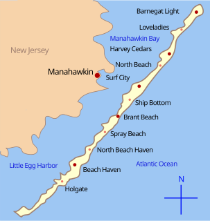
Little Egg Harbor is a brackish bay along the coast of southeast New Jersey. It was originally called Egg Harbor by the Dutch sailors because of the eggs found in nearby gull nests.
Landing Creek is an 11.2-mile-long (18.0 km) tributary of the Mullica River in southern New Jersey in the United States. The creek originates near Egg Harbor City and joins the Mullica River just below Lower Bank near Hog Islands. It is joined along its route by Union Creek, Indian Cabin Creek, Elliot's Creek, and Rubin's Run, respectively.
Nescochague Creek is a 6.4-mile-long (10.3 km) tributary of the Mullica River in southern New Jersey in the United States. The creek starts just northwest of Hammonton, arcs along the southern boundary of Wharton State Forest, and joins the Mullica River just above County Route 542.
Westecunk Creek is an 11.1-mile-long (17.9 km) tributary of Little Egg Harbor in southeastern New Jersey in the United States.
The South River is a 16.3-mile-long (26.2 km) tributary of the Great Egg Harbor River in Atlantic County, New Jersey, in the United States.
Stephen Creek is an 8.3-mile-long (13.4 km) tributary of the Great Egg Harbor River in southeast New Jersey in the United States.
English Creek is a 6.0-mile-long (9.7 km) tributary of the Great Egg Harbor River in southeast New Jersey in the United States.
Great Swamp Brook is a 9.1-mile-long (14.6 km) tributary of Nescochague Creek in the southern New Jersey Pine Barrens in the United States.
The Battle of Chestnut Neck was fought on October 6, 1778 in southern New Jersey during the American Revolutionary War, at Chestnut Neck, a settlement on the Little Egg Harbor River near the present-day city of Port Republic, New Jersey, which was used as a base by privateers. The British retrieved some supplies and destroyed others, as well as destroying some residences and other buildings.
The Little Egg Harbor Township School District is a comprehensive community public school district that serves students in pre-kindergarten through sixth grade from Little Egg Harbor Township School, in Ocean County, New Jersey, United States.
Little Beach is a barrier island along the coast of New Jersey. It is believed to be the last uninhabited barrier island left on the U.S. Atlantic coast. It is part of Galloway Township, in Atlantic County, New Jersey.
The Bass River Township School District is a community public school district that serves students in pre-kindergarten through sixth grade from Bass River Township, in Burlington County, New Jersey, United States.
The Atlantic Nuclear Power Plant was a proposed floating nuclear power plant located off the coast of New Jersey. It was proposed in the 1970s by the Public Service Electric and Gas Company. Two Westinghouse 1,150 MWe (net) pressurized water reactors were ordered in 1972, and another two Westinghouse 1,150 MWe (net) reactors were ordered in 1973. The four unit power plant proposal was canceled in 1978.
Great Egg Harbor Inlet is an inlet connecting Great Egg Harbor Bay with the Atlantic Ocean in New Jersey, forming a part of the boundary between Atlantic and Cape May Counties.


