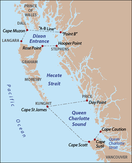
Queen Charlotte Sound is a sound of the Pacific Ocean in British Columbia, Canada, between Vancouver Island in the south and Haida Gwaii in the north. It merges with Hecate Strait in the north and Queen Charlotte Strait in the south.
Chatham Strait, or Shee ya xhaak in the Tlingit language, is a narrow passage of the Alexander Archipelago in the southeastern region of the U.S. state of Alaska. It separates Chichagof Island and Baranof Island to its west from Admiralty Island and Kuiu Island on its east.
Queen Charlotte Strait is a strait between Vancouver Island and the Mainland of British Columbia, Canada. It connects Queen Charlotte Sound with Johnstone Strait and Discovery Passage and via them to the Strait of Georgia and Puget Sound. It forms part of the Inside Passage from Washington to Alaska. The term Queen Charlotte Strait is also used to refer to the general region and its many communities, notably of the Kwakwaka'wakw peoples. Despite its name, Queen Charlotte Strait does not lie between Haida Gwaii and the mainland; that body of water is named Hecate Strait.
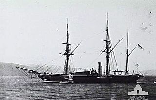
John Kendrick was an American sea captain, both during the American Revolutionary War and the exploration and maritime fur trading of the Pacific Northwest alongside his subordinate Robert Gray.

Masset, formerly Massett, is a village in Haida Gwaii in British Columbia, Canada. It is located on Masset Sound on the northern coast of Graham Island, the largest island in the archipelago, and is approximately 50 km (31 mi) west of mainland British Columbia. It is the western terminus of the Yellowhead Highway and is served by Masset Airport, with flights to Vancouver and Prince Rupert. During the maritime fur trade of the early 19th century, Masset was a key trading site. It was incorporated as a village municipality on May 11, 1961.
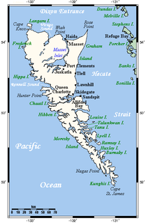
Moresby Island is a large island that forms part of the Haida Gwaii archipelago in British Columbia, Canada, located at 52.75°N 131.8333333°W.

Lyell Island, known also in the Haida language as Athlii Gwaii, is a large island in the Haida Gwaii archipelago on the North Coast of British Columbia, Canada. The island is a part of the Gwaii Haanas National Park Reserve and Haida Heritage Site.
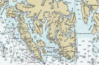
Long Island is an island in the Alexander Archipelago of southeastern Alaska, United States. It lies across the Kaigani Strait from the southern portion of Dall Island and west of the southern part of Prince of Wales Island. Directly to its north is Sukkwan Island. Long Island forms part of the western boundary of Cordova Bay, and has a land area of 116.136 km² and was unpopulated at the 2000 census.

Milbanke Sound is a sound on the coast of the Canadian province of British Columbia.

Naikoon Provincial Park is a provincial park on northeastern Graham Island in the Haida Gwaii archipelago, British Columbia, Canada. It is the ancestral home of the Gwak'rala'chala people, one of the many tribes that form the native group Haida. While it is a popular destination for adventurous campers, it is also very secluded, being over 16 km away from Masset.
Princess Royal was a British merchant ship that sailed on fur trading ventures in the late 1780s, and was captured at Nootka Sound by Esteban José Martínez of Spain during the Nootka Crisis of 1789. Called Princesa Real while under the Spanish Navy, the vessel was one of the important issues of negotiation during the first Nootka Convention and the difficulties in carrying out the agreements. The vessel also played an important role in both British and Spanish exploration of the Pacific Northwest and the Hawaiian Islands. In 1790, while under Spanish control, Princesa Real carried out the first detailed examination of the Strait of Juan de Fuca by non-indigenous peoples, finding, among other places, the San Juan Islands, Haro Strait, Esquimalt Harbour near present-day Victoria, British Columbia, and Admiralty Inlet.
Kunghit Island is an island in the Canadian province of British Columbia. It is the southernmost island in the Haida Gwaii archipelago, located to the south of Moresby Island. The southernmost point of Kunghit Island, called Cape St James, is used to delineated the boundary between Hecate Strait and Queen Charlotte Sound. The only habitation on Kunghit Island is Rose Harbour, on its north shore.

Masset Inlet is a large saltwater bay located in the heart of the lowland of northern Graham Island, the northernmost and largest island of the Haida Gwaii islands on the North Coast of British Columbia, Canada. It is fed by several rivers, the largest of which is the Yakoun River, and is connected to the open sea of the Dixon Entrance by the narrow Masset Sound and Masset Harbour, which opens onto McIntyre Bay. The communities of Port Clements and Sewall are located on the shores of Masset Inlet. The community of Juskatla is located on Juskatla Inlet, the largest of Masset Inlet's arms. There are several islands in the inlet, the largest of which is Kumdis Island, at the inlet's egress to Masset Sound and just north of Port Clements. Masset Inlet helps form the isthmus of the Naikoon Peninsula.
Cumshewa Inlet, also recorded or referred to in exploration logs as Cumchewas Harbour and Tooscondolth Sound, is a large inlet on the east coast of Moresby Island in the Haida Gwaii islands of the North Coast of British Columbia. The inlet was the site of various Haida villages, including Cumshewa, Tanu and Djí-gua. The name for the inlet was conferred in the days of the Maritime Fur Trade following a custom whereby captains named locations for the most important local chief, in this case Cumshewa, who figures in maritime fur trade vessel logs from 1787 onwards. In 1794 Cumshewa and his followers massacred the crew of the American trading vessel Resolution in Cumshewa Inlet.
Anthony Island is an island located in the southern part of Haida Gwaii, off the North Coast of British Columbia, Canada, to the west of Kunghit Island, the archipelago's southernmost. Anthony Island is noted for being the location of the ruins of SkungWai or SG̱ang Gwaay Llnaagay, commonly called Ninstints after the reigning mid-19th Century chief there. SG̱ang Gwaay Llnagaay was a major village of the Kunghit Haida people.

Skedans, also known variously as Koona, Q'una, Koona LLnaagay, K'uuna Llnagaay, Q!o'na Inaga'-I, Q:o'na, and Ḵ'uuna Llnagaay which are variants of its traditional name in the Haida language, is a village located at the head of Cumshewa Inlet in Haida Gwaii, North Coast of British Columbia, Canada. The name Skedans derived by the practice of captains of the maritime fur trade to name villages after their most prominent chiefs.
Campbell Island is an island in the Canadian province of British Columbia, located west of Denny Island and north of Hunter Island, near Milbanke Sound. The Inside Passage waterways of Lama Passage and Seaforth Channel meet at the northern end of Campbell Island.
Hotspring Island, originally named in English as Volcanic Island and known in the Haida language as G̱andll K'in Gwaayaay ("Hot-Water-Island"), is a small island near the southeast coast of Lyell Island in the Haida Gwaii archipelago of the North Coast of British Columbia, Canada. The island's names derive from a hot spring located on its southwestern end, the temperature of which has been measured at 162 °F (72 °C). The island is part of Gwaii Haanas National Park Reserve and Haida Heritage Site and is supervised by the Haida Gwaii Watchmen.
Burnaby Island is an island in Haida Gwaii off the north coast of British Columbia, Canada, located off the southeast coast of Moresby Island. It is part of the Gwaii Haanas National Park Reserve and Haida Heritage Site.
Darwin Sound is a sound in the Haida Gwaii islands of British Columbia, Canada. It is located between Moresby Island (W) and Lyell Island (E) and was named in 1878 by Canada's then-Chief Geographer George M. Dawson in honour of Charles Darwin, the eminent naturalist.