Houston Tap and Brazoria Railway

Last updated
Houston Tap and Brazoria Railway
LocaleSoutheast Texas
Dates of operation18561873
Predecessor Houston Tap Railroad
Successor Houston and Great Northern Railroad
Track gauge 4 ft 8 12 in (1,435 mm) standard gauge
Length50 miles (80 km)
Headquarters Houston

The Houston Tap and Brazoria Railway was chartered in September 1856 to extend southward from Houston to West Columbia in Brazoria County. The railroad's nicknames were the Columbia Tap and the Sugar Road. The railway absorbed track from an earlier short-lived line and reached West Columbia in 1860. After the American Civil War, the railroad ran into serious financial difficulties and was sold to the Houston and Great Northern Railroad. It was the only railroad that failed to repay money borrowed from the Special School Fund and the only railroad that could trace its title to the State of Texas. The line operated as part of the Missouri Pacific Railroad until 1980 when it was bought by the Union Pacific Railroad. In 2014, the part of the line closest to downtown Houston existed only as the Columbia Tap Rail-Trail, the portion of the line between Houston and Arcola was still in service and the section between Arcola and West Columbia was abandoned.

Houston Largest city in Texas

Houston is the most populous city in the U.S. state of Texas, fourth most populous city in the United States, as well as the sixth most populous in North America, with an estimated 2018 population of 2,325,502. Located in Southeast Texas near Galveston Bay and the Gulf of Mexico, it is the seat of Harris County and the principal city of the Greater Houston metropolitan area, which is the fifth most populous metropolitan statistical area in the United States and the second most populous in Texas after the Dallas-Fort Worth metroplex, with a population of 6,997,384 in 2018.

West Columbia, Texas City in Texas, United States

West Columbia is a city in Brazoria County in the U.S. state of Texas. The city is centered on the intersection of Texas Highways 35 & 36, 55 miles (89 km) southwest of downtown Houston. The population was 3,905 at the 2010 census.

Brazoria County, Texas County in the United States

Brazoria County is a county in the U.S. state of Texas. As of the 2010 census, the population of the county was 313,166. The county seat is Angleton.

Contents

History

1871 map showing the Houston Tap and Brazoria Railway in Texas, along with other railroads Asher & Adams' Texas (Eastern Half) 1871 UTA.jpg
1871 map showing the Houston Tap and Brazoria Railway in Texas, along with other railroads

In 1850 the Buffalo Bayou, Brazos and Colorado Railroad was chartered and in 1852 the company started construction. In 1853 the line reached Stafford and by January 1, 1856 the railroad ran from Harrisburg to Richmond. Worried that their city was being bypassed, the authorities in Houston desired to connect their city with Richmond by tapping into the B.B.B.&C. This was accomplished by building 7 miles (11 km) of the Houston Tap Railroad from Houston south to Pierce Junction. [1] Originally known as Peirce Junction, this location was named for Thomas Wentworth Peirce, a wealthy businessman who owned a plantation near Arcola. [2]

Stafford, Texas City in Texas, United States

Stafford is a city in the U.S. state of Texas, within the Houston–The Woodlands–Sugar Land metropolitan area. The city is mostly in Fort Bend County, with a small portion in Harris County. As of the 2010 census, Stafford's population was 17,693, up from 15,681 at the 2000 census. As of 2018, the population had risen to an estimated 21,265.

Harrisburg, Houston Houston

Harrisburg is a community that is now located within the city of Houston, Texas, United States.

Richmond, Texas City in Texas, United States

Richmond is a city in Fort Bend County, Texas, United States. It is the county seat, and is located within the Houston–The Woodlands–Sugar Land metropolitan area. As of the 2010 U.S. census, the city population was 11,679.

Incorporated on September 1, 1856, Houston Tap and Brazoria Railway was authorized to start in Houston and run south to West Columbia, then called Columbia. The charter also called for the line to continue from Columbia into Wharton County and to take over existing track from the Houston Tap Railroad. Construction on the Houston Tap started on April 7, 1856 and the completed line opened on October 21. The Houston Tap and Brazoria Railway purchased the Houston Tap from the city of Houston in June 1858 for $130,000 in stock and a loan of $42,000. The $42,000 loan was to be made once the railroad got its own loan from the state's Special School Fund. Houston was responsible for repayment of the loan. The line reached Sandy Point in 1859 and East Columbia in 1860. [3]

Wharton County, Texas County in the United States

Wharton County is a county located in the U.S. state of Texas. As of the 2010 census, its population was 41,280. Its county seat is Wharton. The county was named for brothers William Harris Wharton and John Austin Wharton.

Sandy Point, Texas City in Texas, United States

Sandy Point is a city on Farm to Market Road 521 (FM 521) in north central Brazoria County, Texas, United States. The small community is located near a state prison. In the 19th century, the settlement served nearby sugar cane and cotton plantations. Sandy Point's post office, school and railroad have disappeared, but there were two churches in the community in December 2013.

East Columbia, Texas Unincorporated community in Texas, United States

East Columbia is an Unincorporated community in Brazoria County, Texas, United States. It is located nine miles west from Angleton. It was one of the most important inland ports in Texas. The river port became a vital component in the plantation-based economy that developed along the Brazos River in the 19th century. The community was founded in 1824 by Josiah Hughes Bell. A native of South Carolina, Bell came to Texas with Stephen F. Austin’s Old 300 colony in 1821. Bell built a landing of log-lines docks and timbered stops on the Brazos River just below Varner’s Creek. Bell laid out the town and called it Marion. Bell sold the townsite to Walter C. White in 1827. By the mid-1800s the town had a population of 800. The arrival of the railroad in the area led to the decline of steamboat traffic which had an adverse effect on the town’s fortunes. Storms in 1900, 1909, and 1913 were destructive to the community. When oil was discovered in West Columbia in 1918, merchants abandoned East Columbia. By the 1970s the town's post office had already closed and its population had decreased substantially.

Present day right-of-way

Diamond cross where the BNSF Railway intersects the ex-Missouri Pacific in Arcola, Texas. The view is to the west along the BNSF from the grade crossing at FM 521. Arcola TX Diamond Cross on BNSF.JPG
Diamond cross where the BNSF Railway intersects the ex-Missouri Pacific in Arcola, Texas. The view is to the west along the BNSF from the grade crossing at FM 521.

A hike and bike trail in Houston is called the Columbia Tap Rail-Trail. It starts at Dowling and Walker Streets near downtown Houston and heads to the southeast. The trail turns southwest along Velasco Street and continues in the same direction under Interstate 45, past Texas Southern University, across Braes Bayou and ends at State Highway 288 (South Freeway) and Dixie Drive. [4] [5]

Texas Southern University university

Texas Southern University is a public historically black university (HBCU) in Houston, Texas. The university is one of the largest and most comprehensive HBCUs in the nation with over 10,000 students enrolled and over 100 academic programs. TSU is a leading producer of college degrees to African Americans and Hispanics in Texas and ranks fourth in the United States in doctoral and professional degrees conferred to African Americans. The university is a member school of the Thurgood Marshall College Fund and it is accredited by the Southern Association of Colleges and Schools.

Texas State Highway 288 highway in Texas

State Highway 288 or SH 288, is a north–south highway in the southeastern portion of the U.S. state of Texas, between I-45 in downtown Houston and Freeport, where it terminates on FM 1495. The route was originally designated by 1939, replacing the southern portion of SH 19.

The railroad terminus is located at 3131 Holcombe Blvd. a short distance south of the trail's end. From there, the line continues southwest across U.S. 90 Alternate before curving to the south-southwest so that it parallels Farm to Market Road 521 (FM 521) or Almeda Road. Without deviating from the same heading, the railroad tracks follow FM 521 under Interstate 610, through Central Southwest Houston, under State Highway Beltway 8, through Fresno and end just south of Arcola. At Arcola, the line connects with the east-west BNSF Railway. [6] The former right-of-way ran along FM 521 from Arcola south through Juliff, Sandy Point, Rosharon, Bonney, Chenango, and Anchor. At Anchor, the line curved to the southwest and then west, parallel with State Highway 35, before reaching West Columbia. [7]

Interstate 610 (I-610) is a freeway that forms a 38-mile-long (61 km) loop around the inner city sector of city of Houston, Texas. Interstate 610, colloquially known as The Loop, Loop 610, The Inner Loop, or just 610, traditionally marks the border between the inner city of Houston and its surrounding areas. It is the inner of the three Houston beltways, the other two being Beltway 8 and State Highway 99, of which various segments are under construction or planning.

Texas State Highway Beltway 8 highway in Texas

Beltway 8 (BW8), the Sam Houston Parkway, along with the Sam Houston Tollway, is an 88-mile (142 km) beltway around the city of Houston, Texas, United States, lying entirely within Harris County.

Fresno, Texas Census-designated place in Texas, United States

Fresno is an unincorporated community and census-designated place (CDP) in Fort Bend County, Texas, United States. The population was 19,069 at the 2010 census, up from 6,603 at the 2000 census.

Related Research Articles

Brazoria, Texas City in Texas, United States

Brazoria is a city in the U.S. state of Texas, in the Houston–The Woodlands–Sugar Land metropolitan area and Brazoria County. As of the 2010 U.S. Census, the city population was 3,019.

Genoa is an area in Houston, Texas, United States located about 15 miles (24 km) southeast of Downtown Houston; it was formerly a distinct unincorporated area in Harris County.

Northern Central Railway

The Northern Central Railway (NCRY) was a Class I Railroad connecting Baltimore, Maryland with Sunbury, Pennsylvania, along the Susquehanna River. Completed in 1858, the line came under the control of the Pennsylvania Railroad (PRR) in 1861, when the PRR acquired a controlling interest in the Northern Central's stock to compete with the rival Baltimore and Ohio Railroad (B&O). For eleven decades the Northern Central operated as a subsidiary of the PRR until much of its Maryland trackage was washed out by Hurricane Agnes in 1972; after which most of its operations ceased as the Penn Central declined to repair sections. It is now a fallen flag railway, having come under the control of the later Penn Central, Conrail, and then broken apart and disestablished. The southern part in Pennsylvania is now the York County Heritage Rail Trail which connects to a similar hike/bike trail in Northern Maryland down to Baltimore, named the Torrey C. Brown Rail Trail. Only the trackage around Baltimore remains in rail service.

Gulf, Colorado and Santa Fe Railway transport company

The Gulf, Colorado and Santa Fe Railway was a subsidiary of the Atchison, Topeka & Santa Fe Railway in eastern Texas and to Purcell, Oklahoma.

Rosharon, Texas Census-designated place in Texas, United States

Rosharon, also known as "Buttermilk Station," is an unincorporated community and census-designated place (CDP) in Brazoria County, Texas, United States, at the intersection of Farm to Market Road 521 and Farm to Market Road 1462. As of the 2010 census, it had a population of 1,152.

Washington State Route 170 highway in Washington

State Route 170 (SR 170) is a short, 3.68-mile (5.92 km) long state highway located within Grant County in the U.S. state of Washington. The highway begins at SR 17 west of Warden and travels east to end at Main Street in Warden. The current route of the highway was first established in 1967 as Secondary State Highway 11I (SSH 11I) and became SR 170 in 1970 after it was moved north of its previous route, which had been on maps since 1926, named SSH 11A in 1937 and renumbered to SR 170 in 1964. The old route ran from the Columbia River southwest of Basin City to SR 17 north of Mesa.

Juliff, Texas Unincorporated community in Texas, United States

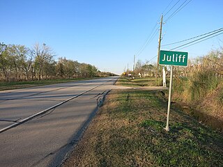
Juliff is an unincorporated community situated along Farm to Market Road 521 (FM 521) in eastern Fort Bend County, Texas, United States. The settlement was founded in the 1850s as a shipping point along the Brazos River and the railroad reached there in the same decade. The community received postal service in 1891, and except for a brief closure, retained it until the late 1950s. Starting in the 1930s, Juliff enjoyed a heyday as a place of raucous entertainment after local residents opened several taverns and dance halls. This era ended in the 1960s when the bars relocated to Houston. Sometime later, the railroad that ran alongside FM 521 was discontinued. In December 2013 the community was a collection of homes along the east side of FM 521.

Guy, Texas Unincorporated community in Texas, United States

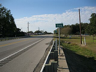
Guy is an unincorporated community in Fort Bend County, Texas, United States. It is located on Texas State Highway 36 (SH 36) about 16 miles (26 km) south of Rosenberg, Texas. A trucking company, a Shell Oil Company filling station, a post office, and several homes are located near the intersection of SH 36 and Farm to Market Road 1994 (FM 1994). The community was established in 1890 and was served by a railroad between 1918 and the 1980s.

Almeda, Houston human settlement in Houston, Texas, United States of America

Almeda is an area located along Texas State Highway 288 and the Missouri Pacific Railroad in Southwest Houston, Texas, United States that used to be a distinct unincorporated community in Harris County. Almeda is 11 miles (18 km) from Downtown Houston.

The Alabama Great Southern Railroad is a railroad in the U.S. states of Alabama, Georgia, Louisiana, Mississippi, and Tennessee. It is an operating subsidiary of the Norfolk Southern Corporation (NS), running southwest from Chattanooga to New Orleans through Birmingham and Meridian. The AGS also owns about a 30% interest in the Kansas City Southern-controlled Meridian-Shreveport Meridian Speedway.

English is an unincorporated community located at County Road 42 and Oyster Creek in northern Brazoria County, Texas, United States. English is north of the Ramsey Unit and 12 miles (19 km) northwest of Angleton. The Handbook of Texas states that the community may have been named after the family of an area resident named "Buck" English.

Stringfellow Unit

The A. M. "Mac" Stringfellow Unit is a Texas Department of Criminal Justice prison located in unincorporated Brazoria County, Texas, with a Rosharon, Texas postal address it is not inside the Rosharon census-designated place. The prison is located on Farm to Market Road 655, 4 miles (6.4 km) west of Farm to Market Road 521, and about 30 miles (48 km) south of Houston. The unit is co-located with the Ramsey Unit and the Terrell Unit on a 16,369-acre (6,624 ha) plot of land.

Fort Worth and Rio Grande Railway

The Fort Worth and Rio Grande Railway, chartered under the laws of Texas on June 1, 1885, was part of a plan conceived by Buckley Burton Paddock and other Fort Worth civic leaders to create a transcontinental route linking New York, Fort Worth, and the Pacific port of Topolobampo, which they believed would stimulate the growth and development of southwest Texas in general, and the economy of Fort Worth in particular.

The Houston and Texas Central Railway (H&TC), operated by the Houston and Texas Central Railway Company, was a railway system in Texas.

Howellville, Texas Unincorporated area in Texas, United States

Howellville or Howell is an unincorporated community in Harris County, Texas, United States, which has been absorbed by Greater Houston. The site is located at the intersection of Alief Clodine Road and Sugar Land Howell Road on the west side of Houston, approximately halfway between the original settlements of Clodine and Alief. There are no road signs identifying the place. The community began as a stop on a railroad line that no longer exists.

Duke, Texas Ghost town in Texas, United States

Duke is a ghost town in Fort Bend County, in the U.S. state of Texas. The former settlement's location was west of Arcola along the BNSF Railway near Houston Southwest Airport. In 2014 the town site was no longer accessible by public roads.

References

  1. Wharton, Clarence R. (2001). History of Fort Bend County. Austin, Tex.: Fort Bend Museum Association and Eakin Press. pp. 149–151.
  2. Hart, John Mason. "Handbook of Texas: THOMAS WENTWORTH PEIRCE". Texas State Historical Association . Retrieved January 12, 2014.
  3. Werner, George C. "Handbook of Texas: HOUSTON TAP AND BRAZORIA RAILWAY". Texas State Historical Association . Retrieved January 16, 2014.
  4. Google (January 11, 2014). "Columbia Tap Rail-Trail" (Map). Google Maps . Google. Retrieved January 11, 2014.
  5. "Trail of the Month January 2012: Columbia Tap Rail-Trail". Rails to Trails Conservancy. Retrieved January 12, 2014.
  6. Google (January 12, 2014). "Railroad along Almeda Road to Arcola" (Map). Google Maps . Google. Retrieved January 12, 2014.
  7. Google (January 12, 2014). "Railroad from Arcola to West Columbia" (Map). Google Maps . Google. Retrieved January 12, 2014.