| Hove | |
|---|---|
Hove Point | |
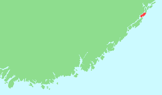
 Hove Location in Aust-Agder | |
| Coordinates | 58°26′33″N8°50′35″E / 58.44250°N 8.84306°E |

Hove is a largely beach area on the island of Tromøy in the municipality of Arendal in Aust-Agder county, Norway. [1] [2]
| Hove | |
|---|---|
Hove Point | |
| Hove Location in Aust-Agder | |
| Coordinates | 58°26′33″N8°50′35″E / 58.44250°N 8.84306°E |
Hove is a largely beach area on the island of Tromøy in the municipality of Arendal in Aust-Agder county, Norway. [1] [2]
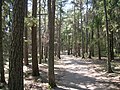
The Hove area lies on the southwest part of the island of Tromøy. The Skagerrak lies to the southeast, and to the northwest is Hove Bay (Hovekilen), a shallow protected marine area. [3] There is a strait to the southwest, separating Hove from the islands of Merdø and Gjessøya, and northeast of Hove is Spornes, with a beach that alternates between a sandy beach and a pebble beach depending on the wind and weather. [2] Tromøy Church and the Brekka farm stand further to the northeast. The entire area is characterized by a large moraine, [2] which creates the natural basis for pebble beaches, sandy beaches, and large areas of Aust-Agder's best arable land. The outer part of the Hove area is part of a moraine landscape area with the protected Hove Woods (Hoveskogen), containing windswept Scots pine. The inner part, facing Hove Bay, has extensive camping and beaches for swimming. [3] Hove Camping and the Hove Farm [4] are also located here. It is about 10 kilometers (6.2 mi) from Hove to the town of Arendal.
There are 17 registered burial mounds in Hove. The mounds date from the Bronze Age to the Viking Age. Hove was a part of a southwest Norwegian Viking kingdom around 800 AD. The name Hove suggests that it may have been the site of an old heathen hof. [5]
Hove Camp was taken over by the German occupation forces during the Second World War. Three radar installations were set up on Hove, a Regelbau R618 communications bunker, and an antiaircraft training center (the Feld Flakartillerie-schule (Nord) 50) from 1941 to 1944, probably along with four pieces of 88 mm antiaircraft artillery.
After the Second World War, Hove Camp was used by the Norwegian Armed Forces until 1962. In the 1970, the Workers' Communist Party conducted some of its annual summer camps at Hove Camp. For many years, until 2006, the state also used Hove Camp as an asylum reception center.
In 2003, the Friends of Hove (Hoves Venner) society was established, dedicated to helping preserve the area. Hove Camp is now administered by the Hove Operation and Development Company (Hove Drifts- og Utviklingsselskap AS), under 100% ownership of the municipality of Arendal, and it is being developed for cultural and tourism purposes. Starting in 2007, the camp was used for the Hove Festival, which was Norway's largest music festival that year.
The Norwegian reality television series 71° nord has used Hove several times for its broadcasts.
Hove has easily cultivated self-draining soil, and was therefore a favorable place for early agriculture. The Hove area originally belonged to the Hove Farm, which was one of the most important farms on Tromøy. The first known records of growing potatoes in Norway show that they were grown at the Hove Farm; on May 31, 1757 the customs clerk Niels Ålholm wrote in his garden diary that he had "observeret Potatoes at opkomme" (seen the potatoes come up). In 1773, 5,015 potatoes were planted at the farm. [6] Together with other farms located along Hove Bay, in the 19th century the Hove Farm was able to develop modern agriculture built around the sale of products in Arendal. The products were transported to the town by sea.
Hove has a shallow, sandy beach along the north side, facing Hove Bay; this was a popular swimming beach in the 1900s, especially for families with children. It is possible to take boat trips to Hove from Arendal in the summer, and ferry service operates from the town center. There is a campsite connected to the beach. The area is also a popular recreation area for hikers and other outdoor enthusiasts.


Hisøy is a former municipality in Aust-Agder county, Norway. The 10-square-kilometre (3.9 sq mi) municipality existed from 1881 until 1992 when it was merged into the municipality of Arendal. At the time of its dissolution, it was the smallest municipality in the whole county. The municipality encompassed the islands of Hisøya, Gjervoldsøy, Havsøya, Ærøya, Store Torungen, Lille Torungen, and several other small, unpopulated islands. The administrative centre was the village of Kolbjørnsvik on Hisøya island. Hisøy Church was the main church for the municipality, located in the village of His in the central part of Hisøya.

Austre Moland is a former municipality in Aust-Agder county, Norway. The municipality existed from 1838 until 1962 when it was merged into the neighboring municipality of Arendal. The administrative centre was at Brekka where the Austre Moland Church is located.

Eydehavn or Eydehamn is a village in the municipality of Arendal in Aust-Agder county, Norway. The village is located about 10 kilometres (6.2 mi) northeast of the centre of the town of Arendal, about 2 kilometres (1.2 mi) northeast of the village of Saltrød, about 2 kilometres (1.2 mi) south of the village of Strengereid, and just across the Tromøysundet strait from Kongshamn on the island of Tromøy. The village is named after Sam Eyde, the Norwegian engineer and industrialist. The local sports team is called IL Sørfjell. Eydehavn has about 1,100 residents as of 2015.

Tromøya or Tromøy is the largest island in Southern Norway. The 28.6-square-kilometre (11.0 sq mi) island is entirely located in the municipality of Arendal in Aust-Agder county, Norway. The island has about 5,300 residents which gives it a population density of about 185 inhabitants per square kilometre (480/sq mi). The island is located directly across the harbor from the town of Arendal. The highest point on the island is the 95-metre (312 ft) tall Vardåsen. The island is separated from the mainland to the north by the Tromøysundet strait and it is separated from the island of Hisøya to the southwest by the Galtesundet strait.

Ærøya is an unpopulated island in Arendal municipality in Aust-Agder county, Norway. The 0.12-square-kilometre (30-acre) island lies along the Skaggerak coast about 700 metres (2,300 ft) south of the larger island of Hisøya. The islands of Havsøya and Merdø lie to the northeast, the islands of Store Torungen and Lille Torungen lie to the southeast, and the island of Gjervoldsøy lies to the west.

Brattekleiv is a village in Arendal municipality in Aust-Agder county, Norway. The village is located along the Galtesundet strait on the southwestern shore of the island of Tromøy. The village lies about 1 kilometre (0.62 mi) southwest of the town of Arendal which is located across the strait. The smaller industrial village of Pusnes lies immediately north of Brattekleiv, the small village of Revesand lies just south of the village, and the village of Færvik lies a short distance to the east.

Færvik is a village in Arendal municipality in Aust-Agder county, Norway. The village is located on the southwestern part of the island of Tromøy. It sits east of Pusnes and Brattekleiv and north of Revesand. Færvik Church is located just southwest of the village. Færvik was the administrative centre of the old Tromøy municipality from 1878 until 1992.

Pusnes is a village in Arendal municipality in Aust-Agder county, Norway. The village is located on the southwestern edge of the island of Tromøy, just across the strait from the town of Arendal. There is a ferry that regularly crosses the strait from Pusnes to Arendal. Pusnes is primarily an industrial area.
Revesand is a village in Arendal municipality in Aust-Agder county, Norway. The village is located at the southern coast of the island of Tromøy, about 1 kilometre (0.62 mi) north of the island outport of Merdø.

Saltrød is a village in Arendal municipality in Aust-Agder county, Norway. The village is located along the Norwegian County Road 410, about 5 kilometres (3.1 mi) northeast of the town of Arendal and about 2 kilometres (1.2 mi) southwest of the village of Eydehavn. The village lies along the Tromøysundet strait, looking across the water towards the island of Tromøy. Stokken Church is located in Saltrød.
Åmdalsøyra or Omdalsøyra is a village in Arendal municipality in Aust-Agder county, Norway. The village is located along the Tromøysundet strait on the northern shore of the island of Tromøy. The village of Kongshavn lies just to the southwest of Åmdalsøyra and the village of Eydehavn lies just across the strait on the mainland.
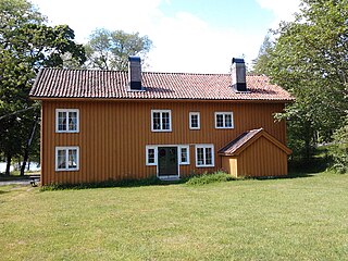
Hove Farm is an original undivided farm (matrikkelgård) on the southwest part of the island of Tromøy in the municipality of Arendal in Aust-Agder county, Norway. The farm is located on a headland, with the sea behind it to the southeast and facing Hove Bay (Hovekilen) to the northwest. Hove Bay is a protected marine area, accessible only to small vessels. The islands of Merdø and Gjesøya lies closest to Hove. Until 1942, Hove Farm had a single registration number and a single owner. The farm was purchased by the state in 1942, and was then used by the German occupation forces during the Second World War. Today the farm belongs to the municipality of Arendal.
Flostaøya is an island in Arendal municipality in Aust-Agder county, Norway. The 7.9-square-kilometre (3.1 sq mi) island lies along the Skaggerak coast between the islands of Tromøy to the southwest and Tverrdalsøya to the northeast. The island lies about 11 kilometres (6.8 mi) northeast of the town of Arendal. Some of the larger villages on the island include Arnevik, Narestø, and Kalvøysund. The island has a bridge connection to the mainland at the southwest corner of the island and there is a bridge connection to Kilsund on the neighboring island of Tverrdalsøya at the north end.

Store Torungen Lighthouse is a coastal lighthouse on the island of Store Torungen in the municipality of Arendal in Aust-Agder county, Norway. This lighthouse, together with the nearby Lille Torungen Lighthouse, mark the entrance from the Skaggerak through the outlying islands to the mainland town of Arendal. Both lighthouses were built in 1844 with the same specifications, making "twin" lighthouses marking the way to Arendal. The two lighthouses were put on the coat-of-arms for the local municipality of Hisøy in which the lighthouses were located. Over time, both lighthouses were replaced, and the only one still standing is the Lille Torungen Lighthouse, although it is no longer in use. The site of the Store Torungen Lighthouse is accessible only by boat. The island and site is open to the public, the tower is open daily during the summers, and the lighthouse keepers house is available to rent for overnight accommodations.

Lille Torungen Lighthouse is a coastal lighthouse on the island of Lille Torungen in the municipality of Arendal in Aust-Agder county, Norway. This lighthouse, together with the nearby Store Torungen Lighthouse, mark the entrance from the Skaggerak through the outlying islands to the mainland town of Arendal. Both lighthouses were built in 1844 with the same specifications, making "twin" lighthouses marking the way to Arendal. The two lighthouses were put on the coat-of-arms for the local municipality of Hisøy in which the lighthouses were located. Over time, both lighthouses were replaced, and the only one still standing is the Lille Torungen Lighthouse, although it is no longer in use. The site of the Lille Torungen Lighthouse is accessible only by boat. The island and site is open to the public, but the buildings are not.