
Reedham is a village and civil parish in the English county of Norfolk and within The Broads. It is on the north bank of the River Yare, some 12 miles (19 km) east of the city of Norwich, 7.5 mi (12.1 km) south-west of the town of Great Yarmouth and the same distance north-west of the Suffolk town of Lowestoft.

The Halvergate Marshes are an area of grazing marsh in the east of the English county of Norfolk. They form part of the area of The Broads and lie between the River Bure and the River Yare, bordering Breydon Water on the east. The marshes cover an area of around 2,642 hectares An area of 1,432.7-hectare (3,540-acre) is a biological Site of Special Scientific Interest. Some areas are also in the Breydon Water Local Nature Reserve, the Broadland and Breydon Water Ramsar sites, The Broads Special Area of Conservation, and The Broads and Breydon Water Special Protection Areas.

Halvergate is a village and civil parish in the English county of Norfolk, north of Reedham, between the Rivers Bure and Yare, within The Broads. To the east of the village is the hamlet of Wickhampton and the Halvergate Marshes, an area of drainage marsh which was the site of the first Environmentally Sensitive Area in the United Kingdom in 1987.
The River Ant is a tributary river of the River Bure in the county of Norfolk, England. It is 27 kilometres (17 mi) long, and has an overall drop of 27 metres from source to mouth. It is said that the Ant was formerly known as the River Smale and that this is the origin of the name of the village of Smallburgh.

Broadland is a local government district in Norfolk, England, named after the Norfolk Broads. The population of the local authority district taken at the 2011 Census was 124,646. Its council is based in Thorpe St Andrew, which is a suburb of the city of Norwich.
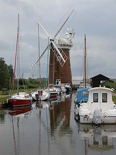
Horsey Windpump is a windpump or drainage windmill in the care of the National Trust in the village of Horsey, on The Broads near Great Yarmouth, Norfolk, England. The structure is a grade II* listed building.

Ashby with Oby is a civil parish in the English county of Norfolk, which is located some 5 kilometres (3 mi) north of Acle and 15 kilometres (9 mi) north-west of Great Yarmouth. The parish largely comprises scattered farms, and is named for the tiny settlements of Ashby and Oby.

Haddiscoe is a village and civil parish in the South Norfolk district of Norfolk, England, about 16 miles (26 km) southeast of Norwich. The parish is on the county boundary with Suffolk, about 7 miles (11 km) west-northwest of Lowestoft. The parish includes the hamlet of Thorpe-next-Haddiscoe, about 1 mile (1.6 km) north of Haddiscoe village.
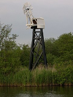
Mutton's Mill is a windpump located on the Halvergate Marshes in the detached parish of Freethorpe within The Broads in the English county of Norfolk. The mill is a Grade II* listed building and is 1 mile (1.6 km) east of the village of Halvergate and 2 miles (3.2 km) north-west of Berney Arms. It lies close to the route of the Weavers' Way long-distance footpath.

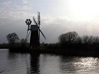
Boardman’s Drainage Windmill is located at How Hill in the English county of Norfolk It is on the east bank of the River Ant close to the large Edwardian building houses the Norfolk Broads Study Centre. The Drainage mill is 1½ miles west of the village of Ludham. The structure is a grade II* listed building.

Clayrack Drainage Windmill is located at How Hill in the English county of Norfolk. It is on the east bank of the River Ant close to How Hill, a large Edwardian building which houses the Norfolk Broads Study Centre. The Drainage mill is 1¾ miles west of the village of Ludham.
Horsey is a village and civil parish in the English county of Norfolk within The Broads national park. It covers an area of 8.49 km2 (3.28 sq mi) and had a population of 99 in 40 households at the 2001 census. At the 2011 Census the population remained less than 100 and was included in the civil parish of Sea Palling. For the purposes of local government, it falls within the district of North Norfolk.

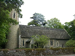
Starston Wind Pump is a hollow post mill for pumping water, situated west of the village of Starston in Norfolk, England. The Pump is 330 yards away from the parish church of Saint Margaret in Mill Field. The windpump is a Grade II listed building and a scheduled ancient monument. After some years on the Heritage at Risk Register because of its poor condition, it was restored in 2010.

Edward Boardman (1833–1910) was a Norwich born architect. He succeeded John Brown as the most successful Norwich architect in the second half of the 19th century. His work included both civic and ecclesiastical buildings, in addition to private commissions. Together, with his rival, George Skipper, he produced many notable buildings with several standing to this day (2013).
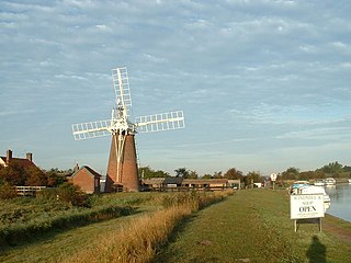
Stracey Arms Windpump is a windpump located at Tunstall in the civil parish of Halvergate, Norfolk, England. It is a grade II* listed building.
Hobb's Mill, also known as Hobbs Drainage Mill, is an open trestle windpump which stands by the side of the River Bure in Horning, North Norfolk, England, and is a Grade II* listed structure.

How Hill House is a large Edwardian house in How Hill, an area of Ludham parish, Norfolk, England. The house overlooks the River Ant and is within the Broads National Park. The house was designed by the English architect Edward Boardman in 1903, who intended it to be his family's country retreat. The Boardman family owned the house until 1966 before its sale to Norfolk County Council. Years later it was sold to Norwich Union who eventually gifted the house to the How Hill Trust, an environmental education charity. The house is a Grade II listed building.

The Acle Straight, also known as the Acle New Road is a major road between Acle and Great Yarmouth in Norfolk. It is part of the A47 trunk road.

Ant Broads and Marshes is a 745.3-hectare (1,842-acre) biological Site of Special Scientific Interest north-east of Norwich in Norfolk. Most of it is a Nature Conservation Review site, Grade 1, and it is part of the Broadland Ramsar and Special Protection Area, and The Broads Special Area of Conservation. Part of it is the Barton Broad nature reserve, which is managed by the Norfolk Wildlife Trust, and two areas are National Nature Reserves.

Upper Thurne Broads and Marshes is a 1,185.9-hectare (2,930-acre) biological Site of Special Scientific Interest north of Great Yarmouth in Norfolk. Part of it is a Nature Conservation Review site, Grade I, and it is in the Norfolk Coast Area of Outstanding Natural Beauty. It is part of the Broadland Ramsar site and Special Protection Area, and The Broads Special Area of Conservation. Two areas, Hickling Broad and Martham Broad, are national nature reserves managed by the Norfolk Wildlife Trust.

