
North Cascades National Park is an American national park in the state of Washington. At more than 500,000 acres (200,000 ha), it is the largest of the three National Park Service units that comprise the North Cascades National Park Complex. North Cascades National Park consists of a northern and southern section, bisected by the Skagit River that flows through the reservoirs of Ross Lake National Recreation Area. Lake Chelan National Recreation Area lies on the southern border of the south unit of the park. In addition to the two national recreation areas, other protected lands including several national forests and wilderness areas, as well as Canadian provincial parks in British Columbia, nearly surround the park. North Cascades National Park features the rugged mountain peaks of the North Cascades Range, the most expansive glacial system in the contiguous United States, the headwaters of numerous waterways, and vast forests with the highest degree of flora biodiversity of any American national park.

Chelan County is a county in the U.S. state of Washington. As of the 2020 census, its population was 79,074. The county seat and largest city is Wenatchee. The county was created out of Okanogan and Kittitas Counties on March 13, 1899. It derives its name from a Chelan Indian word meaning "deep water," likely a reference to 55-mile (89 km)-long Lake Chelan, which reaches a maximum depth of 1,486 feet (453 m).

The Okanogan National Forest is a U.S. National Forest located in Okanogan County in north-central Washington, United States.

Lake Chelan is a narrow, 50.5 mi (81.3 km) long lake in Chelan County, north-central Washington state, U.S. It is an overdeepened lake and resembles a fjord, with an average width of 1.3 mi (2.1 km). Near its upper end, the lake surface lies more than 6,600 ft (2,000 m) below peaks less than 3 mi (4.8 km) away. Before 1927, Lake Chelan was the largest natural lake in the state in terms of both surface area and water volume. Upon the completion of Lake Chelan Dam in 1927, the elevation of the lake was increased by 21 ft (6.4 m) to its present maximum-capacity elevation of 1,100 ft (340 m).
Stehekin is a small unincorporated community in Chelan County, Washington. The name "Stehekin" comes from a word in the Salishan language that means "the way through". Stehekin has about 75 permanent residents, although its population swells during the summer with vacationers and seasonal workers.

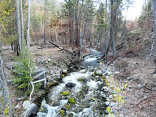
The Stehekin River is a river located in Washington state in the Pacific Northwest of the United States. It is the main river flowing into Lake Chelan. Miners arrived in Stehekin River Valley in the late 19th century. They were followed by homesteaders in the early 20th century. Today, the Stehekin River Valley is still a remote area that can only be reached by way of a 55-mile boat ride up Lake Chelan.

Lake Chelan National Recreation Area is a national recreation area located about 35 miles (56 km) south of the Canada–US border in Chelan County, Washington. It encompasses an area of 61,958 acres (25,074 ha) including the northern end of Lake Chelan and the surrounding area of the Stehekin Valley and the Stehekin River. The area is managed by the U.S. National Park Service as part of the North Cascades National Park Service Complex.
Holden Village is a year-round Lutheran Christian center in the North Cascade mountains of the U.S. state of Washington. Formerly the site of one of the largest copper mines in the United States, the Holden mine, Holden is accessible only by the Lake Chelan passenger ferry, the Lady of the Lake, or by hiking in through the Cascade Mountains. Holden Village is the largest retreat center in the nation operating under a special use permit from the United States Department of Agriculture - Forest Service.

The Purple Point-Stehekin Ranger Station House is a National Park Service ranger residence located in the Lake Chelan National Recreation Area of northern Washington. The building was built at Purple Point above Lake Chelan in the small, unincorporated community of Stehekin, Washington. It was originally constructed by the United States Forest Service to serve as the residence for the Stehekin District ranger. The Forest Service later converted it into a summer guard station. The building was transferred to the National Park Service in 1968 when the Lake Chelan National Recreation Area was established. The Purple Point-Stehekin Ranger Station House is listed on the National Register of Historic Places.

The Buckner Homestead Historic District, near Stehekin, Washington in Lake Chelan National Recreation Area incorporates a group of structures relating to the theme of early settlement in the Lake Chelan area. Representing a time period of over six decades, from 1889 to the 1950s, the district comprises 15 buildings, landscape structures and ruins, and over 50 acres (200,000 m2) of land planted in orchard and criss-crossed by hand-dug irrigation ditches. The oldest building on the farm is a cabin built in 1889. The Buckner family bought the farm in 1910 and remained there until 1970, when the property was sold to the National Park Service. The Buckner Cabin was listed on the National Register of Historic Places in 1974. The rest of the Buckner farm became a historic district in 1989. Today, the National Park Service maintains the Buckner homestead and farm as an interpretive center to give visitors a glimpse at pioneer farm life in the Stehekin Valley.

The Golden West Lodge Historic District includes the Golden West Lodge and six log cabins around it in Stehekin, Washington. Built in 1926, the lodge used salvaged portions of the Field Hotel, demolished the same year when the level of Lake Chelan was raised. Located in Lake Chelan National Recreation Area, the lodge was rehabilitated to function as the National Park Service Stehekin District Headquarters and Visitor Center in 2002.

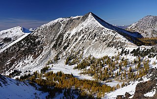
Buckner Mountain is a tall peak in the North Cascades of Washington state and in the Stephen Mather Wilderness of North Cascades National Park. At 9,114 feet (2,778 m) in elevation it is the highest in Skagit County and one of about ten of Washington's non-volcanic peaks above 9,000 feet high. It is ranked as the 14th highest peak in the state, and the third highest peak in North Cascades National Park.
Twenty-Five Mile Creek State Park is a public recreation area on the western side of Lake Chelan, 15 miles (24 km) northwest of the city of Chelan in Chelan County, Washington. The 232-acre (94 ha) state park was a private resort that came into state ownership in 1972. It was operated under lease to various concessionaires until the state took over staffing in 1988. The park offers camping, a marina, fishing, waterskiing, bird watching, and mountain biking.

Pramila Jayapal is an American politician serving as the U.S. representative from Washington's 7th congressional district since 2017. A member of the Democratic Party, she represents most of Seattle, as well as some suburban areas of King County. Jayapal represented the 37th legislative district in the Washington State Senate from 2015 to 2017. She is the first Indian-American woman to serve in the U.S. House of Representatives. The district's first female member of Congress, she is also the first Asian American to represent Washington at the federal level.
The 2016 United States House of Representatives elections in Washington were held on November 8, 2016, to elect the 10 U.S. representatives from the state of Washington, one from each of the state's 10 congressional districts. The elections coincided with the 2016 U.S. presidential election, as well as other elections to the House of Representatives, elections to the United States Senate and various state and local elections. The primaries were held on August 2.

Lucerne is an unincorporated community in Chelan County, Washington, United States. Lucerne is assigned the ZIP code 98816.

Rainbow Falls is a waterfall on Rainbow Creek in the U.S. state of Washington. The waterfall is located inside the Lake Chelan National Recreation Area in the North Cascades National Park, and is near Stehekin. The falls drops 392 feet (119.5 m) in two tiers. The uppermost tier falls 312 feet (95.1 m) to a basin.
Courtney Peak is an 8,392-foot (2,558-metre) mountain summit located in the Methow Mountains, a sub-range of the North Cascades in Washington state. Situated on Sawtooth Ridge, Courtney Peak is part of the Lake Chelan-Sawtooth Wilderness, a protected area within the Okanogan–Wenatchee National Forest. Courtney Peak ranks 78th on Washington's highest 100 peaks, and 81st on the "Bulger List". The nearest higher peak is Star Peak, 0.83 miles (1.34 km) to the southeast. Precipitation runoff on the west side of the mountain drains into nearby Lake Chelan via Fish Creek, whereas the north side of the mountain drains into Oval Creek, and the east side drains into Buttermilk Creek, both of which are tributaries of the Twisp River. The mountain's name was officially adopted in 1985 to remember James (Ray) Courtney (1920-1982), a commercial packer and lifelong resident of Stehekin. The immediate vicinity of this peak was a favorite destination for his guided outings. Ray Courtney died in an accident while leading such a pack trip with 29 hikers when the horse he was riding lost its footing and fell down a gully.

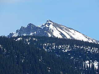
McGregor Mountain is an 8,122-foot (2,476-metre) elevation massif located in the Stehekin Valley of the North Cascades, in Chelan County of Washington state. McGregor Mountain is situated northwest of Lake Chelan in the northern Methow Mountains, on the shared border of North Cascades National Park and Lake Chelan National Recreation Area. The closest community is Stehekin, and the nearest higher neighbor is Goode Mountain, 7.3 miles (11.7 km) to the northwest. Precipitation runoff from the mountain drains into tributaries of the Stehekin River. Topographic relief is significant since the southern aspect of the mountain rises 6,600 feet above this river in approximately two miles. The famous Pacific Crest Trail traverses the western base of this mountain, and the strenuous 7.7-mile (12.4 km) McGregor Mountain Trail gains 6,400 feet of elevation to take hikers within a half-mile of the summit. Reaching the summit requires exposed scrambling the final 1,100 feet, and an ice axe is needed if the trail remains covered by snowpack. The summit was the site of an old fire lookout cabin from 1923 until 1955, but now has a radio repeater for the National Park Service. The views from the top include Glacier Peak, Black Peak, Corteo Peak, Frisco Mountain, Tupshin Peak, Dome Peak, Glory Mountain, and many others. This mountain was named for Billy McGregor, a Stehekin Valley resident who had a cabin and homestead at the base of this mountain during the 1890s. In May 1901, Billy disappeared overnight from a boat docked in Lake Chelan, and was never seen or heard from again.
Hock Mountain is a 7,750-foot-elevation summit located in the Methow Mountains, a subset of the North Cascades in Washington state. It is situated on the triple-shared boundary of North Cascades National Park, Lake Chelan-Sawtooth Wilderness, and Lake Chelan National Recreation Area, as well as the shared border between Chelan County and Okanogan County. Additionally, it lies one mile southwest of Twisp Mountain, and 2.24 miles (3.60 km) due south of Stiletto Peak, the nearest higher neighbor. The north face is steep, granitic rock, but the west slope is more moderate, allowing a scramble ascent. Precipitation runoff from the north and west sides of Hock drains to the Stehekin River via Bridge Creek, whereas the south and east sides of the mountain drain into the South Fork Twisp River.
