
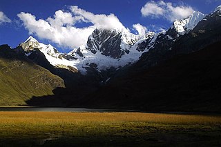
The Huallanca mountain range (possibly from Quechua, wallanka mountain range; a cactus plant ; also called Chaupi Janca or Shicra Shicra lies in the Andes of Peru. It is located in the Ancash Region, Bolognesi Province. The Huallanca mountain range is a small range southeast of the Cordillera Blanca and north of the Huayhuash mountain range extending between 9°52' and 10°03'S and 76°58' and 77°04'W for about 19 km in a northeasterly direction.
Lake Niancocha is a lake in Peru, in the Ancash Region, Bolognesi Province, Huallanca District. Niancocha is northeast of the Huayhuash mountain range, south of the lake Condorcocha and northwest of Chonta mountain.

Auxilio is a mountain in the west of the Huayhuash mountain range in the Andes of Peru, about 5,560 metres (18,241 ft) high. It is located in the Ancash Region, Bolognesi Province, Pacllon District, and in the Lima Region, Cajatambo Province, Copa District. Auxilio lies on the sub-range west of Yerupaja, south of Auxilio Lake and southwest of the mountain Huacrish.
Rajucollota, Suerococha, named after the nearby lake, or Diablo Mudo is a mountain in the west of the Huayhuash mountain range in the Andes of Peru, about 5,427 metres (17,805 ft) high. It is located in the Ancash Region, Bolognesi Province, Pacllon District, and in the Lima Region, Cajatambo Province, Copa District. Rajucollota lies on a sub-range west of Yerupaja, west of the mountain Huacrish, northwest of the mountain Auxilio and north of the lake Suerococha.

Inti Watana, Intiwatana or Pumaqucha is an archaeological site in Peru. It is located in the Ayacucho Region, Vilcas Huamán Province, Vischongo District, at the lake Pumaqucha.

Hatun Pastu is a mountain in the Andes of Peru, about 5,170 metres (16,962 ft) high. It is located in the Puno Region, Lampa Province, on the border of the districts Palca and Paratía, southeast of the mountain Qillqa and north of Waykira.
Millpu is a mountain in the Andes of Peru, about 5,300 metres (17,388 ft) high. It is situated south of the Huayhuash mountain range. Its main peak and the northern peak are located in the Lima Region, Cajatambo Province, Cajatambo District, south of Puka Qaqa and a lake named Quyllurqucha. The southern peak of Millpu lies at 10°29′5″S76°51′9″W on the border with the Oyon Province, Oyon District.

Jullutahuarco is a mountain in the west of the Huayhuash mountain range in the Andes of Peru, about 5,400 metres (17,717 ft) high. It is located in the Lima Region, Cajatambo Province, Copa District. Jullutahuarco lies on the sub-range west of Yerupaja, south of Rajucollota, Huacrish and Auxilio. It is situated north of the Huayllapa River.
Suerococha is a mountain in the west of the Huayhuash mountain range in the Andes of Peru, about 5,100 metres (16,732 ft) high, and the name of a small lake near the mountain. The mountain is located in the Ancash Region, Bolognesi Province, Pacllon District. Suyruqucha lies on a sub-range west of Yerupaja, northwest of Huacrish and Auxilio and northeast of Rajucollota.
Suerococha is a mountain in the south of the Huayhuash mountain range in the Andes of Peru, about 5,000 metres (16,404 ft) high, and the name of a small lake near the mountain. The mountain is located in the Lima Region, Cajatambo Province, Cajatambo District. It lies east of Cuyoc.
Yanacushman is a mountain in the Huayhuash mountain range in the Andes of Peru, about 4,800 m (15,748 ft) high. It is located in the Lima Region, Cajatambo Province, Cajatambo District. Yanacushman lies on the southern sub-range west of the main range, northwest of Julcán and Huacshash. It is situated between the Huayllapa valley and the Pumarinri valley.
Gasha is a 4,880-metre-high (16,010 ft) mountain in the northern part of the Huayhuash mountain range in the Andes of Peru. It is located in the Ancash Region, Bolognesi Province, Pacllón District, and in the Huánuco Region, Lauricocha Province, Queropalca District. Gasha lies northwest of Mitococha and north of Paria.
Machu Qichqa is a mountain in the Huancavelica Region in Peru, about 4,800 metres (15,748 ft) high. It is situated in the Huaytará Province, Pilpichaca District. Machu Qichqa lies southwest of Yawarqucha and northwest of Wakan Q'allay.
Tankan or Ruq'a Qaqa, qaqa rock, Hispanicized Rucagaga) is a 5,162-metre-high (16,936 ft) mountain in the northern part of the Wallanka mountain range in the Andes of Peru. It is located in the Ancash Region, Bolognesi Province, in the districts of Aquia and Huallanca.
Parqu is a mountain west of the Paryaqaqa or Waruchiri mountain range in the Andes of Peru, about 4,800 m (15,748 ft) high. It is situated in the Lima Region, Huarochirí Province, Quinti District. Parqu lies between the Qarwapampa valley in the west and the Mankaqutu valley in the east, west of the lake named Suyuqqucha.
Mituraju is a 5,750-metre-high (18,865 ft) mountain in the north of the Huayhuash mountain range in the Andes of Peru. It is located in the Ancash Region, Bolognesi Province, Pacllón District, and in the Huánuco Region, Lauricocha Province, Queropalca District. Mituraju lies southeast of Rondoy and southwest of Lake Mitucocha.
Alcay is a 5,300-metre-high (17,388 ft) mountain in the north of the Huayhuash mountain range in the Andes of Peru. It is located in the Huánuco Region, Lauricocha Province, Queropalca District. Alcay lies northwest of a lake named Carhuacocha, east of Mituraju and southeast of Rondoy. The little lake northeast of the mountain is Alcaycocha.
Tancancocha is a mountain in the north of the Huallanca mountain range in the Andes of Peru at a small lake of that name. The mountain reaches an altitude of approximately 5,200 m (17,100 ft). It is located in the Ancash Region, Bolognesi Province, in the districts of Aquia and Huallanca.
Muchka is a mountain in the Cordillera Central in the Andes of Peru which reaches a height of approximately 4,600 metres (15,092 ft). It is located in the Lima Region, Yauyos Province, on the border of the districts of Alis and Vitis, northwest of Alis.
Millwa Qaqa is a mountain in the Andes of Peru which reaches a height of approximately 4,600 m (15,100 ft). It is located in the Ancash Region, Bolognesi Province, Huallanca District.


