
Huayna Capac was the third Sapa Inca of Tawantinsuyu, the Inca Empire. He was the son of and successor to Túpac Inca Yupanqui., the sixth Sapa Inca of the Hanan dynasty, and eleventh of the Inca civilization. He was born in Tumipampa and tutored to become Sapa Inca from a young age.

Huayna Picchu, Quechua: Wayna Pikchu, is a mountain in Peru around which the Urubamba River bends. It is located in the Cusco Region, Urubamba Province, Machupicchu District. It rises over Machu Picchu, the so-called Lost City of the Incas. The Incas built a trail up the side of the Huayna Picchu and constructed temples and terraces at its top. The peak of Huayna Picchu is 2,693 metres (8,835 ft) above sea level, or about 260 metres (850 ft) higher than Machu Picchu.

Palcaraju is a mountain in the Cordillera Blanca mountain range in the region of Ancash within the Peruvian Andes. It has an elevation of 6,274 metres (20,584 ft) on its main summit.
Ayapata District is one of ten districts of the province Carabaya in Peru.
Ullachiya District is one of ten districts of the province Carabaya in Peru.
Wayna Potosí is a mountain in the Andes of Bolivia, about 4,969 metres (16,302 ft) high. It is located in the Oruro Department, Sajama Province, Turku Municipality, Turku Canton, northwest of Turku (Turco). The Turku River originates near the mountain. It is a left tributary of the Lauca River.
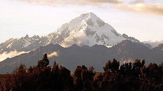
Veronica, also called Huacrahuilki, Huacay Huilcay, Wayna Willka,Waqaywillka, Urubamba, or Padre Eterno, is a 5,893 m (19,334 ft) mountain in the Urubamba mountain range in the Andes of Peru. It is located in the Cusco Region, La Convención Province, Huayopata District, and in the Urubamba Province, Ollantaytambo District northwest of the town of Ollantaytambo.
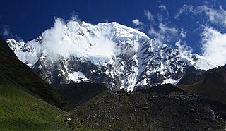
The Vilcabambamountain range is located in the region of Cusco, Peru, in the provinces of Anta, La Convención and Urubamba. It extends between 13°10' and 13°27'S. and 72°30' and 73°15'W for about 85 km. Its highest peak is Salcantay, which is 6,271 m (20,574 ft) above sea level.
The Cordillera Carabaya lies in the Andes of Peru. It extends between 14°00' and 14°22'S and 69°38' and 70°19'W for about 75 km. It is located in the Puno Region, Carabaya Province, between the Vilcanota mountain range in the north-west and the Apolobamba mountain range in the south-east, north and north-east of Macusani.
Allincapac,Allin Ccapac or Allin Japac is a mountain in the Andes of Peru. It is the highest peak of the Carabaya mountain range, rising up to 5,805 metres (19,045 ft). Allincapac is located in the Puno Region, Carabaya Province, Macusani District, south of Huaynaccapac, northeast of Chichicapac and north of Lake Chaupicocha.

Mawk'allaqta, also Mawk'a Llaqta is an archaeological site in Peru. It is located in the Cusco Region, Espinar Province, on the border of the districts Coporaque and Suykutambo. Mawk'allaqta is situated on the banks of the Hank'amayu and the Apurímac River at a height of 3,915 metres (12,844 ft).

Ticlla or Qutuni, also called Tiklla or Tiqlla, is a 5,897-metre-high (19,347 ft) mountain in the Cordillera Central in the Andes of Peru. Strictly speaking the popular name Ticlla refers to a group of peaks of the Qutuni-Ticlla cirque. The highest mountain of the massif is named Qutuni. It lies in a sub-range of the Cordillera Central named Pichqa Waqra.
Capacsaya,Ccapacsaya, Media Luna or Huayurioc is a mountain in the Urubamba mountain range in the Andes of Peru, about 5,044 metres (16,549 ft) high. It is located in the Cusco Region, Calca Province, Lares District, and in the Urubamba Province, Urubamba District. Capacsaya lies northwest of Chicón and east of Pumahuanca, near Pumahuancajasa pass.
Chichicapac is a mountain in the Andes of Peru. It is one of the highest peaks of the Carabaya mountain range rising up to 5,614 metres (18,419 ft). Chichicapac is located in the Puno Region, Carabaya Province, on the border of the districts of Ayapata and Macusani. It lies southeast of the higher mountains Huaynaccapac and Allincapac and northeast of the lake Chaupicocha.
Mawk'allaqta, also Mawk'a Llaqta is an archaeological site in Peru. It is located in the Puno Region, Melgar Province, Nuñoa District. The site was declared a National Cultural Heritage (Patrimonio Cultural) of Peru by the National Institute of Culture.
Mawk'allaqta, also Mawk'a Llaqta, is an archaeological site in Peru. It is located in the Puno Region, Sandia Province, Sandia District. The site was declared a National Cultural Heritage (Patrimonio Cultural) of Peru by the National Institute of Culture.

Mawk'allaqta or Mawk'a Llaqta is an archaeological site in Peru. It is located in the Cusco Region, Paruro Province, Paccaritambo District, near Mullipampa (Mollebamba).
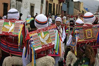
Qhapaq Qulla is a folk dance in Peru. It is performed at festivals of the Cusco Region, such as Mamacha Carmen in Paucartambo and the important Quyllur Rit'i at the Winter Solstice on the mountain Qullqipunku.

Jatun Quenamari is a mountain in the Vilcanota mountain range in the Andes of Peru, about 5,400 metres (17,717 ft) high. It is situated in the Puno Region, Carabaya Province, Corani District. Jatun Quenamari lies east of the large glaciated area of Quelccaya, southwest of Cuncunani.
Qhapaq Kancha is an archaeological site in Peru of the Inca period on top of a mountain of the same name. It is located in the Cusco Region, Calca Province, Coya District.
