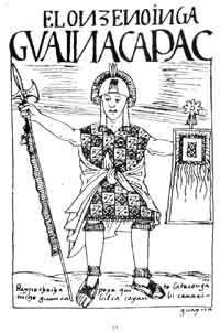
Huayna Capac, Guayna Cápac, Guayna Capac, Huain Capac, Guain Capac, Guayana Capac, Wayna Kapa, Wayn Capac, Wayana Qhapaq, Wayna Kapak, Wayna Capac, or Wayna Qhapaq (1464/1468–1527) was the third Sapan Inka of the Inca Empire, born in Tumipampa sixth of the Hanan dynasty, and eleventh of the Inca civilization. As other Sapa Inkas, Wayna Qhapaq subjects commonly approached him adding epithets and titles when addressing him, commonly as Wayna Qhapaq Inka Sapa'lla Tukuy Llaqt'a Uya "Unique Sovereign Wayna Qhapaq Listener of All Peoples", His original name was Titu Kusi Wallpa. He was the successor to Tupaq Inka Yupanki.

Palcaraju is a mountain in the Cordillera Blanca mountain range in the region of Ancash within the Peruvian Andes. It has an elevation of 6,274 metres (20,584 ft) on its main summit.
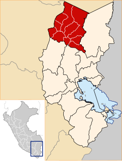
Carabaya Province is a province of the Puno Region in the southern part of Peru. It is bounded on the north by the Madre de Dios Region, on the east by the Sandia Province, on the south by the provinces of Azángaro, Melgar and Putina and on the west by the Cusco Region. The capital of the province is the city of Macusani.
The Cordillera Carabaya lies in the Andes of Peru. It extends between 14°00' and 14°22'S and 69°38' and 70°19'W for about 75 km. It is located in the Puno Region, Carabaya Province, between the Vilcanota mountain range in the north-west and the Apolobamba mountain range in the south-east, north and north-east of Macusani.

Huaynaccapac is a mountain in the Andes of Peru. It is one of the highest peaks of the Carabaya mountain range rising up to 5,721 metres (18,770 ft). Huaynaccapac is located in the Puno Region, Carabaya Province, north or northeast to east of Allincapac, the highest mountain of the range.
Chichicapac is a mountain in the Andes of Peru. It is one of the highest peaks of the Carabaya mountain range rising up to 5,614 metres (18,419 ft). Chichicapac is located in the Puno Region, Carabaya Province, on the border of the districts of Ayapata and Macusani. It lies southeast of the higher mountains Huaynaccapac and Allincapac and northeast of the lake Chaupicocha.
Mawk'allaqta, also Mawk'a Llaqta, is an archaeological site in Peru. It is located in the Puno Region, Sandia Province, Sandia District. The site was declared a National Cultural Heritage (Patrimonio Cultural) of Peru by the National Institute of Culture.
Mawk'allaqta or Mawk'a Llaqta is an archaeological site in Peru. It is located in the Cusco Region, Paruro Province, Paccaritambo District, near Mullipampa (Mollebamba).
Anahuarque is a mountain in the Andes of Peru southeast of the city of Cusco, about 4,050 metres (13,287 ft) high. It is located in the Cusco Region, Cusco Province, in the districts San Sebastián and Santiago, west of the mountain Wanakawri.
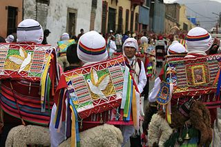
Qhapaq Qulla is a folk dance in Peru. It is performed at festivals of the Cusco Region, such as Mamacha Carmen in Paucartambo and the important Quyllur Rit'i at the Winter Solstice on the mountain Qullqipunku.

Ch'unchu is a folk dance in Peru. It is performed on festivals of the Cusco Region like Mamacha Carmen in Paucartambo and Quyllur Rit'i. Varieties include q'ara ch'unchu, qhapaq ch'unchu and wayri ch'unchu.
Jatuncucho is a mountain in the Vilcanota mountain range in the Andes of Peru, about 5,400 metres (17,717 ft) high. It is situated in the Cusco Region, Canchis Province, San Pablo District, in the Puno Region, Carabaya Province, Corani District, and in the Melgar Province, Nuñoa District. Jatuncucho lies between Pomanota in the north-west and Jonorana in the east and north-east of the mountain Cochacucho.
Ancayoc Cucho is a mountain in the Andes of Peru, about 5,000 metres (16,404 ft) high. It is located in the Puno Region, Sandia Province, Limbani District.
Quello Sallayoc is a mountain in the Vilcanota mountain range in the Andes of Peru, about 5,000 metres (16,404 ft) high. It is located in the Puno Region, Carabaya Province, on the border of the districts Corani and Ollachea. Quello Sallayoc lies south-east of the mountains Llusca Ritti (Cusco-Puno), Jori Pintay and Taruca Sayana, west of the mountain Riti Huasi and northwest of the mountains Yana Sallayoc and Llusca Ritti. Its ridge stretches to the northeast.
Jalahuana or Jalahuaña is a 5,325-metre-high (17,470 ft) mountain in the Andes of Peru. It is located in the Puno Region, Carabaya Province, Crucero District, and in the Sandia Province, on the border of the Limbani District and the Patambuco District. Jalahuana lies east of Aricoma Lake between the mountain Aricoma in the northwest and Riticunca in the southeast to south.

Jatun Quenamari is a mountain in the Vilcanota mountain range in the Andes of Peru, about 5,400 metres (17,717 ft) high. It is situated in the Puno Region, Carabaya Province, Corani District. Jatun Quenamari lies east of the large glaciated area of Quelccaya, southwest of Cuncunani.
Pata Anjasi is a mountain in the Vilcanota mountain range in the Andes of Peru, about 5,000 metres (16,404 ft) high. It is located in the Puno Region, Carabaya Province, Corani District. Pata Anjasi is situated east of the large glaciated area of Quelccaya and the peaks of Jatun Quenamari, and southeast of Cuncunani.
Jatun Huaychahui also known as Huaychahui, is a 5,445-metre-high (17,864 ft) mountain in the Andes of Peru. It is the highest mountain in the Huanzo mountain range. Jatun Huaychahui is located in the Arequipa Region, on the border of the Condesuyos Province, Cayarani District, and the La Unión Province, Puyca District, and in the Cusco Region, Chumbivilcas Province, Santo Tomás District. It lies southwest of Huiscatongo.
Runcu Tauja is a mountain in the Vilcanota mountain range in the Andes of Peru, about 5,200 metres (17,060 ft) high. It is located in the Cusco Region, Canchis Province, Checacupe District, and in the Puno Region, Carabaya Province, Corani District. Runcu Tauja lies northwest of the glaciated area of Quelccaya, west of Quimsachata and north of Millo.
Tucuhuachana is mountain in the Carabaya mountain range in the Andes of Peru, about 5,000-metre (16,000 ft) high. It is located in the Puno Region, Carabaya Province, Ituata District. Tucuhuachana lies southwest of Pumajolluni, northeast of Queroni and southeast of Allpajata. The little lake east of it is named Vilajota.


