Allincapac,Allin Ccapac or Allin Japac is a mountain in the Andes of Peru. It is the highest peak of the Carabaya mountain range, rising up to 5,805 metres (19,045 ft). Allincapac is located in the Puno Region, Carabaya Province, Macusani District, south of Huaynaccapac, northeast of Chichicapac and north of Lake Chaupicocha.
Jatun Pinguilluni is a mountain in the Carabaya mountain range in the Andes of Peru, about 5,100 metres (16,732 ft) high. It is located in the Puno Region, Carabaya Province, on the border of the districts Ajoyani and Coasa. Jatun Pinguilluni lies southeast of a lake named Pampacocha.
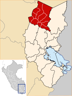
Pampaqucha is a lake in the Andes of Peru. It is located in the Puno Region, Carabaya Province, Ajoyani District. Pampaqucha lies northwest of the peak of Hatun Pinkilluni.
Kimsaqucha is a group of three lakes in Peru located in the Puno Region, Carabaya Province, Ituata District. The lakes lie north-east of the Kallawaya mountain range, at the foot of the mountain Yana Wayllayuq.
Macho Ritti is a mountain in the Vilcanota mountain range in the Andes of Peru, about 5,200 metres (17,060 ft) high. It is located in the Puno Region, Carabaya Province, on the border of the districts Corani and Ollachea. Macho Ritti lies north-west of the lakes Mancacocha and Jomercocha and north of the mountain Ananta.
Riti Huasi is a mountain in the Vilcanota mountain range in the Andes of Peru, about 5,000 metres (16,404 ft) high. It is situated in the Puno Region, Carabaya Province, on the border of the districts Corani and Ollachea.
Lake Chaupicocha is a lake in Peru located in the Lima Region, Oyón Province, Oyón District. It lies north of the mountain Garguac.
Jatuncucho is a mountain in the Vilcanota mountain range in the Andes of Peru, about 5,400 metres (17,717 ft) high. It is situated in the Cusco Region, Canchis Province, San Pablo District, in the Puno Region, Carabaya Province, Corani District, and in the Melgar Province, Nuñoa District. Jatuncucho lies between Pomanota in the north-west and Jonorana in the east and north-east of the mountain Cochacucho.
Hatunqucha is a lake in the Altiplano in South Peru. It lies in the Puno Region, Puno Province, Atuncolla District, north of Lake Umayo.
Qillwaqucha Urqu is a mountain in the Andes of Peru, about 4,174 metres (13,694 ft) high. It is situated in the Puno Region, Carabaya Province, on the border of the districts Ollachea and San Gaban. Qillwaqucha Urqu lies north of the river Khichumayu whose waters flow to the Inambari River.
Riticocha is a mountain in the Vilcanota mountain range in the Andes of Peru, about 5,100 metres (16,732 ft) high. It is located in the Puno Region, Carabaya Province, Ollachea District. Riticocha lies north-east of the mountains Ananta and Macho Ritti and the lakes Mancacocha and Jomercocha.
Tocra is a mountain in the Vilcanota mountain range in the Andes of Peru, about 5,000 metres (16,404 ft) high. It is situated in the Puno Region, Carabaya Province, on the border of the districts Corani and Ollachea. Tocra lies east of the mountain Macho Ritti and northeast of the mountain Ananta. The lakes Mancacocha and Jomercocha lie south of Tocra.
Riticunca is a mountain in the Andes of Peru, about 5,000 metres (16,404 ft) high. It is located in the Puno Region, Carabaya Province, Crucero District, and in the Sandia Province, Patambuco District, northwest of the mountain Laramani. East of Riticunca there is a group of small lakes, among them Riticocha and Yanacocha. The lake Jochajucho is situated in the Ritipata valley southeast of the mountain.
Lake Veluyoc Cocha is a lake in the Andes of Peru. It is situated in the Puno Region, Carabaya Province, Crucero District. It lies southwest of the mountain Veluyoc Orjo and west of the mountain Aricoma and Lake Aricoma.

Cunorana is a mountain in the Vilcanota mountain range in the Andes of Peru, about 5,300 metres (17,388 ft) high. It is situated in the Puno Region, Carabaya Province, Corani District. Cunorana lies southeast of Millo in the northeastern part of the large glaciated area of Quelccaya.
Yurac Huayruro is a mountain in the Vilcanota mountain range in the Andes of Peru, about 5,000 metres (16,404 ft) high. It is located in the Puno Region, Carabaya Province, Corani District, northeast of the large glaciated area of Quelccaya. Yurac Huayruro lies northwest of Tarucani and Jachatira and northeast of Cunorana.
Jatun Quenamari is a mountain in the Vilcanota mountain range in the Andes of Peru, about 5,400 metres (17,717 ft) high. It is situated in the Puno Region, Carabaya Province, Corani District. Jatun Quenamari lies east of the large glaciated area of Quelccaya, southwest of Cuncunani.
Allpajata is mountain in the Carabaya mountain range in the Andes of Peru, about 5,100-metre (16,700 ft) high. It is located in the Puno Region, Carabaya Province, on the border of the districts of Ituata and Macusani. Allpajata lies northwest of Queroni, and east and southeast of the lake and the mountain named Tocsajota.
Tucuhuachana is mountain in the Carabaya mountain range in the Andes of Peru, about 5,000-metre (16,000 ft) high. It is located in the Puno Region, Carabaya Province, Ituata District. Tucuhuachana lies southwest of Pumajolluni, northeast of Queroni and southeast of Allpajata. The little lake east of it is named Vilajota.
Quellhuacotarriti is a mountain in the Carabaya mountain range in the Andes of Peru, about 5,200 m (17,100 ft) high. It is located in the Puno Region, Carabaya Province, Macusani District. Quellhuacotarriti lies southwest of Allincapac and south of Vela Cunca.