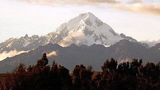
Veronica, also called Huacrahuilki, Huacay Huilcay, Wayna Willka,Waqaywillka, Urubamba, or Padre Eterno, is a 5,893 m (19,334 ft) mountain in the Urubamba mountain range in the Andes of Peru. It is located in the Cusco Region, La Convención Province, Huayopata District, and in the Urubamba Province, Ollantaytambo District northwest of the town of Ollantaytambo.

Pucaranra is a mountain in the Cordillera Blanca in the Andes of Peru, about 6,147 metres (20,167 ft) high (although other sources cite an elevation of 6,156 metres. It is located in Ancash, southwest of mount Chinchey.
The Cordillera Carabaya lies in the Andes of Peru. It extends between 14°00' and 14°22'S and 69°38' and 70°19'W for about 75 km. It is located in the Puno Region, Carabaya Province, between the Vilcanota mountain range in the north-west and the Apolobamba mountain range in the south-east, north and north-east of Macusani.

Allincapac,Allin Ccapac or Allin Japac is a mountain in the Andes of Peru. It is the highest peak of the Carabaya mountain range, rising up to 5,805 metres (19,045 ft). Allincapac is located in the Puno Region, Carabaya Province, Macusani District, south of Huaynaccapac, northeast of Chichicapac and north of Lake Chaupicocha.
Jatunhuma, Jatunpampa or Pico Tres is a mountain in the Vilcanota mountain range in the Andes of Peru, about 6,093 metres (19,990 ft) high. It is situated in the Cusco Region, Canchis Province, Pitumarca District, and in the Quispicanchi Province, Ocongate District. Hatunuma lies northwest of the large lake named Sibinacocha and southeast of Callangate.
Wamanrasu is a mountain in the Chunta mountain range in the Andes of Peru, about 5,304 metres (17,402 ft) high. It is located in the Huancavelica Region, Castrovirreyna Province, Santa Ana District and in the Huancavelica Province, Huancavelica District. Wamanrasu lies northeast of the mountain Antarasu and northwest of the mountain Qarwarasu (Carhuarazo) of the Huancavelica Region.
Huaynaccapac is a mountain in the Andes of Peru. It is one of the highest peaks of the Carabaya mountain range rising up to 5,721 metres (18,770 ft). Huaynaccapac is located in the Puno Region, Carabaya Province, north or northeast to east of Allincapac, the highest mountain of the range.
Choquetacarpo is a 5,520 metres (18,110 ft) high mountain in the Vilcabamba mountain range in the Andes of Peru. It is located in the Cusco Region, La Convención Province, in the districts Santa Teresa and Vilcabamba. Choquetacarpo lies northwest of the Pumasillo peak. The little river Moyoc (Muyuq) originates east of the mountain. It flows to the south as an affluent of the Yanama River.
Choquesafra or Choquezafra is a 5,152-metre-high (16,903 ft) mountain in the Vilcabamba mountain range in the Andes of Peru. It is located in the Cusco Region, La Convención Province, on the border of the districts of Inkawasi and Vilcabamba. Choquesafra lies west of the Panta group and south of a river named Rancahuayco. The Huajchay River originates northwest of the mountain. It flows to the southwest as a right affluent of the Apurímac River.
Jatuncucho is a mountain in the Vilcanota mountain range in the Andes of Peru, about 5,400 metres (17,717 ft) high. It is situated in the Cusco Region, Canchis Province, San Pablo District, in the Puno Region, Carabaya Province, Corani District, and in the Melgar Province, Nuñoa District. Jatuncucho lies between Pomanota in the north-west and Jonorana in the east and north-east of the mountain Cochacucho.
Ancayoc Cucho is a mountain in the Andes of Peru, about 5,000 metres (16,404 ft) high. It is located in the Puno Region, Sandia Province, Limbani District.
Corihuayrachina erroneously also Corihuaynachina, is a mountain in the Vilcabamba mountain range in the Andes of Peru, about 5,404 metres (17,730 ft) high. It is situated in the Cusco Region, La Convención Province, Vilcabamba District, at a little lake named Corihuayrachina. Corihuayrachina lies south of the Pumasillo massif and west of Padreyoc. The archaeological sites of Corihuayrachina and Choquequirao are west and southwest of the mountain Corihuayrachina.
Quello Sallayoc is a mountain in the Vilcanota mountain range in the Andes of Peru, about 5,000 metres (16,404 ft) high. It is located in the Puno Region, Carabaya Province, on the border of the districts Corani and Ollachea. Quello Sallayoc lies south-east of the mountains Llusca Ritti (Cusco-Puno), Jori Pintay and Taruca Sayana, west of the mountain Riti Huasi and northwest of the mountains Yana Sallayoc and Llusca Ritti. Its ridge stretches to the northeast.
Yana Sallayoc is a mountain in the Vilcanota mountain range in the Andes of Peru, about 5,000 metres (16,404 ft) high. It is lies in the Puno Region, Carabaya Province, Corani District. Yana Sallayoc is situated south of the mountains Quello Sallayoc and Llusca Ritti, east of the mountain Tica Pallana and west of the mountain Viscachani.
Huancane Apacheta is a mountain in the Vilcanota mountain range in the Andes of Peru, about 5,200 metres (17,060 ft) high. It is located in the Cusco Region, Canchis Province, Checacupe District, and in the Puno Region, Carabaya Province, Corani District. Huancane Apacheta lies between the mountain Otoroncane in the northeast and Tutallipina and Sayrecucho in the southwest.
Sayrecucho is a mountain in the Vilcanota mountain range in the Andes of Peru, about 5,200 metres (17,060 ft) high. It is situated in the Cusco Region, Canchis Province, Checacupe District, and in the Puno Region, Carabaya Province, Corani District. Sayrecucho lies southeast of the mountains Otoroncane and Huancane Apacheta, northwest of Culi and north of Tutallipina. The river Huancane originates north of Sayrecucho. Its waters flow to the Vilcanota River.

Jatun Quenamari is a mountain in the Vilcanota mountain range in the Andes of Peru, about 5,400 metres (17,717 ft) high. It is situated in the Puno Region, Carabaya Province, Corani District. Jatun Quenamari lies east of the large glaciated area of Quelccaya, southwest of Cuncunani.
Pata Anjasi is a mountain in the Vilcanota mountain range in the Andes of Peru, about 5,000 metres (16,404 ft) high. It is located in the Puno Region, Carabaya Province, Corani District. Pata Anjasi is situated east of the large glaciated area of Quelccaya and the peaks of Jatun Quenamari, and southeast of Cuncunani.
Runcu Tauja is a mountain in the Vilcanota mountain range in the Andes of Peru, about 5,200 metres (17,060 ft) high. It is located in the Cusco Region, Canchis Province, Checacupe District, and in the Puno Region, Carabaya Province, Corani District. Runcu Tauja lies northwest of the glaciated area of Quelccaya, west of Quimsachata and north of Millo.
Tucuhuachana is mountain in the Carabaya mountain range in the Andes of Peru, about 5,000-metre (16,000 ft) high. It is located in the Puno Region, Carabaya Province, Ituata District. Tucuhuachana lies southwest of Pumajolluni, northeast of Queroni and southeast of Allpajata. The little lake east of it is named Vilajota.


