Huimbayoc District

Last updated
Huimbayoc
Wimpayuq
District

Cordillera Azul NP 2007.jpg

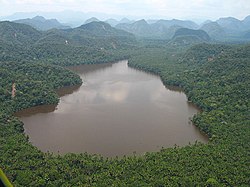
Laguna del Mundo Perdido, Huimbayoc District, Cordillera Azul National Park
Country Flag of Peru.svg  Peru
Region San Martín
Province San Martín
Founded December 30, 1953
Capital Huimbayoc
Government
   Mayor Lucas Reynaldo Arevalo Cumapa
Area
  Total 1,609.07 km2 (621.27 sq mi)
Elevation 120 m (390 ft)
Population (2005 census)
  Total 4,539
  Density 2.8/km2 (7.3/sq mi)
Time zone PET (UTC-5)
UBIGEO 220907

Huimbayoc or Wimpayuq (Quechua) is one of fourteen districts of the province San Martín in Peru. [1]

Districts of Peru third level administrative subdivision of Peru

The districts of Peru are the third-level country subdivisions of Peru. They are subdivisions of the provinces, which in turn are subdivisions of the larger regions or departments. There are 1,838 districts in total.

San Martín Province Province in San Martín, Peru

The San Martín Province is one of 10 provinces of the San Martín Region in northern Peru.

Peru republic in South America

Peru, officially the Republic of Peru, is a country in western South America. It is bordered in the north by Ecuador and Colombia, in the east by Brazil, in the southeast by Bolivia, in the south by Chile, and in the west by the Pacific Ocean. Peru is a megadiverse country with habitats ranging from the arid plains of the Pacific coastal region in the west to the peaks of the Andes mountains vertically extending from the north to the southeast of the country to the tropical Amazon Basin rainforest in the east with the Amazon river.

Part of the district is located in the Cordillera Azul National Park.

Cordillera Azul National Park National Park in Peru

Cordillera Azul National Park is a protected area in Peru. It protects part of the Ucayali moist forests ecoregion.

Related Research Articles

Llanbethery is a small village in the Vale of Glamorgan, south Wales. It is part of the community of Llancarfan.

Chadin District is one of nineteen districts of the province Chota in Peru.

La Florida District is one of thirteen districts of the province San Miguel in Peru.

San Luis de Shuaro District District in Junín, Peru

San Luis de Shuaro District is one of six districts of the province Chanchamayo in Peru.

San Jerónimo de Tunán District is one of twenty-eight districts of the province Huancayo in Peru.

San Pedro de Chunan District is one of thirty-four districts of the province Jauja in Peru.

San Juan de Jarpa District is one of nine districts of the province Chupaca in Peru.

Tres de Diciembre District is one of nine districts of the province Chupaca in Peru.

Hongos District is one of thirty-three districts of the province Yauyos in Peru.

Tupe District is one of thirty-three districts of the province of Yauyos in Peru. It is home to the Jaqaru ethnolinguistic minority.

Acobambilla District is one of nineteen districts of the Huancavelica Province in Peru.

Alto Tapiche District is one of eleven districts of the province Requena in Peru.

Maquia District is one of eleven districts of the province Requena in Peru.

Sarayacu District is one of six districts of the province Ucayali in Peru.

Vargas Guerra District is one of six districts of the province Ucayali in Peru.

Teniente César López Rojas District is one of six districts of the province Alto Amazonas in Peru. The district was established on 8 September 1964.

Chipurana District is one of fourteen districts of the province San Martín in Peru.

El Porvenir District is one of fourteen districts of the province San Martín in Peru.

Papaplaya District is one of fourteen districts of the province San Martín in Peru.

Obas District is one of eight districts of the province Yarowilca in Peru.

References

Coordinates: 6°25′08″S75°46′16″W / 6.4190°S 75.7710°W / -6.4190; -75.7710

Geographic coordinate system Coordinate system

A geographic coordinate system is a coordinate system that enables every location on Earth to be specified by a set of numbers, letters or symbols. The coordinates are often chosen such that one of the numbers represents a vertical position and two or three of the numbers represent a horizontal position; alternatively, a geographic position may be expressed in a combined three-dimensional Cartesian vector. A common choice of coordinates is latitude, longitude and elevation. To specify a location on a plane requires a map projection.