Cordillera Azul National Park

Last updated
Cordillera Azul National Park
Cordillera Azul NP 2007.jpg
Lake at Cordillera Azul National Park
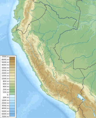
Peru physical map.svg
Red pog.svg
Location Peru
Loreto, San Martín, Huánuco and Ucayali
Nearest city Tarapoto
Coordinates 7°45′S75°56′W / 7.75°S 75.94°W / -7.75; -75.94 [1]
Area1,353,190 hectares (5,224.7 sq mi)
EstablishedMay 21, 2001
Governing body SERNANP
Website Parque Nacional Cordillera Azul

Cordillera Azul National Park (Spanish : Parque Nacional Cordillera Azul) is a protected area in Peru. [3] It protects part of the Ucayali moist forests ecoregion. [4]
Contents

History

In 1963, the Biavo-Cordillera Azul National Forest was established, spanning 2,178,000 hectares. [5] In 1997, this area is declared as a forest for timber production, leaving it open to logging operations. However, in 1999, Red Ambiental Peruana (an alliance of several NGOs) and COPRI (the authority for rights for timber exploitation) conduct research in the area and agree to protect the northern part of the forest due to its high biodiversity. [5] In 2000, the Cordillera Azul Reserved Zone is established on the mountainous part of the national forest, and a team from the Field Museum begins an assessment of the biodiversity in the area. Based on such assessment, the Peruvian Ministry of Agriculture recommends the area is protected as a national park. [5] The Cordillera Azul National Park was established in 2001 during the tenure of president Valentín Paniagua. [5] [6]

Geography

Cordillera Azul National Park is located in the regions of San Martin, Loreto, Huanuco and Ucayali; between the Huallaga and Ucayali rivers. [7] Elevations in the park are in the range of 100–2350 m, and the main landscape features are: mountains, hills and ample valleys. [7] Mountains inside the park can have steep slopes, and landslides are frequent. [7] In the southern section of the park, there is an area of highland swamps, at 1400 m of elevation. [7] At the northern end of the park, the Huallaga river opens a water gap in the mountain range, east of Chazuta, this feature is known as Pongo de Aguirre. [7]

Ecology

Flora

Montane forests cover most of the park's area, although it also includes sections of dry forest to the west and lowland Amazon rainforest to the east. [3] Among the plant species found in the area are: Ceiba insignis, Ficus spp., Tabernaemontana sananho, Inga spp., Swietenia macrophylla, Triplaris americana, Miconia spp., Couroupita guianensis, Ocotea javitensis, Sciodaphyllum spp., Erythrina ulei, Alchornea triplinervia, Terminalia amazonia, Calophyllum brasiliense, Pouteria spp., Cedrela fissilis, Epidendrum spp., Schizolobium parahyba, Bactris gasipaes, Cecropia spp., Hevea guianensis , Dracontium spruceanum, Attalea maripa, Brosimum alicastrum, Asplenium serratum, Heliconia rostrata, Carludovica palmata, Solanum grandiflorum, Geogenanthus poeppigii, Myroxylon balsamum, Brunfelsia grandiflora, Calycophyllum spruceanum , Mauritia flexuosa , Virola calophylla, Desmoncus polyacanthos, Podocarpus oleifolius, Theobroma cacao, Cedrelinga cateniformis, Zamia poeppigiana, Amburana cearensis , Margaritaria nobilis, Jacaranda copaia, Eugenia spp., Spondias mombin, Maxillaria graminifolia, etc. [8] [9]

Fauna

Among the fish found in the park are: Hoplias malabaricus, Rineloricaria lanceolata, Leporinus spp., Piaractus brachypomus, Pseudoplatystoma fasciatum, Zungaro zungaro, Crossoloricaria rhami, etc. [8]

Some of the birds found in the park are: the great tinamou, the fasciated tiger heron, the scarlet macaw, the osprey, the muscovy duck, the violet-headed hummingbird, the sunbittern, the short-tailed parrot, the white-booted racket-tail, the king vulture, the little blue heron, the harpy eagle, the jabiru, the blue-and-yellow macaw, the fork-tailed palm swift, the Cordillera Azul antbird, etc. [8] [10]

Mammals reported in the area include: the Amazon dwarf squirrel, the bush dog, the puma, the common opossum, the brown-mantled tamarin, the Peruvian spider monkey, the jaguar, the white-lipped peccary, the red brocket, the South American tapir, the tayra, etc. [8]

Environmental issues

Illegal road building and clearing of forests for agriculture occurs inside the park; park rangers and inhabitants of nearby villages patrol the area. [11]

Related Research Articles

<span class="mw-page-title-main">Department of San Martín</span> Departments of Peru

San Martín is a department and region in northern Peru. Most of the department is located in the upper part of the Peruvian Amazon rainforest. Its capital is Moyobamba and the largest city in the department is Tarapoto.

<span class="mw-page-title-main">Manu National Park</span> National park in Peru

Manu National Park is a national park and biosphere reserve located in the regions of Madre de Dios and Cusco in Peru. It protects a diverse number of ecosystems including lowland rainforests, cloud forests and Andean grasslands.

<span class="mw-page-title-main">Huascarán National Park</span> World Heritage Site and national park in Peru

Huascarán National Park is a Peruvian national park that comprises most of the mountain range known as Cordillera Blanca which is part of the central Andes, in the region of Ancash. The park covers an area of 340,000 hectares and is managed by the Peruvian Network of Protected Natural Areas, or SERNANP. It was designated as a World Heritage Site in 1985 by UNESCO, is also a well-known mountaineering spot, and harbors a unique biodiversity with plant species such as the Queen of the Andes, trees of the genera Polylepis and Buddleja, and animals such as spectacled bears, condors, vicunas, and tarucas.

<span class="mw-page-title-main">Cerros de Amotape National Park</span>

Cerros de Amotape National Park is a protected area located in the regions of Piura and Tumbes in northern Peru.

<span class="mw-page-title-main">Rio Abiseo National Park</span>

The Rio Abiseo National Park is located in the San Martín department of Peru. UNESCO pronounced it as Natural and Cultural Heritage of Humanity in 1990. The park is home to many species of flora and fauna, as well as the location of over 30 pre-Columbian archaeological sites. Since 1986, the park has not been open to tourism due to the fragile nature of both the natural and archaeological environment.

<span class="mw-page-title-main">Cutervo National Park</span> National park in Peru

Cutervo National Park , established in 1961, is the oldest protected area in Peru. It is located in the northern Peruvian Andes, in the region of Cajamarca. The park was extended to 8,214 hectares (31.71 sq mi) and protects areas of Andean montane forests and paramo for headwater conservation. Moreover, those areas are the habitat of animal species like the spectacled bear, the mountain tapir, and the oilbird; and plant species like the Andean wax palms.

<span class="mw-page-title-main">Tingo María National Park</span>

Tingo María National Park is located in the districts of Rupa Rupa and Mariano Dámaso, in the region of Huánuco, Peru. It was established on May 14, 1965 and its main attractions are the montane forest vegetation and the cave named Cueva de las Lechuzas where the oilbirds nest. The park has an area of 4,777 hectares (18.44 sq mi) that include a mountain massif called La Bella Durmiente.

<span class="mw-page-title-main">Yanachaga–Chemillén National Park</span>

Yanachaga–Chemillén National Park is a protected area located in the region of Pasco, Peru. It preserves part of the rainforests and cloud forests of central Peru.

<span class="mw-page-title-main">Bahuaja-Sonene National Park</span>

Bahuaja-Sonene National Park is a protected area located in the regions of Puno and Madre de Dios, in Peru.

Tabaconas-Namballe National Sanctuary is a national sanctuary in Peru established in 1988, and protects the southernmost part of the páramo ecosystem. It is located in San Ignacio Province, Cajamarca and spans an area of 32,124.87 ha.

Tumbes National Reserve is a protected area established in 2006 and located in the region of Tumbes, Peru; near the border with Ecuador. It spans an area of 751 km2 (290 sq mi) and along with Cerros de Amotape National Park and El Angolo Game Preserve is part of the Noroeste Biosphere Reserve designated by UNESCO.

Güeppi-Sekime National Park is a protected area located in the Peruvian region of Loreto, on the border with Ecuador. The park encompasses 203,628.51 hectares (2,036 km2) of forests in a landscape that features hills and seasonally flooded lowlands.

<span class="mw-page-title-main">Tambopata National Reserve</span> Peruvian nature reserve

Tambopata National Reserve is a Peruvian nature reserve located in the southeastern region of Madre de Dios. It was established on September 4, 2000, by decree of President Alberto Fujimori. The reserve protects several ecosystems of the tropical rainforest for the preservation of such forest and the sustainable use of forest resources by the peoples around the reserve.

<span class="mw-page-title-main">Pacaya-Samiria National Reserve</span> Peruvian nature reserve

Pacaya–Samiria National Reserve, is a protected area located in the region of Loreto, Peru and spans an area of 20,800 km2 (8,000 sq mi). It protects an area of low hills and seasonally flooded forest in the Amazon rainforest. Pacaya-Samiria National Reserve and the near Tamshiyacu-Tahuayo Reserve both forms a biodiversity hotspot in the Amazon jungle.

Alto Purús National Park is a national park in the Amazon rainforest of Peru, established in 2004. It covers an area of 2,510,694.41 ha (9,693.85 sq mi) in the provinces of Purús (Ucayali), Tahuamanu and Tambopata.

El Sira Communal Reserve is a protected area in Peru created to preserve the biodiversity of the Sira Mountains and the ancestral sustainable use of the area's resources by the nearby native peoples. It also protects the headwaters of the Pachitea river basin. The reserve covers an area of 616,413 hectares (6,164.13 km2) within the regions of Huánuco, Pasco and Ucayali. The reserve was created in 2001 and in 2010, UNESCO recognized it as part of the Oxapampa-Asháninka-Yánesha Biosphere Reserve.

<span class="mw-page-title-main">Allpahuayo-Mishana National Reserve</span>

Allpahuayo-Mishana National Reserve is a protected area in Peru located southwest of Iquitos in the region of Loreto. It was established in 2004 to protect the diverse forest types in the area, especially the rainforests on white sandy soil and watercourses which provide drinking water to the city of Iquitos.

The Ichigkat Muja – Cordillera del Condor National Park is a protected area in Peru located in the region of Amazonas. It protects part of the Eastern Andes forests at the Cordillera del Condor mountain range.

<span class="mw-page-title-main">Cordillera Azul antbird</span> Species of bird

The Cordillera Azul antbird is a Near Threatened species of passerine bird in subfamily Thamnophilinae of family Thamnophilidae, the "typical antbirds". It is found only in the Cordillera Azul, San Martín Region, Peru.

Tatamá National Natural Park is a national park in the Cordillera Occidental, Colombia. Established in 1987, the park encompasses 51,900 ha of primary west-Andean tropical and subtropical rainforest, temperate cloud forest, and páramo habitat in an area that spans the departments of Risaralda, Chocó and Valle del Cauca, within the Chocó bioregion.

References

  1. "Cordillera Azul National Park". protectedplanet.net.
  2. "Cordillera Azul National Park". protectedplanet.net.
  3. 1 2 "Cordillera Azul - Servicio Nacional de Áreas Naturales Protegidas por el Estado". www.sernanp.gob.pe (in European Spanish). Archived from the original on 2016-09-18. Retrieved 2017-06-16.
  4. "Ucayali moist forests", Global Species, Myers Enterprises II, retrieved 2017-04-30
  5. 1 2 3 4 Parque Nacional Cordillera Azul. Diagnóstico del Proceso de Actualización Plan Maestro 2011-2016 (in Spanish). CIMA. 2012. ISBN   978-612-46157-0-2.
  6. "Cordillera Azul : Park Story". fm2.fieldmuseum.org. Retrieved 2017-06-16.
  7. 1 2 3 4 5 Cordillera Azul. Plan Maestro 2003-2008. INRENA. 2006. p. 50.
  8. 1 2 3 4 Rapid Biological Inventories: Biabo - Cordillera Azul. Field Museum. pp. 160–194.
  9. Atwood, John T. (2003). "Review of the Maxillaria graminifolia (Kunth) Rchb.F. (Orchidaceae) Suballiance". Selbyana. 24 (2): 144–164. JSTOR   41760129.
  10. Moncrieff, A.E.; Johnson, O.; Lane, D.F.; Beck, J.R.; Angulo, F.; Fagan, J. (2018). "A new species of antbird (Passeriformes: Thamnophilidae) from the Cordillera Azul, San Martin, Peru". Auk. 135 (1): 114–126. doi: 10.1642/AUK-17-97.1 .
  11. "Protection of Cordillera Azul, CIMA". www.cima.org.pe. Retrieved 2018-10-30.