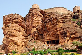
Badami, formerly known as Vātāpi [Sanskrit: from āpi, ‘friend, ally’; ‘having the wind (vāta) as an ally’], is a town and headquarters of a taluk by the same name, in the Bagalkot district of Karnataka, India. It was the regal capital of the Badami Chalukyas from 540 to 757. It is famous for its rock cut monuments such as the Badami cave temples, as well as the structural temples such as the Bhutanatha temples, Badami Shivalaya and Jambulingesvara Temple. It is located in a ravine at the foot of a rugged, red sandstone outcrop that surrounds Agastya lake.

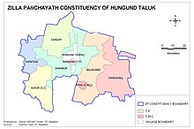
Bagalakote district, is an administrative district in the Indian state of Karnataka. The district headquarters is located in the town of Bagalakote. The district is located in northern Karnataka and borders Belgaum, Gadag, Koppal, Raichur and Bijapur. The new Bagalakote district was carved out of Vijayapura in 1997 via Government of Karnataka directive Notification RD 42 LRD 87 Part III. The bifurcated Bagalakote district consists of ten taluks — Badami, Bagalakote, Bilagi, Guledgudda, Rabkavi Banhatti, Hunagund, Ilkal, Jamakhandi and Mudhol, Teradal.
Kanakapura is a town in the Ramanagara district of Karnataka on the banks of the Arkavathi river and the administrative center of the taluk of the same name. Previously belonged to Bangalore Rural District. It was formerly the largest constituency in the country. The taluk is very widespread (1,553 km2 [600 sq mi]). It is located among the lush green forests of the state of Karnataka. The town is a tourism hotspot and an often visited tourist favorite in the entire state of Karnataka, as it has something for everyone ranging from avid trekkers to history buffs and wildlife enthusiasts.The forest area in this taluk is very wide and about half of the Bannerghatta National Park is located in our Kanakapura area.Kodihalli wildlife range and harohalli wildlife range its division.The Kaveri Wildlife Sanctuary consists of two main zones namely the Sangam Wildlife range, the Mugur Wildlife range
Arkalgud, also known as Arakalagudu is a panchayat town and is one among the eight taluks of Hassan district in the state of Karnataka, India. It is situated 30 km from Hassan, 181 km from Mangalore and 195 km from Bangalore. The river Hemavati forms the entire northern boundary of the Taluk; river Kaveri runs through a portion of the south. It is well connected by road to many towns and cities of Karnataka. Hassan Junction railway station is the nearest major railway station and Kannur International Airport is the nearest airport at 150 kilometres.
Badami Bagh is a cantonment town on the outskirts of Srinagar city in Srinagar district in the Indian union territory of Jammu and Kashmir. A portion of Indian army in the valley resides in the Badami Bagh cantonment. Badami Bagh Cantonment is the headquarters of the Indian Army's 15 Corps. The cantonment is established on the two road sides of Srinagar Jammu National Highway.

Basavakalyana is a historical city and municipal council in the Bidar District of the Indian state of Karnataka. It was the two Dynasties capital like Kalyani Chalukya and Kalachuris of Kalyani.It is famous for the world's largest Basavanna statue tall. It is one of the major city and industrial hub of Bidar district.
Chikkanayakanahalli is a town in Tiptur sub-division of Tumakuru district, in the state of Karnataka, India. It is 30 km away from Tiptur and 132 km from Bangalore.

Gajendragad is a Town Municipal Council city in Gadag District, Karnataka, India with Population of 32,359 as of 2011 Census data and is located at 15.73°N 75.98°E. It has an average elevation of 643 metres (2109 feet). This place is known for its hill station,hill strip, film shooting spots, Fort, kalakaleshwara temple, Market for Javali / Dress Materials for marriage & festivals, windmills, Handloom. It is about 55 kilometers from the district head quarter Gadag, 110 kilometers from Hubballi, 200 kilometers from Belagavi and 450 kilometers from state capital Bengaluru

Guledgudda is a town in the Indian state of Karnataka. It was earlier a part of the Badami taluk, but is now the headquarters of the Guledgudda taluk in Bagalkot district.
Hukkeri is a Town Municipal Council and taluka in Belgavi district in the Indian state of Karnataka.
Ilkal is a City in Bagalkot district in the Indian state of Karnataka. The town is located in a valley that lies in south-east corner of Bagalkot district and is quite close to the borders of Kushtagi taluk of the Koppal district.Now Ilkal city becomes taluk previous the city falls within the jurisdiction of Hungund taluk and lies at a distance of about 12 km (7.5 mi) south of taluk headquarters. Between these two towns, Ilkal is an important centre of trade, commerce, education, and industry. Ilkal is well connected with state and national highways. It is also famous for its hospitality and education institutions.
Kirtinagar is a town and a Nagar Panchayat and a Taluk in Tehri Garhwal district in the Indian state of Uttarakhand.
Kushtagi is a panchayat town in Koppal district in the Indian state of Karnataka. Kushtagi is a taluk center of Koppal district. This taluk has a population of 353,142 as per the 2021 census estimate. In this taluk, pomegranate fruits are popularly grown.There is a Durga devi temple in heart of the town. To its North lies Ilkal, Gajendragad to the West, Hospet to the South and Sindhanur to the East. Red and black soil can be found in this taluk. A big lake 4kms away from the city is the main source of drinking water is situated in west side and covering the area of more than 300 acres
Muddebihal is both a City and a Taluk in the Vijayapura district in the Indian state of Karnataka.
Sindagi is a City and Taluk in Vijayapura district in the Indian state of Karnataka, about 60 km to the east of Bijapur.

Turuvekere is a panchayat town and Taluk in Tumakuru district in the Indian state of Karnataka.

Channarayapatna is a town and Taluk headquarters in Hassan district of Karnataka, India. It lies on the Bangalore-Mangalore National Highway 75 in Karnataka, India.It has number of temples like Channakeshava temple, Anjaneya temple, Tejigereyamma temple... etc. Famous Jain pilgrimage Shravanabelagola belongs to this taluk. Channarayapatna has major railway connection from Bengaluru to Mangaluru, Karwar and Mysuru.
Mangalam is a census town in Tiruppur district in the Indian state of Tamil Nadu.
Aminagad is a village in the southern state of Karnataka, India. It is located in the Hungund taluk of Bagalkot district in Karnataka. Amingad is famous for its “Karadantu”. Karadantu is prepared using edible gum, dry fruits, sugar or jaggery. Amingad is also famous in cattle, Sheep, Lamb selling bazar in the state, bazar is on every Saturday, even sheep business from distant Tumukur and other parts of the state.

The following outline is provided as an overview of and topical guide to Karnataka: