Swiss German is any of the Alemannic dialects spoken in the German-speaking part of Switzerland and in some Alpine communities in Northern Italy bordering Switzerland. Occasionally, the Alemannic dialects spoken in other countries are grouped together with Swiss German as well, especially the dialects of Liechtenstein and Austrian Vorarlberg, which are closely associated to Switzerland's.

The Bernese Mountain Dog is a large-sized breed of dog, one of the four breeds of Sennenhund-type dogs from the Swiss Alps. The name Sennenhund is derived from the German Senne and Hund (hound/dog), as they accompanied the alpine herders and dairymen called Senn. Berner refers to the area of the breed’s origin, in the canton of Bern. This mountain dog was originally kept as a general farm dog. Large Sennenhunde in the past were also used as draft animals, pulling carts. The breed was officially established in 1907. In 1937, the American Kennel Club recognized it; today, the club classifies it as a member of the Working Group.

The canton of Bern or Berne is the second largest of the 26 Swiss cantons by both surface area and population. Located in west-central Switzerland, it borders the canton of Jura and the canton of Solothurn to the north. To the west lie the canton of Neuchâtel, the canton of Fribourg and canton of Vaud. To the south lies the canton of Valais. East of the canton of Bern lie the cantons of Uri, Nidwalden, Obwalden, Lucerne and Aargau.

The Lauberhorn is a mountain in the Bernese Alps of Switzerland, located between Wengen and Grindelwald, north of the Kleine Scheidegg. Its summit is at an elevation of 2,472 m (8,110 ft) above sea level.

Berner Sport Club Young Boys is a Swiss professional football club based in Bern, Switzerland, that plays in the Swiss Super League, the top tier in Swiss football. It is widely referred to as Young Boys, or as Young Boys Bern abroad, and is abbreviated to YB. The club's colors are yellow and black.

The Gletscherhorn is a mountain of the Bernese Alps, located on the border between the Swiss cantons of Bern and Valais. It forms the eastern edge of the Lauterbrunnen Wall, south of the Jungfrau.

Chillon Castle is an island castle located on Lake Geneva, south of Veytaux in the canton of Vaud. It is situated at the eastern end of the lake, on the narrow shore between Montreux and Villeneuve, which gives access to the Alpine valley of the Rhône. Chillon is amongst the most visited castles in Switzerland and Europe.
Bernese German is the dialect of High Alemannic German spoken in the Swiss plateau (Mittelland) part of the canton of Bern and in some neighbouring regions. A form of Bernese German is spoken by the Swiss Amish affiliation of the Old Order Amish in Adams County, Indiana, United States and their daughter settlements.

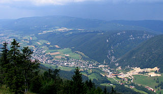
The Berner Oberland, is the higher part of the canton of Bern, Switzerland, in the southern end of the canton, and one of the canton's five administrative regions.
Bernese Jura is the name for the French-speaking area of the Swiss canton of Bern, and from 2010 one of ten administrative divisions of the canton.

The Schreckhorn is a mountain in the Bernese Alps. It is the highest peak located entirely in the canton of Berne. The Schreckhorn is the northernmost Alpine four-thousander and the northernmost summit rising above 4,000 metres in Europe.

Tourists are drawn to Switzerland's diverse landscape as well as activities. Most interesting are the Alpine climate and landscapes, in particular for skiing and mountaineering.
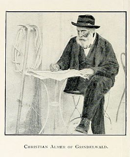
Christian Almer was a Swiss mountain guide and the first ascentionist of many prominent mountains in the western Alps during the golden and silver ages of alpinism.
The Nesthorn is a mountain in the Bernese Alps. It is located in the Swiss canton of Valais north of Brig. The mountain lies between the Oberaletsch Glacier on the north and east side and the Gredetschtal on the south side. It is part of the subrange of the Bernese Alps that culminates at the Aletschhorn.

The Grand Muveran is a mountain of the Bernese Alps, located on the border between the cantons of Vaud and Valais. At 3,051 metres, it is the highest summit of the group lying between the Rhone knee and the Pas de Cheville and the westernmost three-thousander of the Bernese Alps. The closest localities are Les Plans-sur-Bex and Ovronnaz (Valais). It is accompanied by the smaller peak of Petit Muveran.

The Schwarzhorn is a mountain of the Bernese Alps, located between Brienz and Grindelwald in the Bernese Oberland. With a height of 2,928 metres above sea level, it is the highest summit of the group north of the Grosse Scheidegg Pass. The Schwarzhorn is also the highest point in the municipality of Brienz.
The Ärmighorn is a mountain of the Bernese Alps, located east of Kandergrund in the Bernese Oberland. It lies north of the Dündenhorn, on the range between the Kandertal and the Kiental.

The Zahm Andrist is a mountain of the Bernese Alps, located south of Kiental in the Bernese Oberland. It lies west of the Hundshorn.

The Jungfrau-Aletsch protected area is located in south-western Switzerland between the cantons of Berne and Valais. It is a mountainous region in the easternmost side of the Bernese Alps, containing the northern wall of Jungfrau and Eiger, and the largest glaciated area in western Eurasia, comprising the Aletsch Glacier. The Jungfrau-Aletsch protected area is the first World Natural Heritage site in the Alps, it was inscribed in 2001.


