
Columbus is the capital and most populous city of the U.S. state of Ohio. With a 2020 census population of 905,748, it is the 14th-most populous city in the U.S., the second-most populous city in the Midwest after Chicago, and the third-most populous U.S. state capital. Columbus is the county seat of Franklin County; it also extends into Delaware and Fairfield counties. It is the core city of the Columbus metropolitan area, which encompasses 10 counties in central Ohio. It had a population of 2,138,926 in 2020, making it the largest metropolitan entirely in Ohio and 32nd-largest city in the U.S.
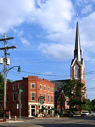
German Village is a historic neighborhood in Columbus, Ohio, just south of the city's downtown. It was settled in the early-to-mid-19th century by a large number of German immigrants, who at one time comprised as much as a third of the city's entire population. It became a city historic district in 1960 and was added to the National Register of Historic Places in 1974, becoming the list's largest privately funded preservation district, and in 2007, was made a Preserve America Community by the federal government. In 1980, its boundaries increased, and today it is one of the world's premier historic restorations.

San Margherita is an unincorporated neighborhood directly west of Columbus, Ohio, half falling into Norwich Township and the other half in Franklin Township. The area was settled in the early 20th century by Italian immigrants working for the Marble Cliff Quarry Company. Though once a robust and rural community, San Margherita is in danger of vanishing. Many of the original homes and locally owned businesses in the neighborhood have been demolished.

Franklinton is a neighborhood in Columbus, Ohio, just west of its downtown. Settled in 1797, Franklinton is the first American settlement in Franklin County, and was the county seat until 1824. As the city of Columbus grew, the city annexed and incorporated the existing settlement in 1859. Franklinton is bordered by the Scioto River on the north and east, Harmon Avenue on the east, Stimmel Road and Greenlawn Avenue on the south, and Interstate 70 on the west. Its main thoroughfare is West Broad Street, one of the city's two main roads.

Italian Village is a neighborhood in Columbus, Ohio, that contains an array of residential, commercial, and industrial buildings. It is a designated historic district, known for its historical and cultural preservation. The building types and architecture reflect Italian influence. With its parks and preserved historic homes, Italian Village has the highest home value appreciation in Columbus.
Linden is a neighborhood in northeastern Columbus, Ohio. It was established in 1908 as Linden Heights Village, and was annexed into Columbus in 1921. The neighborhood saw high levels of development in the 1920s. By the 1960s, suburban development and racial factors caused families, especially white residents, to leave the neighborhood. Since this time, Linden has struggled with poverty, crime, vacancies, and health and societal problems.

Downtown Columbus is the central business district of Columbus, Ohio. Downtown is centered on the intersection of Broad and High Streets, and encompasses all of the area inside the Inner Belt. Downtown is home to most of the tallest buildings in Columbus.
Columbus, the state capital and Ohio's largest city, has numerous neighborhoods within its city limits. Neighborhood names and boundaries are not officially defined. They may vary or change from time to time due to demographic and economic variables.
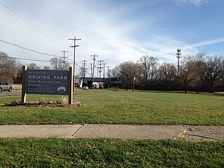
Driving Park is an urban residential area on the Near East Side of Columbus, Ohio just south of Interstate 70. Mainly a middle-class, predominantly African American neighborhood, Driving Park and its surrounding neighborhoods consist of an area of 17,730 residents. Driving Park received its name from its historic past as a large racing complex, first for horses and later for automobiles.

The First Hungarian Reformed Church of New York is located on East 69th Street in the Upper East Side of the New York City borough of Manhattan. It is a stucco-faced brick building, completed in 1916 in a Hungarian vernacular architectural style, housing a congregation established in 1895.

Old North Columbus is a neighborhood located just north of the Ohio State University in Columbus, Ohio. It was founded in 1847 where, at the time, it was a stand-alone city out of the confines of Columbus until it was incorporated into the City of Columbus in 1871. In its early years the city was a popular stagecoach stop with people traveling from Worthington to Columbus. Today Old North Columbus is popular for its local music and its unique "untouched architecture" which is reminiscent of its old roots.
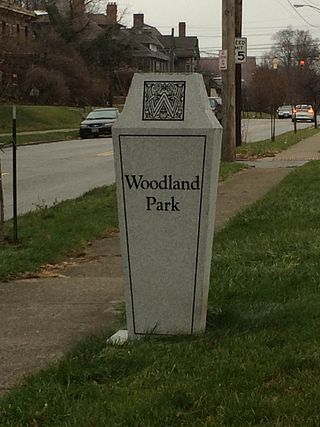
Woodland Park is a residential neighborhood located in the Near East Side of Columbus, Ohio that houses approximately 1,500 residents. The neighborhood was previously home to such figures as artist Emerson Burkhart, cartoonist Billy Ireland, and judge William Brooks. Established in the early 20th century, Woodland Park has grown from its planned neighborhood roots into a modest neighborhood that contains various faith communities, schools, sources of entertainment and recreation, and borders an extension of the Ohio State University medical center.
Milo-Grogan is a neighborhood of Columbus, Ohio. The neighborhood was settled as the separate communities of Milo and Grogan in the late 1870s. Large-scale industrial development fueled the neighborhood's growth until the 1980s, when the last factories closed. The community has received urban renewal efforts in recent years fueled by the Columbus Department of Development and Milo-Grogan Area Commission.

Weinland Park is a neighborhood north of downtown Columbus, Ohio and encompassed by the boundaries of the University District. A development boom in the 1930s and 1940s resulting from new streetcar lines and the blossoming of factories brought working and middle-class families to the neighborhood. Current housing stock consists primarily of single family residential buildings that have been converted to rentals or multifamily housing. Row-homes and apartment buildings are also ubiquitous in the neighborhood. Renters currently outnumber owners. Commercial and entertainment facilities are concentrated on the North High Street corridor, but also pocket the inner part of the neighborhood as well. Weinland Park saw the sapping of its population and wealth with the rise of newer suburbs ringing the outer reaches of the city and the collapse of local industry and streetcar lines. The neighborhood has been plagued with crime and drug problems for decades but has recently seen a flood of new investment that has brought growth and revitalization to this long struggling neighborhood. Investment into the community includes the South Campus Gateway providing retail and residential finished in 2005, and a new food district and employment center.

Franklin Park is a neighborhood located on the Near East Side of Columbus, Ohio. Both the historic neighborhood and landmark, the Franklin Park Conservatory and Botanical Gardens, are named after the 88-acre park.

Southern Orchards is an established neighborhood on the near south side of Columbus, Ohio. It is located immediately southeast of downtown and is the 23rd most walkable neighborhood in Columbus with 3,538 residents. The neighborhood is the target of revitalization and beautification largely due to its anchor institution Nationwide Children's Hospital and a renewed interest in urban living in the city's core. Since 2008, more than 90 properties have been improved through the hospital’s Healthy Homes program and continued revitalization is occurring along the major streets of Livingston and Parsons Avenues as the city moves to reconnect downtown to its surrounding neighborhoods.
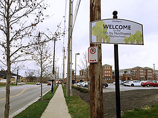
Fifth by Northwest is a neighborhood in Columbus, Ohio. Covering about 700 acres (280 ha), Fifth by Northwest is approximately bound by Glenn Avenue, Wyandotte Road, & Kinnear to the north, Third Avenue to the south, Kenny Road and Olentangy River Road to the east and Northstar Road to the west. Also sometimes referred to as 5XNW or the Tri-Village area, Fifth by Northwest is just north of Grandview Heights, northwest of the Harrison West neighborhood, and west of The Ohio State University.

Tosheff's Restaurant and Hotel is a historic building in the Reeb-Hosack neighborhood of Columbus, Ohio. It was built in 1920 and was listed on the National Register of Historic Places in 2001. The restaurant and hotel are one of few remainders of the historic Steelton industrial area, and closely connected to the eastern European neighborhood there. The industrial district was centered on Parsons Avenue, and relied upon the Buckeye Steel Castings Company, American Rolling Mill Company, the Chase Foundry and Manufacturing Company, the Federal Glass Company, and the Seagraves firetruck manufacturing plant.

The Reeb Avenue Center is a community center and 501(c)(3) in the Reeb-Hosack neighborhood of Columbus, Ohio. The Reeb Center opened in 2015, after a $12.5 million renovation. The Center and its multiple nonprofit subtenants provide services including workforce development and job training, early learning preschool and child care, after-school and summer programming for school-aged children, a variety of social services, and a cafe which serves weekday lunches and Tuesday evening dinner. During the COVID-19 pandemic, the Center partially closed for three months, then began reopening in May 2020 to promptly return to serving local area residents.

The Trolley District is a mixed-use complex in Columbus, Ohio. The three-acre (1.2 ha) site houses the East Market, a public market and food hall, as well as two bars, and will also include restaurants, a brewery, and event space, with neighboring apartments. The property is located in the city's Franklin Park neighborhood and is a contributing part of the Columbus Near East Side District, listed on the National Register of Historic Places.


