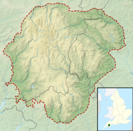
Dartmoor is an upland area in southern Devon, South West England. The moorland and surrounding land has been protected by National Park status since 1951. Dartmoor National Park covers 954 km2 (368 sq mi).
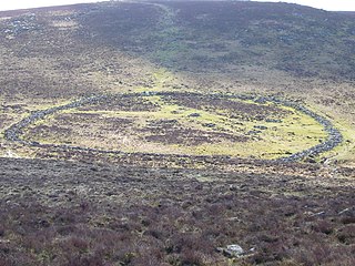
Grimspound is a late Bronze Age settlement, situated on Dartmoor in Devon, England. It consists of a set of 24 hut circles surrounded by a low stone wall. The name was first recorded by the Reverend Richard Polwhele in 1797; it was probably derived from the Anglo-Saxon god of war, Grim.

Hod Hill is a large hill fort in the Blackmore Vale, 3 miles (5 km) north-west of Blandford Forum, Dorset, England. The fort sits on a 143 m (469 ft) chalk hill of the same name that lies between the adjacent Dorset Downs and Cranborne Chase. The hill fort at Hambledon Hill is just to the north. The name probably comes from Old English "hod", meaning a shelter, though "hod" could also mean "hood", referring to the shape of the hill.

Dunkery Beacon at the summit of Dunkery Hill is the highest point on Exmoor and in Somerset, England. It is also the highest point in southern England outside of Dartmoor.

Chanctonbury Ring is a prehistoric hill fort atop Chanctonbury Hill on the South Downs, on the border of the civil parishes of Washington and Wiston in the English county of West Sussex. A ridgeway, now part of the South Downs Way, runs along the hill. It forms part of an ensemble of associated historical features created over a span of more than 2,000 years, including round barrows dating from the Bronze Age to the Saxon periods and dykes dating from the Iron Age and Roman periods.

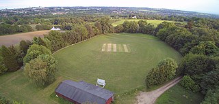
Lustleigh is a small village and civil parish in the Wray Valley, inside the Dartmoor National Park in Devon, England. It is between the towns of Bovey Tracey and Moretonhampstead. The village has often been named amongst the best or prettiest villages in the country in various publications, particularly due to the traditional thatched buildings in the village centre, and local activities such as the Lustleigh Show. This has also led to it being noted as the most expensive rural location to buy a house.

Prestonbury Castle is an Iron Age Hill fort on the north east edge of Dartmoor in Devon, England. Situated on a massive hilltop some 240 metres above sea level overlooking the Teign Valley, it is located near two other hill forts both of which lie about 2 km (1 mi) away.

Brent Tor is a tor on the western edge of Dartmoor, approximately four miles (6.5 km) north of Tavistock, rising to 1100 ft (330m) above sea level. The Tor is surmounted by the Church of St Michael, the parish church of the village of Brentor, which lies below the Tor.
Mellor hill fort is a prehistoric site in North West England, that dates from the British Iron Age—about 800 BC to 100 AD. Situated on a hill in Mellor, Greater Manchester, on the western edge of the Peak District, the hill fort overlooks the Cheshire Plain. Although the settlement was founded during the Iron Age, evidence exists of activity on the site as far back as 8,000 BC; during the Bronze Age the hill may have been an area where funerary practices were performed. Artefacts such as a Bronze Age amber necklace indicate the site was high status and that its residents took part in long-distance trade. The settlement was occupied into the Roman period. After the site was abandoned, probably in the 4th century, it was forgotten until its rediscovery in the 1990s.
Worlebury Camp is the site of an Iron Age hillfort on Worlebury Hill, north of Weston-super-Mare in Somerset, England. The fort was well defended with numerous walls, embankments and ditches around the site. Several large triangular platforms have been uncovered around the sides of the fort, lower down on the hillside. Nearly one hundred storage pits of various sizes were cut into the bedrock, and many of these contained human remains, coins, and other artefacts. During the 19th and 20th centuries the fort suffered damage and was threatened with complete destruction on multiple occasions. Now, the site is a designated Scheduled monument. It falls within the Weston Woods Local Nature Reserve which was declared to Natural England by the North Somerset Council in 2005.

Torberry Hill is an Iron Age hillfort in the county of West Sussex, in southern England. It is a Scheduled Ancient Monument, with a list entry identification number of 1015966. The hill fort is located within the parish of Harting, within the South Downs National Park. The hill includes the remains of an Early Iron Age univallate hill fort, a Middle Iron Age promontory fort and a post-medieval post mill. The hill is a chalk spur projecting northwards from the South Downs.

Beacon Hill, also known as Harting Beacon, is a hillfort on the South Downs, in the county of West Sussex in southern England. The hillfort is located in the parish of Elsted and Treyford, in Chichester District. It is a Scheduled Ancient Monument with a list entry identification number of 1015915. The hilltop enclosure is dated to the Late Bronze Age, from the 8th to 6th centuries BC. The hillfort defences were renewed during the Late Iron Age.
King John's Hill is the site of an Iron Age hillfort located in Hampshire, in southeast England. The hill is situated in the parish of Worldham, in East Hampshire District. It is a Scheduled Ancient Monument with a list entry identification number of 1020314, and a Monument Number of 243207.

Warbstow Bury is an Iron Age hillfort about 0.5 miles (0.80 km) west of the village of Warbstow, in Cornwall, England. It is a scheduled monument.
Sharp Tor is a common name given to tors (outcrops), particularly on Dartmoor and Bodmin Moor. All the "Sharp Tors" are listed below with their location and height:

Cadson Bury is an Iron Age hillfort about 2 miles (3.2 km) south-west of Callington, in Cornwall, England.

Thundersbarrow Hill is an archaeological site in West Sussex, England. It is on a chalk ridge, aligned north-west to south-east, on the South Downs north of Shoreham-by-Sea.
South Weald Camp was a hillfort based in South Weald, Brentwood, Essex, England. Roughly circular in plan, the fort covered 2.8 hectares, with a suggested construction date in the late Iron Age, from the 1st century BC to the 1st century AD. The location is associated in this period with the Catuvellauni and the Trinovantes.
Sutreworde was a village and manor in historical record, also noted as Suðeswyrðe, located within the Teignbridge Hundred. The modern identity of this village has been the subject of academic debate, but is thought to have been within the parish of Lustleigh, but not at the location of the current village.

The Lustleigh Cleave is a steep sided valley above the River Bovey in the parish of Lustleigh on Dartmoor. The cleave has been noted for its beauty since the 1800s, and features extensively in guidebooks.