Lake Michigan is one of the five Great Lakes of North America. It is the second-largest of the Great Lakes by volume and the third-largest by surface area, after Lake Superior and Lake Huron. To the east, its basin is conjoined with that of Lake Huron through the narrow Straits of Mackinac, giving it the same surface elevation as its easterly counterpart; the two are technically a single lake.

Leelanau County is located in the U.S. state of Michigan. As of the 2020 Census, the population was 22,301. The county seat was until recently the unincorporated community of Leland. On August 3, 2004, county voters approved a proposal to move the county seat to Suttons Bay, closer to the county's geographic center. In 2008, the county offices completed their move to a new government center built on 45 acres (180,000 m2) of county-owned land, one mile east of the unincorporated village of Lake Leelanau, where a new county law enforcement center was completed.

Glen Arbor Township is a civil township of Leelanau County in the U.S. state of Michigan. The population was 859 at the 2010 census. However, the population of the town expands rapidly during the summer months as a result of it being a summer colony.

Sleeping Bear Dunes National Lakeshore is a United States National Lakeshore located along the northwest coast of the Lower Peninsula of Michigan in Leelanau and Benzie counties near Empire, Michigan. The park covers a 35-mile-long (56 km) stretch of Lake Michigan's eastern coastline, as well as North and South Manitou islands. This Northern Michigan park was established primarily because of its outstanding natural features, including forests, beaches, dune formations, and ancient glacial phenomena. The lakeshore also contains many cultural features including the 1871 South Manitou Island Lighthouse, three former stations of the Coast Guard and an extensive rural historic farm district. In 2011, the area won the title of "The Most Beautiful Place in America" from Good Morning America. In 2014, a section of the park was named the Sleeping Bear Dunes Wilderness by the United States Congress.

North Manitou Island is located in Lake Michigan, approximately 12 miles (19 km) west-northwest of Leland, Michigan. It is nearly eight miles long and more than four miles (6 km) wide, with 20 miles (32 km) of shoreline. It has a land area of 57.876 km2 and has no population. The smaller South Manitou Island lies to its southwest.
South Manitou Island is located in Lake Michigan, approximately 16 miles (26 km) west of Leland, Michigan. It is part of Leelanau County and the Sleeping Bear Dunes National Lakeshore. The uninhabited island is 8.277 sq mi (21.44 km2) in land area and can be accessed by a ferry service from Leland. Guided tours on open-air vehicles are available to visitors, but most traffic is on foot. Larger North Manitou Island lies to its north.

Leland is an unincorporated community and census-designated place (CDP) in the U.S. state of Michigan. As of the 2010 census it had a population of 377. It was the county seat of Leelanau County from 1883 to 2008, when a new government center was completed in Suttons Bay Township, closer to the county's geographic center.
M-209 was a state trunkline highway in the Lower Peninsula of the US state of Michigan. It was located in Leelanau County in the Sleeping Bear Dunes National Lakeshore. Until it was decommissioned, it was Michigan's shortest state highway. M-209 started at M-109 and went just over 1⁄2 mile to Glen Haven. In 1996, M-209's designation was "abandoned", and the road was turned over to the jurisdiction of the Leelanau County Road Commission.
Cliff-top dunes, also known as perched dunes, are dunes that occur on the tops of cliffs. They are uncommon in most parts of the world, because they only develop under unusual geomorphological conditions. Processes by which they may be formed include:

Glen Haven is a restored port village on the shore of Lake Michigan on the Leelanau Peninsula within the now Sleeping Bear Dunes National Lakeshore. Attractions include the Lake Michigan beach, a restored General Store and Blacksmith Shop. The unincorporated community is located in Glen Arbor Township.

South Manitou Island Lighthouse is located on South Manitou Island in Lake Michigan, 16 miles (26 km) west of Leland, Michigan. It is in Leelanau County in western Northern Michigan.
Coker Experimental Farms, also known as Coker Pedigreed Seed Company, is a National Historic Landmark agricultural site at 1257 South Fourth Street in Hartsville, South Carolina, USA. Now a museum property, the property was where David R. Coker performed critical breeding experiments to improve strains of cotton and other crops grown throughout the American South. Coker was a major force in the development of agricultural extension services in the South in the early decades of the 20th century. What remains of his farm was declared a National Historic Landmark in 1964.

North Manitou Island Lifesaving Station, also known as North Manitou Coast Guard Station, is a complex of buildings located on North Manitou Island, which is part of Sleeping Bear Dunes National Lakeshore in Michigan, in the U.S. The complex was constructed as a life-saving station. It is the only remaining station which was in use during all three periods of lifesaving service history, from the early volunteer period through operation by the United States Life-Saving Service and the United States Coast Guard. It was declared a National Historic Landmark in 1998.
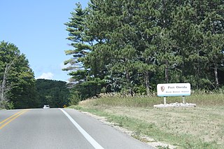
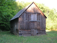
Port Oneida Rural Historic District is part of the Sleeping Bear Dunes National Lakeshore. It consists of a set of farms in the Leelanau Peninsula of Northern Michigan that are typical of Northern European settlers throughout the Midwestern United States in the later part of the 19th century.

Chellberg Farm is a historic farmstead which in 1972 became part of Indiana Dunes National Park. Chellberg Farm is significant as it represents the ethnic heritage of a nearly forgotten Swedish-American settlement. The farm includes a family home, water house with windmill, chicken coop/bunkhouse, and the original barn. Other nearby Swedish landmarks have been restored or preserved, including the Burstrom Chapel and the Burstrom Cemetery.

The Manitou Passage Underwater Preserve is a preservation area in the U.S. state of Michigan. Located in Lake Michigan, it completely surrounds North Manitou Island and South Manitou Island. It includes much of that portion of Lake Michigan that borders the federally protected Sleeping Bear Dunes National Lakeshore.
The Paul Harvey Deming House was a private residence located at 111 Lake Shore Rd. in Grosse Pointe Farms, Michigan. It was listed on the National Register of Historic Places and designated a Michigan State Historic Site in 1996 and demolished in 1997.

The George Conrad Hutzler Farm, also known as the Conrad Hutzler Farm, is a historic farmstead located on South Manitou Island in Lake Michigan. One of the farm's owners, George Conrad Hutzler, Jr., was the first to experiment with hybridization of Rosen rye and Michelite pea beans; within 20 years of his experimentation, 80% of the pea bean crop in the United States was descended from Michelite seeds grown on South Manitou Island. It was listed on the National Register of Historic Places in 1991.

The Sleeping Bear Dunes National Lakeshore Conservation and Recreation Act is a law that designated as wilderness about 32,500 acres of the Sleeping Bear Dunes National Lakeshore in the state of Michigan. The newly designated lands and inland waterways comprise the Sleeping Bear Dunes Wilderness, a new component of the National Wilderness Preservation System.