Iskut River Hot Springs Provincial Park is a 4-hectare (9.9-acre) provincial park in British Columbia, Canada, located on the western side of the Iskut River.
Tuber Hill is a small 600,000-year-old basaltic stratovolcano that was constructed on the Bridge River highlands when nearby valleys were packed with ice. Tuber Hill is part of the Garibaldi segment of the Canadian Cascade Arc, but is not in the geographic Cascade Range.
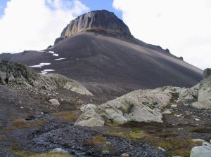
Little Bear Mountain is a basaltic Pleistocene age tuya in the Boundary Ranges of the Coast Mountains that adjoins Hoodoo Mountain to the north. Little Bear Mountain is part of the Northern Cordilleran Volcanic Province.
Mount Job is one of six named volcanic peaks of the Mount Meager massif in British Columbia, Canada. It is a pile of rubble held together by volcanic ash and sand. The main summit of Mount Job is hard to climb because of difficult access and its horribly loose rock.
Capricorn Mountain is one of the several volcanic peaks of the Mount Meager massif in southwestern British Columbia, Canada. Its slopes appear to be more gentle than those of the massif's other volcanic peaks. The mountain consists of a boomerang-shaped ridge, with one summit at each end and the main summit in the centre.
Toozaza Peak is a tuya in the Stikine Ranges of the Cassiar Mountains in northern British Columbia, Canada, located in the Iverson Creek. Toozaza Peak is the summit of a north–south aligned ridge between the head of Toozaza Creek and the head of the Jennings River, just south of the Jennings' divide with the Little Rancheria River headwaters. The Little Rancheria and Toozaza Creek are part of the Liard, while the Jennings is part of the Yukon River drainage via Teslin Lake, and the peak therefore stands astride the line of the Continental Divide. It is part of the Tuya Volcanic Field, a volcanic field associated with the Stikine Volcanic Belt, part of the Northern Cordilleran Volcanic Province.
Cauldron Dome is a tuya in the Mount Cayley volcanic field, British Columbia, Canada. Cauldron Dome is made of coarsely plagioclase-orthophyroxene-phyric andesite lava flows and last erupted during the Holocene. It is in the Garibaldi Volcanic Belt, a portion of the Canadian Cascade Arc.
Mount Overill is a volcanic peak in southwestern British Columbia, Canada, located 81 km (50 mi) east of Rivers Inlet and 2 km (1 mi) northwest of Mount Somolenko.
Little Ring Mountain, also called Little Ring Peak, is a tuya in the Pacific Ranges of the Coast Mountains in southwestern British Columbia, Canada. It lies at the head of the Squamish and Soo Rivers. Part of the Mount Cayley volcanic field, its most recent eruption most likely occurred during the Fraser Glaciation.
Ridge Cone is a cinder cone in northern British Columbia, Canada. It is thought to have last erupted in the Holocene period and is part of the Mount Edziza volcanic complex.
Twin Cone is a cinder cone in northern British Columbia, Canada. It is thought to have last erupted in the Holocene period.
Triangle Dome is a trachytic lava dome in northern British Columbia, Canada. It is thought to have formed in the Pleistocene period.
Camp Hill is a cinder cone in northern British Columbia, Canada. It is thought to have last erupted in the Holocene period.
Meehaz Mountain is a mountain in the Cassiar Country of the Northern Interior of British Columbia, Canada, located on the north side of the headwaters of Teslin River and to the south of the Atsutla Range. It is a product of subglacial volcanism during the Pleistocene period when this area was covered by thick glacial ice, forming a subglacial volcano that never broke through the overlying glacial ice known as a subglacial mound.
Nuthinaw Mountain is a mountain on the Stikine Plateau in northern British Columbia, Canada, located east of Tutsingale Mountain and 72 km (45 mi) northwest of Dease Lake on the north side of Tachilta Lakes. It is a product of subglacial volcanism during the Pleistocene period when this area was covered by thick glacial ice, forming a subglacial volcano that never broke through the overlying glacial ice known as a subglacial mound.
Tutsingle Mountain is a mountain on the Stikine Plateau in northern British Columbia, Canada, located east of Nuthinaw Mountain and northwest of Dease Lake on the northeast side of the Tachilta Lakes. It is a product of subglacial volcanism during the Pleistocene period when this area was covered by thick glacial ice, forming a subglacial volcano that never broke through the overlying glacial ice known as a subglacial mound.
Volcanism of Western Canada has produced lava flows, lava plateaus, lava domes, cinder cones, stratovolcanoes, shield volcanoes, greenstone belts, submarine volcanoes, calderas, diatremes and maars, along with examples of more less common volcanic forms such as tuyas and subglacial mounds.
Pharaoh Dome is a lava dome in northwestern British Columbia, Canada, located near Mount Edziza in Mount Edziza Provincial Park. It last erupted during the Pleistocene epoch.
Sphinx Dome is a lava dome in northwestern British Columbia, Canada, located near Mount Edziza in Mount Edziza Provincial Park. It last erupted during the Pleistocene epoch.
Isspah Butte is a tuya in the Atsutla Range of the Kawdy Plateau in northern British Columbia, Canada. It lies on the north side of the Nazcha Creek.
