Related Research Articles

A wireless network is a computer network that uses wireless data connections between network nodes.

Wardriving is the act of searching for Wi-Fi wireless networks by a person usually in a moving vehicle, using a laptop or smartphone. Software for wardriving is freely available on the internet.

A cell site, cell tower, or cellular base station is a cellular-enabled mobile device site where antennae and electronic communications equipment are placed—typically on a radio mast, tower, or other raised structure—to create a cell in a cellular network. The raised structure typically supports antenna and one or more sets of transmitter/receivers transceivers, digital signal processors, control electronics, a GPS receiver for timing, primary and backup electrical power sources, and sheltering.

Mobile computing is human–computer interaction in which a computer is expected to be transported during normal usage, which allows for transmission of data, voice and video. Mobile computing involves mobile communication, mobile hardware, and mobile software. Communication issues include ad hoc networks and infrastructure networks as well as communication properties, protocols, data formats and concrete technologies. Hardware includes mobile devices or device components. Mobile software deals with the characteristics and requirements of mobile applications.
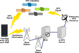
Assisted GPS or Augmented GPS is a system that often significantly improves the startup performance—i.e., time-to-first-fix (TTFF)—of a GPS satellite-based positioning system. A-GPS is extensively used with GPS-capable cellular phones, as its development was accelerated by the U.S. FCC's 911 requirement to make cell phone location data available to emergency call dispatchers.

Mobile phone tracking is a process for identifying the location of a mobile phone, whether stationary or moving. Localization may be affected by a number of technologies, such as using multilateration of radio signals between (several) cell towers of the network and the phone, or simply using GPS. To locate a mobile phone using multilateration of radio signals, it must emit at least the roaming signal to contact the next nearby antenna tower, but the process does not require an active call. The Global System for Mobile Communications (GSM) is based on the phone's signal strength to nearby antenna masts.
Radiolocating is the process of finding the location of something through the use of radio waves. It generally refers to passive uses, particularly radar—as well as detecting buried cables, water mains, and other public utilities. It is similar to radionavigation, but radiolocation usually refers to passively finding a distant object rather than actively one's own position. Both are types of radiodetermination. Radiolocation is also used in real-time locating systems (RTLS) for tracking valuable assets.
Proximity marketing is the localized wireless distribution of advertising content associated with a particular place. Transmissions can be received by individuals in that location who wish to receive them and have the necessary equipment to do so.
A local positioning system (LPS) is a navigation system that provides location information in all weather, anywhere within the coverage of the network, where there is an unobstructed line of sight to three or more signaling beacons of which the exact position on earth is known. A special type of LPS is the real-time locating system; which also allows real-time tracking of an object or person in a confined area such as a building.
Skyhook is a mobile location services company based in Boston, MA that specializes in location positioning, context and intelligence. Founded in 2003, Skyhook originally began by geolocating Wi-Fi access points and evolved with the idea that hybrid positioning technology, which incorporates Wi-Fi, GPS, cell towers, IP address and device sensors, could improve device location. The firm expanded their product set in 2015 to deliver advertising segments and behavioral insights; emphasizing data privatization and security for their advertising technology and mobile app customers. In 2016, the firm introduced Precision Location to power Wearables and the Internet of Things, and launched products Personas and Context Accelerator to help brands reach out to mobile consumers.
An indoor positioning system (IPS) is a network of devices used to locate people or objects where GPS and other satellite technologies lack precision or fail entirely, such as inside multistory buildings, airports, alleys, parking garages, and underground locations. A large variety of techniques and devices are used to provide indoor positioning ranging from reconfigured devices already deployed such as smartphones, WiFi and Bluetooth antennas, digital cameras, and clocks; to purpose built installations with relays and beacons strategically placed throughout a defined space. IPS has broad applications in commercial, military, retail, and inventory tracking industries. There are several commercial systems on the market, but no standards for an IPS system. Instead each installation is tailored to spatial dimensions, building materials, accuracy needs, and budget constraints. Lights, radio waves, magnetic fields, acoustic signals, and behavioral analytics are all used in IPS networks. IPS can achieve position accuracy of 2cm, which is on par with RTK enabled GNSS receivers that can achieve 2cm accuracy outdoors.

Radio is the technology of signaling and communicating using radio waves. Radio waves are electromagnetic waves of frequency between 30 hertz (Hz) and 300 gigahertz (GHz). They are generated by an electronic device called a transmitter connected to an antenna which radiates the waves, and received by a radio receiver connected to another antenna. Radio is very widely used in modern technology, in radio communication, radar, radio navigation, remote control, remote sensing and other applications.
Wi-Fi positioning system (WPS), WiPS or WFPS is a geolocation system that uses the characteristics of nearby Wi-Fi hotspots and other wireless access points to discover where a device is located. It is used where satellite navigation such as GPS is inadequate due to various causes including multipath and signal blockage indoors, or where acquiring a satellite fix would take too long. Such systems include assisted GPS, urban positioning services through hotspot databases, and indoor positioning systems. Wi-Fi positioning takes advantage of the rapid growth in the early 21st century of wireless access points in urban areas.
Fixed–mobile convergence (FMC) is a change in telecommunications that removes differences between fixed and mobile networks.
Real-time geotagging is a name given to the automatic technique of acquiring media, associating a specific location with the media, transferring the media to an online map and publishing the media in real time. It is thus an extension of an automatic geotagging process, requiring an in-built or attached location acquisition device, but also requires communication with a wireless data transfer device. Several modern cell phones and digital cameras already integrate camera, aGPS, and wireless data transfer into one device, thus directly producing a geotagged photograph. Real-time geotagging is sometimes referred to as "mobile geotagging" or "autogeotagging", but this does not imply the real-time publishing step.
A Satellite navigation device, colloquially called a GPS receiver, or simply a GPS, is a device that is capable of receiving information from GNSS satellites and then to calculate the device's geographical position. Using suitable software, the device may display the position on a map, and it may offer routing directions. The Global Positioning System (GPS) is one of a handful of global navigation satellite systems (GNSS) made up of a network of a minimum of 24, but currently 30, satellites placed into orbit by the U.S. Department of Defense.

Navizon, Inc. is a provider of location-based services and products. Navizon was an early developer of technology that makes it possible to determine the geographic position of a mobile device using as reference the location of cell phone towers and Wi-Fi-based wireless access points instead of GPS. Navizon also developed technology for locating mobile devices indoors with room and floor-level accuracy.
Real-time locating systems (RTLS) are used to automatically identify and track the location of objects or people in real time, usually within a building or other contained area. Wireless RTLS tags are attached to objects or worn by people, and in most RTLS, fixed reference points receive wireless signals from tags to determine their location. Examples of real-time locating systems include tracking automobiles through an assembly line, locating pallets of merchandise in a warehouse, or finding medical equipment in a hospital.
The W3C Geolocation API is an effort by the World Wide Web Consortium (W3C) to standardize an interface to retrieve the geographical location information for a client-side device. It defines a set of objects, ECMAScript standard compliant, that executing in the client application give the client's device location through the consulting of Location Information Servers, which are transparent for the application programming interface (API). The most common sources of location information are IP address, Wi-Fi and Bluetooth MAC address, radio-frequency identification (RFID), Wi-Fi connection location, or device Global Positioning System (GPS) and GSM/CDMA cell IDs. The location is returned with a given accuracy depending on the best location information source available.
A GSM Cell ID (CID) is a generally unique number used to identify each base transceiver station (BTS) or sector of a BTS within a location area code (LAC) if not within a GSM network.
References
- ↑ AlterGeo: About us http://platform.altergeo.ru/index.php?mode=about
- ↑ Energy-Efficient Positioning for Smartphones using Cell-ID Sequence Matching by Jeongyeup Paek, Kyu-Han Kim, Jatinder P. Singh, Ramesh Govindan