Enhanced 911, E-911 or E911 is a system used in North America to automatically provide the caller's location to 911 dispatchers. 911 is the universal emergency telephone number in the region. In the European Union, a similar system exists known as E112 and known as eCall when called by a vehicle.
Geo- is a prefix derived from the Greek word γη or γαια, meaning "earth", usually in the sense of "ground or land"; as a prefix, it may also mean "global" or relate to the planet Earth.
In the context of information security, and especially network security, a spoofing attack is a situation in which a person or program successfully identifies as another by falsifying data, to gain an illegitimate advantage.
A geocode is a code that represents a geographic entity. It is a unique identifier of the entity, to distinguish it from others in a finite set of geographic entities. In general the geocode is a human-readable and short identifier.
In computing, geolocation software is software that is capable of deducing the geolocation of a device connected to the Internet. The identification of a device's IP address can be used to determine the country, city, or post/ZIP code, determining an object's geographical location. Other methods include examination of a MAC address, image metadata, or credit card information.

A geotagged photograph is a photograph which is associated with a geographical location by geotagging. Usually this is done by assigning at least a latitude and longitude to the image, and optionally altitude, compass bearing and other fields may also be included.
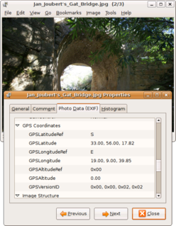
Geotagging, or GeoTagging, is the process of adding geographical identification metadata to various media such as a geotagged photograph or video, websites, SMS messages, QR Codes or RSS feeds and is a form of geospatial metadata. This data usually consists of latitude and longitude coordinates, though they can also include altitude, bearing, distance, accuracy data, and place names, and perhaps a time stamp.
Geocoding is the process of taking input text, such as an address or the name of a place, and returning a latitude/longitude location on the Earth's surface for that place. Reverse geocoding, on the other hand, converts geographic coordinates to a description of a location, usually the name of a place or an addressable location. Geocoding relies on a computer representation of address points, the street / road network, together with postal and administrative boundaries.
Multilateration is a navigation and surveillance technique based on measurement of the times of arrival (TOAs) of energy waves having a known propagation speed. Prior to computing a solution, the time of transmission (TOT) of the waves is unknown to the receiver.
In marketing, geomarketing is a discipline that uses geolocation in the process of planning and implementation of marketing activities. It can be used in any aspect of the marketing mix – the product, price, promotion, or place. Market segments can also correlate with location, and this can be useful in targeted marketing.
Georeferencing means that the internal coordinate system of a map or aerial photo image can be related to a ground system of geographic coordinates. The relevant coordinate transforms are typically stored within the image file, though there are many possible mechanisms for implementing georeferencing. The most visible effect of georeferencing is that display software can show ground coordinates and also measure ground distances and areas. In other words, Georeferencing means to associate something with locations in physical space. The term is commonly used in the geographic information systems field to describe the process of associating a physical map or raster image of a map with spatial locations. Georeferencing may be applied to any kind of object or structure that can be related to a geographical location, such as points of interest, roads, places, bridges, or buildings.

Geotargeting in geomarketing and internet marketing is the method of determining the geolocation of a website visitor and delivering different content to that visitor based on their location. This includes country, region/state, city, metro code/zip code, organization, IP address, ISP or other criteria. A common usage of geo targeting is found in online advertising, as well as internet television with sites such as iPlayer and Hulu. In these circumstances, content is often restricted to users geolocated in specific countries; this approach serves as a means of implementing digital rights management. Use of proxy servers and virtual private networks may give a false location.
Geobytes is a global company specializing in geolocation and anti-spam software. Geobytes was incorporated in the State of Delaware, USA in 1999 making it one of the oldest companies in the online geolocation industry.
Wi-Fi positioning system (WPS), WiPS or WFPS is a geolocation system that uses the characteristics of nearby Wi-Fi hotspots and other wireless access points to discover where a device is located. It is used where satellite navigation such as GPS is inadequate due to various causes including multipath and signal blockage indoors, or where acquiring a satellite fix would take too long. Such systems include assisted GPS, urban positioning services through hotspot databases, and indoor positioning systems. Wi-Fi positioning takes advantage of the rapid growth in the early 21st century of wireless access points in urban areas.
Real-time geotagging is a name given to the automatic technique of acquiring media, associating a specific location with the media, transferring the media to an online map and publishing the media in real time. It is thus an extension of an automatic geotagging process, requiring an in-built or attached location acquisition device, but also requires communication with a wireless data transfer device. Several modern cell phones and digital cameras already integrate camera, aGPS, and wireless data transfer into one device, thus directly producing a geotagged photograph. Real-time geotagging is sometimes referred to as "mobile geotagging" or "autogeotagging", but this does not imply the real-time publishing step.
The Ricoh 500SE digital compact camera is suitable for outdoor photography and networkability. Capability includes external information such as GPS position or barcode numbers within the image headers. External vendors sell hardware and software for workflows involving GPS positioning or barcode scanning. Most NMEA compliant bluetooth GPS receivers can be used with this camera through its built in bluetooth communication capability. The body is resistant to dust and water, making it robust for many environments.
The W3C Geolocation API is an effort by the World Wide Web Consortium (W3C) to standardize an interface to retrieve the geographical location information for a client-side device. It defines a set of objects, ECMAScript standard compliant, that executing in the client application give the client's device location through the consulting of Location Information Servers, which are transparent for the application programming interface (API). The most common sources of location information are IP address, Wi-Fi and Bluetooth MAC address, radio-frequency identification (RFID), Wi-Fi connection location, or device Global Positioning System (GPS) and GSM/CDMA cell IDs. The location is returned with a given accuracy depending on the best location information source available.
Satellite geolocation is the process of locating the origin of a signal appearing on a satellite communication channel. Typically, this process is used to mitigate interference on communication satellites. Usually, these interference signals are caused by human error or equipment failure, but can also be caused by deliberate jamming. Identifying the geographical location of an interfering signal informs the mitigation activity.
In geographic information systems, toponym resolution is the relationship process between a toponym, i.e. the mention of a place, and an unambiguous spatial footprint of the same place.
Geomessaging is a technology that allows a person or system to send a message based on any media to a device that enters or exits one or more regions. Those regions can be created by using geofences, based on Latitude and Longitude, or adding beacons to the system associating those beacons with named locations. The device will receive the message according to the rules defined by the campaign administrator.
