
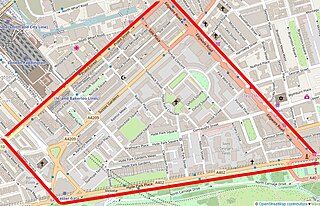
Connaught Square in London, England, was the first square of city houses to be built in Bayswater. It is named after a royal, the Earl of Connaught who was from 1805 until death in 1834 the second and last Duke of Gloucester and Edinburgh, and who maintained his fringe-of-London house and grounds on the land of this square and Gloucester Square. Its appearance is essentially the same as in the 1820s. Its south-east is 115 metres north of Hyde Park and the same west of Edgware Road. This point is 302 m (991 ft) WNW of Marble Arch, which sits on a very large green roundabout marking the western end of Oxford Street. Connaught Street runs along is northern end.

Squares have long been a feature of London and come in numerous identifiable forms. The landscaping spectrum of squares stretches from those with more hardscape, constituting town squares —to those with communal gardens, for which London is a major international exponent, known as garden squares.

St George's Fields are a former burial ground of St George's, Hanover Square, lying between Connaught Street and Bayswater Road in Tyburnia deconsecrated and sold off by the Church Commissioners in the 1970s to be built upon by The Utopian Housing Association, a housing trust.
Tyburnia, a part of Paddington in London, originally developed following an 1824 masterplan drawn up by Samuel Pepys Cockerell (1753-1827) to redevelop the historic lands of the Bishop of London, known as the Tyburn Estate, into a residential area to rival Belgravia. Tyburnia was the first part of Paddington to be developed.
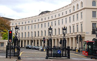
Park Crescent is at the north end of Portland Place and south of Marylebone Road in London. The crescent consists of elegant stuccoed terraced houses by the architect John Nash, which form a semicircle. The crescent is part of Nash's and wider town-planning visions of Roman-inspired imperial West End approaches to Regent's Park. It was originally conceived as a circus (circle) to be named Regent's Circus but instead Park Square was built to the north. The only buildings on the Regent's Park side of the square are small garden buildings, enabling higher floors of the Park Crescent buildings to have a longer, green northern view.

Park Square is a large garden square or private appendix to Regent's Park in London and is split from a further green, the long northern side of Park Crescent, by Marylebone Road and (single-entrance) Regent's Park tube station. It consists of two facing rows of large, very classically formed, stuccoed, terraced houses with decorative lower floor balconies and a colonnade of consecutive porticos by architect John Nash, and was built in 1823–24. Alike, shorter-length terraces flank its corners at right angles, equally Grade I listed buildings: Ulster Terrace, Ulster Place, St Andrew's Place and Albany Terrace.

As of February 2001, there were 1,124 listed buildings with Grade II status in the English city of Brighton and Hove. The total at 2009 was similar. The city, on the English Channel coast approximately 52 miles (84 km) south of London, was formed as a unitary authority in 1997 by the merger of the neighbouring towns of Brighton and Hove. Queen Elizabeth II granted city status in 2000.

Ladbroke Square is a garden square in Notting Hill, west London, England.

St. Andrews Square is a mainly 1876 to 1884-built garden square in Surbiton in the borough of Kingston upon Thames, London.
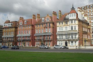
As of February 2001, there were 1,124 listed buildings with Grade II status in the English city of Brighton and Hove. The total at 2009 was similar. The city, on the English Channel coast approximately 52 miles (84 km) south of London, was formed as a unitary authority in 1997 by the merger of the neighbouring towns of Brighton and Hove. Queen Elizabeth II granted city status in 2000.
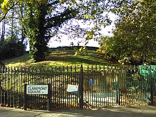
Claremont Square is a square in the Angel (Pentonville) part of Islington, London. Its central green mound, hiding a reservoir, is dotted with mature trees on all four sides (embankments). On its north side is Pentonville Road. It is lined on the south, east and west sides by early-nineteenth-century houses, and on the north side, across the arterial road, by heavily recessed apartment/office buildings. Many of the houses have been internally subdivided.

Trevor Square is an elongated garden square in Knightsbridge, London. It was designed in the 1810s chiefly by architect William Fuller Pocock, and the mid-rise, basemented houses fronting its two long sides, with slate mansard roofs are listed in the British protective and recognising scheme, and were built in the 1820s. The main stonemason employed was Lancelot Edward Wood after whom is named neighbouring street Lancelot Place.
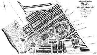
George Gutch (1790-1894) was a British architect and to four successive Bishops of London surveyor for much of the Diocese's c. 500-acre (2.0 km2) southern strip of the parish of Paddington.
The Hyde Park Estate is a residential district in the Paddington area of London. It is an affluent area, characterised by a layout of squares and crescents, and is home to several embassies, prestigious businesses and celebrities.

Myddelton Square, the largest square in Central London's Clerkenwell, is a residential public garden square of the 1820s to 1840s, with playground, with many trees; its houses are built with exposed brickwork, Georgian style, with high-ceilinged ground and first-floor storeys. Two of its houses were obliterated and rebuilt, and two declared unsafe and rebuilt, in the London Blitz.
Harrington Gardens is a street which has a communal garden regionally sometimes known as a garden square in the Royal Borough of Kensington and Chelsea in London. The street runs from Collingham Gardens and Collingham Road in the east to Gloucester Road and Stanhope Gardens in the west. It is crossed by Ashburn Place and joined by Colbeck Mews on its north side. It contains several listed buildings including an important group of grade II* buildings on the south side numbered 35 to 45.
Middleton is a town in the Metropolitan Borough of Rochdale, Greater Manchester, England, and it is unparished. The town and the surrounding countryside contain 45 listed buildings that are recorded in the National Heritage List for England. Of these, one is listed at Grade I, the highest of the three grades, seven are at Grade II*, the middle grade, and the others are at Grade II, the lowest grade. Until the coming of the Industrial Revolution Middleton was a village, then came the industries of silk, cotton and coal. The oldest listed buildings consist of a church and vicarage, country houses, a school, a public house, and a bridge. The Rochdale Canal passes through the area, and locks and a bridge on it are listed. The later listed buildings include more churches, houses and schools, a drinking fountain, a bank, a club, a cotton mill, a park feature, and war memorials. The architect Edgar Wood lived in the town and he, sometimes with his partner Henry Sellars, designed some of the later listed buildings.

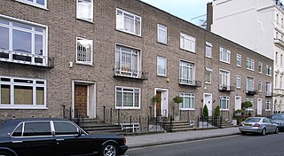
Connaught Street is a street in Central London. Located in the City of Westminster, it is part of the Tyburnia area of Paddington north of Hyde Park. It runs west to east from Hyde Park Square to the Edgware Road. It continues eastwards becoming Upper Berkeley Street in Marylebone. The street contains a mixture of commercial and residential properties, forming part of Connaught Village. Connaught Square and Albion Street are located on its southern side. The Duke of Kendal public house sits at the junction between Connaught Street and Kendal Street.


